13.18. Myanmar precipitation data#
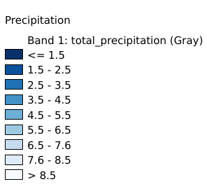
The annual average precipitation dataset was obtained through the GEE platform, and the data source is ERA5-Land of ECMWF, and the year is 2020. ERA5-Land is a high-resolution land reanalysis dataset with higher spatial resolution than the ERA5 dataset. It was generated by re-running the terrestrial component of the ECMWF ERA5 climate reanalysis system.Data source: https://www.ecmwf.int/en/forecasts/dataset/ecmwf-reanalysis-.Data format tif, spatial coordinate system WGS 84, mapping time 2025-04-01, cartographer Shen Jinlu.
Legend:#

Information:#
Path : /pb1/gisws/qgis_pub_map/svr_w24/shenjl_rsync/ch80_shenjl/sec16_Myanmar_earthquake/dataset_Myanmar_precipitation_tt/pub_Myanmar_precipitation.qgz
Layer Name : pub_Myanmar_precipitation_qn7369
Layer ID : qn7369
Center : 18.68406, 96.674446
Zoom : 5