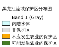
10.61. 黑龙江流域保护区分布图#
保护区地图是分辨率为 5 弧分的全球栅格数据图层。每个像素被分类为不应发生农业的保护区、可能发生农业的保护区或非保护区。通剪裁得到黑龙江流域保护区数据。数据来源(https://data.apps.fao.org/map/catalog/srv/eng/catalog.search#/metadata/b6aae9b0-f720-11db-b49b-000d939bc5d8),空间坐标系为WGS 84
Legend:#
Information:#
Path : /pb1/gisws/qgis_pub_map/svr_w24/shenjl_rsync/ch80_shenjl/sec13_Heilongjiang_Valley/Heilongjiang_Valley_protected/pub_Heilongjiang_Valley_protected.qgz
Layer Name : pub_Heilongjiang_Valley_protected_qn8521
Layer ID : qn8521
Center : 48.833332, 124.375
Zoom : 5
Powered by GISLite and Sphinx.