4.10. Yellow River Basin Study#
The Yellow River stretches 3,350 mi (5,400 km) through nine provinces in Northern China. Frequent flooding and droughts make water management on the Yellow a challenge. Each province along the Yellow is allocated a percentage of the river’s water supply according to China’s 1987 water allocation plan, which is administrated by the Yellow River Conservancy Commission. The predominant water use in the Yellow River basin is irrigated agriculture.The Yellow River Basin Study focuses on the specific characteristics of the indicator data and calculation in the Yellow River Basin. Coordinate system: WGS 84. Data source: https://www.wri.org/data/yellow-river-basin-study
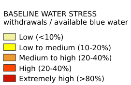
Legend:#

Information:#
Path : /pb1/gisws/qgis_pub_map/svr_w24/shenjl_rsync/ch80_shenjl/sec07_Water_Resources/Yellow_River_Basin_Study/pub_YellowRiver_BWS.qgz
Layer Name : pub_YellowRiver_BWS_qn1549
Layer ID : qn1549
Center : 36.995373, 107.46581
Zoom : 6