6.84. 2010 U.S. Socioeconomic Index Distribution Map#
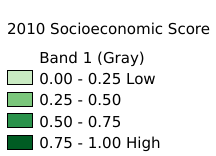
Distribution of socioeconomic status scores in the United States in 2010. Resolution: 1km. Coordinate system: WGS 84. Data source: https://sedac.ciesin.columbia.edu/data/set/usgrid-us-social-vulnerability-index
Legend:#

Information:#
Path : /pb1/gisws/qgis_pub_map/svr_w24/shenjl_rsync/ch80_shenjl/sec09_Social_Economic/US_SVI_Socioeconomic_Status_Score/pub_US_socioeconomic.qgz
Layer Name : pub_2010_US_socioeconomic_qn5390
Layer ID : qn5390
Center : 45.145832, -122.59583
Zoom : 3
Powered by GISLite and Sphinx.