在地图服务器中发布地理信息系统数据
本主题介绍如何在地图服务器中发布GIS数据。
在你开始之前
目录管理员需要在管理界面中配置到映射服务器的连接(请参见 用于地理发布的地图服务器配置 )
编辑器参照元数据记录中的GIS文件或空间数据库表(请参见 在网络上链接数据库表或地理信息系统文件 )
要从远程地图服务器中的元数据编辑器发布数据,请执行以下操作:
#. When a spatial resource is detected and one or more map servers are configured, the geopublication wizard is available in the metadata editor.
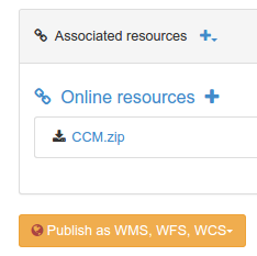
#. Choose a resource from the list to display the wizard. The wizard display the list of map servers available:
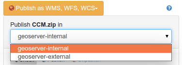
#. Choose the server you want to publish the data in. When selected, the catalog will check if the dataset is already published.
如果找到,它会被添加到地图中。。图::img/geopublication向导-打开.png
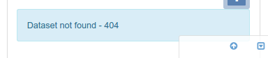
否则,状态消息指示数据集不可用。
从菜单中,控制发布过程:

单击
check按钮以验证数据集已在选定的映射服务器中发布。单击
publish按钮在选定的地图服务器上注册数据。单击
unpublish按钮在选定的地图服务器上注销数据。单击
link service to metadata按钮,在已发布层的当前元数据记录中添加到OGC服务的链接。
下一步
在元数据记录中注册WMS层后,可以使用该服务生成概述(请参见 使用WMS层生成缩略图 )