地理信息特征编目方法(iso19110)
更多细节:http://www.iso.org/iso/home/store/catalogue-tc/catalogue-detail.htm?C编号=39965
元数据编辑器
此标准可以使用3个视图进行编码。
视图:简单(默认)
此视图由个表组成。
即使不在当前记录中,此视图也允许添加以下元素:
代码(gfc:代码)
代码表(gfc:listedValue)
选项卡:简单(默认)
此选项卡显示XML元数据记录中的元素。
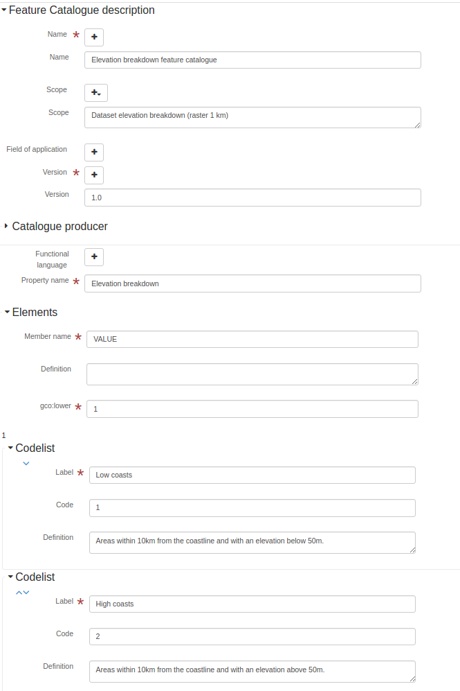
章节:功能目录说明
见:参考:iso19110-elem-gfc-FC特性目录-A4DE44FDD9A6E86E8BA63BB96BE363C
名字
Feature catalogue name- XPath
/gfc:FC_功能目录/gmx:名称
见:参考:iso19110-elem-gmx-name-5ec0c4442ad2b949446103e556d401
名字
Feature catalogue name- XPath
/gfc:FC_功能目录/gfc:名称
见:参考:iso19110-elem-gfc-name-134285dc9b9a3268556039e2fe3f370e
范围
Scope definition- XPath
/gfc:FC_功能目录/gmx:范围
见:参考:iso19110-elem-gmx-scope-14efac6982297b09ba1324e80138092f
范围
Scope definition- XPath
/gfc:FC_功能目录/gfc:范围
见:参考:iso19110-elem-gfc-scope-4f044fce55b8e0b6dd0d77516ad9e66d
应用领域
Field of application- XPath
/gfc:FC_功能目录/gmx:应用程序字段
见:参考:iso19110-elem-gmx-fieldOfApplication-66508d1f139317e01decd09915428
应用领域
Field of application- XPath
/gfc:FC_功能目录/gfc:应用程序字段
见:参考:iso19110-elem-gfc-fieldOfApplication-548e0631e3ea92f7dd05ac533b6c14d2
版本
Catalogue version- XPath
/gfc:FC_功能目录/gmx:版本号
见:参考:iso19110-elem-gmx-版本号-075201f18225aec432b46c75a93589a2
版本
Catalogue version- XPath
/gfc:FC_功能目录/gfc:版本号
见:参考:iso19110-elem-gfc-版本号-d66ec9fd5c22c70a69dd2b759d66cc4f
日期
Catalogue date- XPath
/gfc:FC_功能目录/gmx:版本日期
见:参考:iso19110-elem-gmx-versionDate-6c27e2ee0b2daa4ab1ae9ef374bc08f
目录制作人
Catalogue responsible- XPath
/gfc:FC_功能目录/gfc:制作人
见:参考:iso19110-elem-gfc-producer-5a13bfab8b07441bc9f9f71dcfdf7f6c
功能语言
- XPath
/gfc:FC_功能目录/gfc:功能术语
见:参考:iso19110-elem-gfc-功能表-7a21d9c35ed9c400c40959ed97b8d76
属性描述
Property description- XPath
/gfc:FC_功能目录/gfc:功能类型
见:参考:iso19110-elem-gfc-featureType-d6099a684b15337451388dd46048c48f
- 类型
建议
视图:完全(高级)
此视图由个表组成。
选项卡:完全(高级)
此选项卡显示XML元数据记录中的元素,还提供控件以添加架构(XSD)中定义的所有元素。
节:属性表说明
Attribute table description见:参考:iso19110-elem-gfc-FC_特征类型-38ad06d5e87d9bf33d5f11e7bca0eb4
章节:功能目录说明
见:参考:iso19110-elem-gfc-FC特性目录-A4DE44FDD9A6E86E8BA63BB96BE363C
视图:XML(XML)
此视图由个表组成。
选项卡:XML(XML)
此选项卡显示XML元数据记录中的元素,还提供控件以添加架构(XSD)中定义的所有元素。
架构技术详细信息
- 标准标识符
国际标准组织19110
- 版本
1.0
- 架构位置
http://www.isotc211.org/2005/gfc http://www.isotc211.org/2005/gfc/gfc.xsd
- 架构命名空间
- 架构检测模式
元素(根)
- 架构检测元素
gfc:FC_特色目录
gfc:FC_功能类型
标准元素
标准中所有可用元素的列表。
文本
- 名字
gco:字符字符串
- 描述
低基数
- 名字
gco:较低
- 描述
<gco:lower xmlns:gfc="http://www.isotc211.org/2005/gfc"
           xmlns:xsi="http://www.w3.org/2001/XMLSchema-instance">
   <gco:Integer>1</gco:Integer>
</gco:lower>
无理由
- 名字
gco:无理由
- 描述
范围
- 名字
gco:范围
- 描述
<gco:range xmlns:gfc="http://www.isotc211.org/2005/gfc"
           xmlns:xsi="http://www.w3.org/2001/XMLSchema-instance">
   <gco:MultiplicityRange>
      <gco:lower>
         <gco:Integer>1</gco:Integer>
      </gco:lower>
      <gco:upper>
         <gco:UnlimitedInteger isInfinite="false" xsi:nil="false">1
                    </gco:UnlimitedInteger>
      </gco:upper>
   </gco:MultiplicityRange>
</gco:range>
上基数
- 名字
gco:上部
- 描述
<gco:upper xmlns:gfc="http://www.isotc211.org/2005/gfc"
           xmlns:xsi="http://www.w3.org/2001/XMLSchema-instance">
   <gco:UnlimitedInteger isInfinite="false" xsi:nil="false">1
                    </gco:UnlimitedInteger>
</gco:upper>
影响价值
- 名字
gfc:影响值
- 描述
别名
- 名字
gfc:别名
- 描述
基数
- 名字
gfc:基数
- 描述
<gfc:cardinality xmlns:gfc="http://www.isotc211.org/2005/gfc"
                 xmlns:xsi="http://www.w3.org/2001/XMLSchema-instance">
   <gco:Multiplicity>
      <gco:range>
         <gco:MultiplicityRange>
            <gco:lower>
               <gco:Integer>1</gco:Integer>
            </gco:lower>
            <gco:upper>
               <gco:UnlimitedInteger isInfinite="false" xsi:nil="false">1
                    </gco:UnlimitedInteger>
            </gco:upper>
         </gco:MultiplicityRange>
      </gco:range>
   </gco:Multiplicity>
</gfc:cardinality>
元素
- 名字
gfc:载体特性
- 描述
<gfc:carrierOfCharacteristics xmlns:gfc="http://www.isotc211.org/2005/gfc"
                              xmlns:xsi="http://www.w3.org/2001/XMLSchema-instance">
   <gfc:FC_FeatureAttribute>
      <gfc:memberName>
         <gco:LocalName>VALUE</gco:LocalName>
      </gfc:memberName>
      <gfc:definition>
         <gco:CharacterString/>
      </gfc:definition>
      <gfc:cardinality>
         <gco:Multiplicity>
            <gco:range>
               <gco:MultiplicityRange>
                  <gco:lower>
                     <gco:Integer>1</gco:Integer>
                  </gco:lower>
                  <gco:upper>
                     <gco:UnlimitedInteger isInfinite="false" xsi:nil="false">1
                    </gco:UnlimitedInteger>
                  </gco:upper>
               </gco:MultiplicityRange>
            </gco:range>
         </gco:Multiplicity>
      </gfc:cardinality>
      <gfc:featureType/>
      <gfc:valueMeasurementUnit>
         <gml:UnitDefinition xmlns:gml="http://www.opengis.net/gml" gml:id="unknown">
            <gml:description/>
            <gml:identifier codeSpace="unknown"/>
         </gml:UnitDefinition>
      </gfc:valueMeasurementUnit>
      <gfc:listedValue>
         <gfc:FC_ListedValue>
            <gfc:label>
               <gco:CharacterString>Low coasts</gco:CharacterString>
            </gfc:label>
            <gfc:code>
               <gco:CharacterString>1</gco:CharacterString>
            </gfc:code>
            <gfc:definition>
               <gco:CharacterString>Areas within 10km from the coastline and with an elevation
                  below 50m.
                </gco:CharacterString>
            </gfc:definition>
         </gfc:FC_ListedValue>
      </gfc:listedValue>
      <gfc:listedValue>
         <gfc:FC_ListedValue>
            <gfc:label>
               <gco:CharacterString>High coasts</gco:CharacterString>
            </gfc:label>
            <gfc:code>
               <gco:CharacterString>2</gco:CharacterString>
            </gfc:code>
            <gfc:definition>
               <gco:CharacterString>Areas within 10km from the coastline and with an elevation
                  above 50m.
                </gco:CharacterString>
            </gfc:definition>
         </gfc:FC_ListedValue>
      </gfc:listedValue>
      <gfc:listedValue>
         <gfc:FC_ListedValue>
            <gfc:label>
               <gco:CharacterString>Inlands</gco:CharacterString>
            </gfc:label>
            <gfc:code>
               <gco:CharacterString>3</gco:CharacterString>
            </gfc:code>
            <gfc:definition>
               <gco:CharacterString>Areas between 0 and 200 m outside the coastal strip.
                </gco:CharacterString>
            </gfc:definition>
         </gfc:FC_ListedValue>
      </gfc:listedValue>
      <gfc:listedValue>
         <gfc:FC_ListedValue>
            <gfc:label>
               <gco:CharacterString>Uplands</gco:CharacterString>
            </gfc:label>
            <gfc:code>
               <gco:CharacterString>4</gco:CharacterString>
            </gfc:code>
            <gfc:definition>
               <gco:CharacterString>Zones between 200 and 500 m plus the flat areas between 500 and
                  1000m.
                </gco:CharacterString>
            </gfc:definition>
         </gfc:FC_ListedValue>
      </gfc:listedValue>
      <gfc:listedValue>
         <gfc:FC_ListedValue>
            <gfc:label>
               <gco:CharacterString>Mountains</gco:CharacterString>
            </gfc:label>
            <gfc:code>
               <gco:CharacterString>5</gco:CharacterString>
            </gfc:code>
            <gfc:definition>
               <gco:CharacterString>Slopy areas between 500 and 1000m and all the areas over
                  1000m.
                </gco:CharacterString>
            </gfc:definition>
         </gfc:FC_ListedValue>
      </gfc:listedValue>
      <gfc:valueType>
         <gco:TypeName>
            <gco:aName>
               <gco:CharacterString>INTEGER</gco:CharacterString>
            </gco:aName>
         </gco:TypeName>
      </gfc:valueType>
   </gfc:FC_FeatureAttribute>
</gfc:carrierOfCharacteristics>
代码
- 名字
gfc:代码
- 描述
约束条件
- 名字
gfc:约束
- 描述
定义
- 名字
gfc:定义
- 描述
定义引用
- 名字
gfc:定义参考
- 描述
定义源
- 名字
gfc:定义源
- 描述
描述
- 名字
gfc:描述
- 描述
关联角色
- 名字
gfc:FC_协会角色
- 描述
约束
- 名字
gfc:FC_约束
- 描述
特征关联
- 名字
gfc:FC_特性协会
- 描述
属性
- 名字
gfc:FC_功能属性
- 描述
<gfc:FC_FeatureAttribute xmlns:gfc="http://www.isotc211.org/2005/gfc"
                         xmlns:xsi="http://www.w3.org/2001/XMLSchema-instance">
   <gfc:memberName>
      <gco:LocalName>VALUE</gco:LocalName>
   </gfc:memberName>
   <gfc:definition>
      <gco:CharacterString/>
   </gfc:definition>
   <gfc:cardinality>
      <gco:Multiplicity>
         <gco:range>
            <gco:MultiplicityRange>
               <gco:lower>
                  <gco:Integer>1</gco:Integer>
               </gco:lower>
               <gco:upper>
                  <gco:UnlimitedInteger isInfinite="false" xsi:nil="false">1
                    </gco:UnlimitedInteger>
               </gco:upper>
            </gco:MultiplicityRange>
         </gco:range>
      </gco:Multiplicity>
   </gfc:cardinality>
   <gfc:featureType/>
   <gfc:valueMeasurementUnit>
      <gml:UnitDefinition xmlns:gml="http://www.opengis.net/gml" gml:id="unknown">
         <gml:description/>
         <gml:identifier codeSpace="unknown"/>
      </gml:UnitDefinition>
   </gfc:valueMeasurementUnit>
   <gfc:listedValue>
      <gfc:FC_ListedValue>
         <gfc:label>
            <gco:CharacterString>Low coasts</gco:CharacterString>
         </gfc:label>
         <gfc:code>
            <gco:CharacterString>1</gco:CharacterString>
         </gfc:code>
         <gfc:definition>
            <gco:CharacterString>Areas within 10km from the coastline and with an elevation
                  below 50m.
                </gco:CharacterString>
         </gfc:definition>
      </gfc:FC_ListedValue>
   </gfc:listedValue>
   <gfc:listedValue>
      <gfc:FC_ListedValue>
         <gfc:label>
            <gco:CharacterString>High coasts</gco:CharacterString>
         </gfc:label>
         <gfc:code>
            <gco:CharacterString>2</gco:CharacterString>
         </gfc:code>
         <gfc:definition>
            <gco:CharacterString>Areas within 10km from the coastline and with an elevation
                  above 50m.
                </gco:CharacterString>
         </gfc:definition>
      </gfc:FC_ListedValue>
   </gfc:listedValue>
   <gfc:listedValue>
      <gfc:FC_ListedValue>
         <gfc:label>
            <gco:CharacterString>Inlands</gco:CharacterString>
         </gfc:label>
         <gfc:code>
            <gco:CharacterString>3</gco:CharacterString>
         </gfc:code>
         <gfc:definition>
            <gco:CharacterString>Areas between 0 and 200 m outside the coastal strip.
                </gco:CharacterString>
         </gfc:definition>
      </gfc:FC_ListedValue>
   </gfc:listedValue>
   <gfc:listedValue>
      <gfc:FC_ListedValue>
         <gfc:label>
            <gco:CharacterString>Uplands</gco:CharacterString>
         </gfc:label>
         <gfc:code>
            <gco:CharacterString>4</gco:CharacterString>
         </gfc:code>
         <gfc:definition>
            <gco:CharacterString>Zones between 200 and 500 m plus the flat areas between 500 and
                  1000m.
                </gco:CharacterString>
         </gfc:definition>
      </gfc:FC_ListedValue>
   </gfc:listedValue>
   <gfc:listedValue>
      <gfc:FC_ListedValue>
         <gfc:label>
            <gco:CharacterString>Mountains</gco:CharacterString>
         </gfc:label>
         <gfc:code>
            <gco:CharacterString>5</gco:CharacterString>
         </gfc:code>
         <gfc:definition>
            <gco:CharacterString>Slopy areas between 500 and 1000m and all the areas over
                  1000m.
                </gco:CharacterString>
         </gfc:definition>
      </gfc:FC_ListedValue>
   </gfc:listedValue>
   <gfc:valueType>
      <gco:TypeName>
         <gco:aName>
            <gco:CharacterString>INTEGER</gco:CharacterString>
         </gco:aName>
      </gco:TypeName>
   </gfc:valueType>
</gfc:FC_FeatureAttribute>
功能目录说明
- 名字
gfc:FC_特色目录
- 描述
<gfc:FC_FeatureCatalogue xmlns:gfc="http://www.isotc211.org/2005/gfc"
                         uuid="411cd05b-9a79-45f2-b39f-0b344a9f35af"
                         xsi:schemaLocation="http://www.isotc211.org/2005/gfc http://www.isotc211.org/2005/gfc/gfc.xsd">
   <gfc:name>
      <gco:CharacterString>Elevation breakdown feature catalogue</gco:CharacterString>
   </gfc:name>
   <gfc:scope>
      <gco:CharacterString>Dataset elevation breakdown (raster 1 km)</gco:CharacterString>
   </gfc:scope>
   <gfc:versionNumber>
      <gco:CharacterString>1.0</gco:CharacterString>
   </gfc:versionNumber>
   <gfc:versionDate>
      <gco:DateTime>2012-11-05T10:56:11</gco:DateTime>
   </gfc:versionDate>
   <gfc:producer>
      <gmd:CI_ResponsibleParty>
         <gmd:individualName>
            <gco:CharacterString>European Environment Agency</gco:CharacterString>
         </gmd:individualName>
         <gmd:organisationName>
            <gco:CharacterString/>
         </gmd:organisationName>
         <gmd:positionName>
            <gco:CharacterString/>
         </gmd:positionName>
         <gmd:contactInfo>
            <gmd:CI_Contact>
               <gmd:address>
                  <gmd:CI_Address>
                     <gmd:deliveryPoint>
                        <gco:CharacterString>Kongens Nytorv 6</gco:CharacterString>
                     </gmd:deliveryPoint>
                     <gmd:city>
                        <gco:CharacterString>Copenhagen</gco:CharacterString>
                     </gmd:city>
                     <gmd:administrativeArea>
                        <gco:CharacterString>K</gco:CharacterString>
                     </gmd:administrativeArea>
                     <gmd:postalCode>
                        <gco:CharacterString>1050</gco:CharacterString>
                     </gmd:postalCode>
                     <gmd:country>
                        <gco:CharacterString>Denmark</gco:CharacterString>
                     </gmd:country>
                     <gmd:electronicMailAddress>
                        <gco:CharacterString>mauro.michielon@eea.europa.eu</gco:CharacterString>
                     </gmd:electronicMailAddress>
                  </gmd:CI_Address>
               </gmd:address>
            </gmd:CI_Contact>
         </gmd:contactInfo>
         <gmd:role>
            <gmd:CI_RoleCode codeListValue="pointOfContact" codeList="CI_RoleCode"/>
         </gmd:role>
      </gmd:CI_ResponsibleParty>
   </gfc:producer>
   <gfc:featureType>
      <gfc:FC_FeatureType>
         <gfc:typeName>
            <gco:LocalName>Elevation breakdown</gco:LocalName>
         </gfc:typeName>
         <gfc:definition>
            <gco:CharacterString>The Elevation breakdown is used to allocate Land cover changes into
          homogeneous areas as function of height, slope and distance to the sea.
        </gco:CharacterString>
         </gfc:definition>
         <gfc:isAbstract>
            <gco:Boolean>false</gco:Boolean>
         </gfc:isAbstract>
         <gfc:featureCatalogue/>
         <gfc:carrierOfCharacteristics>
            <gfc:FC_FeatureAttribute>
               <gfc:memberName>
                  <gco:LocalName>VALUE</gco:LocalName>
               </gfc:memberName>
               <gfc:definition>
                  <gco:CharacterString/>
               </gfc:definition>
               <gfc:cardinality>
                  <gco:Multiplicity>
                     <gco:range>
                        <gco:MultiplicityRange>
                           <gco:lower>
                              <gco:Integer>1</gco:Integer>
                           </gco:lower>
                           <gco:upper>
                              <gco:UnlimitedInteger isInfinite="false" xsi:nil="false">1
                    </gco:UnlimitedInteger>
                           </gco:upper>
                        </gco:MultiplicityRange>
                     </gco:range>
                  </gco:Multiplicity>
               </gfc:cardinality>
               <gfc:featureType/>
               <gfc:valueMeasurementUnit>
                  <gml:UnitDefinition xmlns:gml="http://www.opengis.net/gml" gml:id="unknown">
                     <gml:description/>
                     <gml:identifier codeSpace="unknown"/>
                  </gml:UnitDefinition>
               </gfc:valueMeasurementUnit>
               <gfc:listedValue>
                  <gfc:FC_ListedValue>
                     <gfc:label>
                        <gco:CharacterString>Low coasts</gco:CharacterString>
                     </gfc:label>
                     <gfc:code>
                        <gco:CharacterString>1</gco:CharacterString>
                     </gfc:code>
                     <gfc:definition>
                        <gco:CharacterString>Areas within 10km from the coastline and with an elevation
                  below 50m.
                </gco:CharacterString>
                     </gfc:definition>
                  </gfc:FC_ListedValue>
               </gfc:listedValue>
               <gfc:listedValue>
                  <gfc:FC_ListedValue>
                     <gfc:label>
                        <gco:CharacterString>High coasts</gco:CharacterString>
                     </gfc:label>
                     <gfc:code>
                        <gco:CharacterString>2</gco:CharacterString>
                     </gfc:code>
                     <gfc:definition>
                        <gco:CharacterString>Areas within 10km from the coastline and with an elevation
                  above 50m.
                </gco:CharacterString>
                     </gfc:definition>
                  </gfc:FC_ListedValue>
               </gfc:listedValue>
               <gfc:listedValue>
                  <gfc:FC_ListedValue>
                     <gfc:label>
                        <gco:CharacterString>Inlands</gco:CharacterString>
                     </gfc:label>
                     <gfc:code>
                        <gco:CharacterString>3</gco:CharacterString>
                     </gfc:code>
                     <gfc:definition>
                        <gco:CharacterString>Areas between 0 and 200 m outside the coastal strip.
                </gco:CharacterString>
                     </gfc:definition>
                  </gfc:FC_ListedValue>
               </gfc:listedValue>
               <gfc:listedValue>
                  <gfc:FC_ListedValue>
                     <gfc:label>
                        <gco:CharacterString>Uplands</gco:CharacterString>
                     </gfc:label>
                     <gfc:code>
                        <gco:CharacterString>4</gco:CharacterString>
                     </gfc:code>
                     <gfc:definition>
                        <gco:CharacterString>Zones between 200 and 500 m plus the flat areas between 500 and
                  1000m.
                </gco:CharacterString>
                     </gfc:definition>
                  </gfc:FC_ListedValue>
               </gfc:listedValue>
               <gfc:listedValue>
                  <gfc:FC_ListedValue>
                     <gfc:label>
                        <gco:CharacterString>Mountains</gco:CharacterString>
                     </gfc:label>
                     <gfc:code>
                        <gco:CharacterString>5</gco:CharacterString>
                     </gfc:code>
                     <gfc:definition>
                        <gco:CharacterString>Slopy areas between 500 and 1000m and all the areas over
                  1000m.
                </gco:CharacterString>
                     </gfc:definition>
                  </gfc:FC_ListedValue>
               </gfc:listedValue>
               <gfc:valueType>
                  <gco:TypeName>
                     <gco:aName>
                        <gco:CharacterString>INTEGER</gco:CharacterString>
                     </gco:aName>
                  </gco:TypeName>
               </gfc:valueType>
            </gfc:FC_FeatureAttribute>
         </gfc:carrierOfCharacteristics>
      </gfc:FC_FeatureType>
   </gfc:featureType>
</gfc:FC_FeatureCatalogue>
特征运算
- 名字
gfc:FC_特性操作
- 描述
属性表说明
- 名字
gfc:FC_功能类型
- 描述
<gfc:FC_FeatureType xmlns:gfc="http://www.isotc211.org/2005/gfc"
                    xmlns:xsi="http://www.w3.org/2001/XMLSchema-instance">
   <gfc:typeName>
      <gco:LocalName>Elevation breakdown</gco:LocalName>
   </gfc:typeName>
   <gfc:definition>
      <gco:CharacterString>The Elevation breakdown is used to allocate Land cover changes into
          homogeneous areas as function of height, slope and distance to the sea.
        </gco:CharacterString>
   </gfc:definition>
   <gfc:isAbstract>
      <gco:Boolean>false</gco:Boolean>
   </gfc:isAbstract>
   <gfc:featureCatalogue/>
   <gfc:carrierOfCharacteristics>
      <gfc:FC_FeatureAttribute>
         <gfc:memberName>
            <gco:LocalName>VALUE</gco:LocalName>
         </gfc:memberName>
         <gfc:definition>
            <gco:CharacterString/>
         </gfc:definition>
         <gfc:cardinality>
            <gco:Multiplicity>
               <gco:range>
                  <gco:MultiplicityRange>
                     <gco:lower>
                        <gco:Integer>1</gco:Integer>
                     </gco:lower>
                     <gco:upper>
                        <gco:UnlimitedInteger isInfinite="false" xsi:nil="false">1
                    </gco:UnlimitedInteger>
                     </gco:upper>
                  </gco:MultiplicityRange>
               </gco:range>
            </gco:Multiplicity>
         </gfc:cardinality>
         <gfc:featureType/>
         <gfc:valueMeasurementUnit>
            <gml:UnitDefinition xmlns:gml="http://www.opengis.net/gml" gml:id="unknown">
               <gml:description/>
               <gml:identifier codeSpace="unknown"/>
            </gml:UnitDefinition>
         </gfc:valueMeasurementUnit>
         <gfc:listedValue>
            <gfc:FC_ListedValue>
               <gfc:label>
                  <gco:CharacterString>Low coasts</gco:CharacterString>
               </gfc:label>
               <gfc:code>
                  <gco:CharacterString>1</gco:CharacterString>
               </gfc:code>
               <gfc:definition>
                  <gco:CharacterString>Areas within 10km from the coastline and with an elevation
                  below 50m.
                </gco:CharacterString>
               </gfc:definition>
            </gfc:FC_ListedValue>
         </gfc:listedValue>
         <gfc:listedValue>
            <gfc:FC_ListedValue>
               <gfc:label>
                  <gco:CharacterString>High coasts</gco:CharacterString>
               </gfc:label>
               <gfc:code>
                  <gco:CharacterString>2</gco:CharacterString>
               </gfc:code>
               <gfc:definition>
                  <gco:CharacterString>Areas within 10km from the coastline and with an elevation
                  above 50m.
                </gco:CharacterString>
               </gfc:definition>
            </gfc:FC_ListedValue>
         </gfc:listedValue>
         <gfc:listedValue>
            <gfc:FC_ListedValue>
               <gfc:label>
                  <gco:CharacterString>Inlands</gco:CharacterString>
               </gfc:label>
               <gfc:code>
                  <gco:CharacterString>3</gco:CharacterString>
               </gfc:code>
               <gfc:definition>
                  <gco:CharacterString>Areas between 0 and 200 m outside the coastal strip.
                </gco:CharacterString>
               </gfc:definition>
            </gfc:FC_ListedValue>
         </gfc:listedValue>
         <gfc:listedValue>
            <gfc:FC_ListedValue>
               <gfc:label>
                  <gco:CharacterString>Uplands</gco:CharacterString>
               </gfc:label>
               <gfc:code>
                  <gco:CharacterString>4</gco:CharacterString>
               </gfc:code>
               <gfc:definition>
                  <gco:CharacterString>Zones between 200 and 500 m plus the flat areas between 500 and
                  1000m.
                </gco:CharacterString>
               </gfc:definition>
            </gfc:FC_ListedValue>
         </gfc:listedValue>
         <gfc:listedValue>
            <gfc:FC_ListedValue>
               <gfc:label>
                  <gco:CharacterString>Mountains</gco:CharacterString>
               </gfc:label>
               <gfc:code>
                  <gco:CharacterString>5</gco:CharacterString>
               </gfc:code>
               <gfc:definition>
                  <gco:CharacterString>Slopy areas between 500 and 1000m and all the areas over
                  1000m.
                </gco:CharacterString>
               </gfc:definition>
            </gfc:FC_ListedValue>
         </gfc:listedValue>
         <gfc:valueType>
            <gco:TypeName>
               <gco:aName>
                  <gco:CharacterString>INTEGER</gco:CharacterString>
               </gco:aName>
            </gco:TypeName>
         </gfc:valueType>
      </gfc:FC_FeatureAttribute>
   </gfc:carrierOfCharacteristics>
</gfc:FC_FeatureType>
遗传关系
- 名字
gfc:FC_继承关系
- 描述
代码表
- 名字
gfc:FC_ListedValue
- 描述
角色类型
- 名字
gfc:FC_角色类型
- 描述
专题目录
- 名字
gfc:功能目录
- 描述
<gfc:featureCatalogue xmlns:gfc="http://www.isotc211.org/2005/gfc"
                      xmlns:xsi="http://www.w3.org/2001/XMLSchema-instance"/>
属性描述
- 名字
gfc:特性类型
- 描述
应用领域
- 名字
gfc:应用领域
- 描述
形式定义
- 名字
gfc:形式定义
- 描述
功能语言
- 名字
gfc:功能语言
- 描述
继承自
- 名字
gfc:继承自
- 描述
继承
- 名字
gfc:继承
- 描述
摘要
- 名字
gfc:isAbstract公司
- 描述
<gfc:isAbstract xmlns:gfc="http://www.isotc211.org/2005/gfc"
                xmlns:xsi="http://www.w3.org/2001/XMLSchema-instance">
   <gco:Boolean>false</gco:Boolean>
</gfc:isAbstract>
被命令
- 名字
gfc:等序
- 描述
标签
- 名字
gfc:标签
- 描述
代码表
- 名字
gfc:listedValue
- 描述
成员名称
- 名字
gfc:成员名称
- 描述
<gfc:memberName xmlns:gfc="http://www.isotc211.org/2005/gfc"
                xmlns:xsi="http://www.w3.org/2001/XMLSchema-instance">
   <gco:LocalName>VALUE</gco:LocalName>
</gfc:memberName>
名字
- 名字
gfc:名称
- 描述
<gfc:name xmlns:gfc="http://www.isotc211.org/2005/gfc"
          xmlns:xsi="http://www.w3.org/2001/XMLSchema-instance">
   <gco:CharacterString>Elevation breakdown feature catalogue</gco:CharacterString>
</gfc:name>
观察的价值
- 名字
gfc:观测值
- 描述
目录制作人
- 名字
gfc:生产商
- 描述
<gfc:producer xmlns:gfc="http://www.isotc211.org/2005/gfc"
              xmlns:xsi="http://www.w3.org/2001/XMLSchema-instance">
   <gmd:CI_ResponsibleParty>
      <gmd:individualName>
         <gco:CharacterString>European Environment Agency</gco:CharacterString>
      </gmd:individualName>
      <gmd:organisationName>
         <gco:CharacterString/>
      </gmd:organisationName>
      <gmd:positionName>
         <gco:CharacterString/>
      </gmd:positionName>
      <gmd:contactInfo>
         <gmd:CI_Contact>
            <gmd:address>
               <gmd:CI_Address>
                  <gmd:deliveryPoint>
                     <gco:CharacterString>Kongens Nytorv 6</gco:CharacterString>
                  </gmd:deliveryPoint>
                  <gmd:city>
                     <gco:CharacterString>Copenhagen</gco:CharacterString>
                  </gmd:city>
                  <gmd:administrativeArea>
                     <gco:CharacterString>K</gco:CharacterString>
                  </gmd:administrativeArea>
                  <gmd:postalCode>
                     <gco:CharacterString>1050</gco:CharacterString>
                  </gmd:postalCode>
                  <gmd:country>
                     <gco:CharacterString>Denmark</gco:CharacterString>
                  </gmd:country>
                  <gmd:electronicMailAddress>
                     <gco:CharacterString>mauro.michielon@eea.europa.eu</gco:CharacterString>
                  </gmd:electronicMailAddress>
               </gmd:CI_Address>
            </gmd:address>
         </gmd:CI_Contact>
      </gmd:contactInfo>
      <gmd:role>
         <gmd:CI_RoleCode codeListValue="pointOfContact" codeList="CI_RoleCode"/>
      </gmd:role>
   </gmd:CI_ResponsibleParty>
</gfc:producer>
关系
- 名字
gfc:关系
- 描述
角色名称
- 名字
绿色荧光粉:roleName
- 描述
角色类型
- 名字
绿色荧光粉:roleType
- 描述
范围
- 名字
gfc:范围
- 描述
<gfc:scope xmlns:gfc="http://www.isotc211.org/2005/gfc"
           xmlns:xsi="http://www.w3.org/2001/XMLSchema-instance">
   <gco:CharacterString>Dataset elevation breakdown (raster 1 km)</gco:CharacterString>
</gfc:scope>
签名
- 名字
gfc:签名
- 描述
由值触发
- 名字
gfc:triggeredByValueOf
- 描述
类型
- 名字
gfc:类型
- 描述
物业名称
- 名字
gfc:类型名
- 描述
<gfc:typeName xmlns:gfc="http://www.isotc211.org/2005/gfc"
              xmlns:xsi="http://www.w3.org/2001/XMLSchema-instance">
   <gco:LocalName>Elevation breakdown</gco:LocalName>
</gfc:typeName>
唯一实例
- 名字
gfc:唯一实例
- 描述
价值计量单位
- 名字
gfc:价值计量
- 描述
<gfc:valueMeasurementUnit xmlns:gfc="http://www.isotc211.org/2005/gfc"
                          xmlns:xsi="http://www.w3.org/2001/XMLSchema-instance">
   <gml:UnitDefinition xmlns:gml="http://www.opengis.net/gml" gml:id="unknown">
      <gml:description/>
      <gml:identifier codeSpace="unknown"/>
   </gml:UnitDefinition>
</gfc:valueMeasurementUnit>
值类型
- 名字
gfc:值类型
- 描述
<gfc:valueType xmlns:gfc="http://www.isotc211.org/2005/gfc"
               xmlns:xsi="http://www.w3.org/2001/XMLSchema-instance">
   <gco:TypeName>
      <gco:aName>
         <gco:CharacterString>INTEGER</gco:CharacterString>
      </gco:aName>
   </gco:TypeName>
</gfc:valueType>
日期
- 名字
gfc:云芝
- 描述
<gfc:versionDate xmlns:gfc="http://www.isotc211.org/2005/gfc"
                 xmlns:xsi="http://www.w3.org/2001/XMLSchema-instance">
   <gco:DateTime>2012-11-05T10:56:11</gco:DateTime>
</gfc:versionDate>
版本
- 名字
gfc:版本号
- 描述
<gfc:versionNumber xmlns:gfc="http://www.isotc211.org/2005/gfc"
                   xmlns:xsi="http://www.w3.org/2001/XMLSchema-instance">
   <gco:CharacterString>1.0</gco:CharacterString>
</gfc:versionNumber>
责任方
- 名字
gmd:CI_责任方
- 描述
<gmd:CI_ResponsibleParty xmlns:gfc="http://www.isotc211.org/2005/gfc"
                         xmlns:xsi="http://www.w3.org/2001/XMLSchema-instance">
   <gmd:individualName>
      <gco:CharacterString>European Environment Agency</gco:CharacterString>
   </gmd:individualName>
   <gmd:organisationName>
      <gco:CharacterString/>
   </gmd:organisationName>
   <gmd:positionName>
      <gco:CharacterString/>
   </gmd:positionName>
   <gmd:contactInfo>
      <gmd:CI_Contact>
         <gmd:address>
            <gmd:CI_Address>
               <gmd:deliveryPoint>
                  <gco:CharacterString>Kongens Nytorv 6</gco:CharacterString>
               </gmd:deliveryPoint>
               <gmd:city>
                  <gco:CharacterString>Copenhagen</gco:CharacterString>
               </gmd:city>
               <gmd:administrativeArea>
                  <gco:CharacterString>K</gco:CharacterString>
               </gmd:administrativeArea>
               <gmd:postalCode>
                  <gco:CharacterString>1050</gco:CharacterString>
               </gmd:postalCode>
               <gmd:country>
                  <gco:CharacterString>Denmark</gco:CharacterString>
               </gmd:country>
               <gmd:electronicMailAddress>
                  <gco:CharacterString>mauro.michielon@eea.europa.eu</gco:CharacterString>
               </gmd:electronicMailAddress>
            </gmd:CI_Address>
         </gmd:address>
      </gmd:CI_Contact>
   </gmd:contactInfo>
   <gmd:role>
      <gmd:CI_RoleCode codeListValue="pointOfContact" codeList="CI_RoleCode"/>
   </gmd:role>
</gmd:CI_ResponsibleParty>
责任方
- 名字
gmd:责任方
- 描述
锚
- 名字
gmx:锚
- 描述
应用领域
- 名字
gmx:应用领域
- 描述
文件名
- 名字
gmx:文件名
- 描述
名字
- 名字
gmx:名称
- 描述
范围
- 名字
gmx:范围
- 描述
日期
- 名字
gmx:版本号
- 描述
版本
- 名字
gmx:版本号
- 描述
标准代码表
标准中所有可用代码列表的列表。
未定义代码列表。