地理信息元数据(iso19139-2007)(iso19139)
ISO 19115定义了用元数据描述地理信息和服务所需的模式。它提供有关数字地理数据和服务的标识、范围、质量、空间和时间方面、内容、空间参考、描绘、分布和其他特性的信息。
ISO 19115适用于:
所有类型资源的编目、票据交换所活动以及数据集和服务的完整描述;
地理数据集和地理特性。
ISO 19115定义:
强制和条件元数据节、元数据实体和元数据元素;
为大多数元数据应用程序(数据发现、确定数据适用性、数据访问、数据传输以及数字数据和服务的使用)提供服务所需的最小元数据集;
可选元数据元素,以便在需要时对资源进行更广泛的标准描述;
一种扩展元数据以满足特殊需要的方法。
尽管ISO 19115适用于数字数据和服务,但其原则可以扩展到许多其他类型的资源,如地图、图表、文本文档以及非地理数据。某些条件元数据元素可能不适用于这些其他形式的数据。
更多详细信息:https://www.iso.org/iso/home/store/catalogue-tc/catalogue-detail.htm?C编号=53798
元数据编辑器
此标准可以使用3个视图进行编码。
视图:简单(默认)
此视图由个表组成。
即使不在当前记录中,此视图也允许添加以下元素:
描述性关键字(gmd:描述关键字)
关键字(gmd:关键字)
空间分辨率(gmd:空间分辨率)
接触点(gmd:接触点)
分销商(gmd:经销商)
分发格式(gmd:分布式格式)
接触(gmd:联系人)
处理器(gmd:处理器)
主题类别(gmd:主题类别)
参数(srv:参数)
选项卡:简单(默认)
此选项卡显示XML元数据记录中的元素。
章节:识别信息
Basic information about the resource(s) to which the metadata applies见:参考:iso19139-elem-gmd-identificationInfo-4fe68a205ff13feeccf0b58e08f39472
章节:参考系统信息
Description of the spatial and temporal reference systems used in the dataset见:参考:iso19139-elem-gmd-referenceSystemInfo-c7702a2e8ac03097e306ab3a02406765
节:空间表示信息
Digital representation of spatial information in the dataset见:参考:iso19139-elem-gmd-spacerepresentationinfo-f93705d4877ccd4c41819cc79677d6f2
章节:分发信息
Provides information about the distributor of and options for obtaining the resource(s)见:参考:iso19139-elem-gmd-distributionInfo-3bddab6fda29c9ebd6f0ece68843fcff
章节:数据质量信息
Provides overall assessment of quality of a resource(s)见:参考:iso19139-elem-gmd-dataQualityInfo-9a53c25e2dacf5a7ab0aa1d155efc3dc
节:内容信息
Provides information about the feature catalogue and describes the coverage and image data characteristics见:参考:iso19139-elem-gmd-contentInfo-da18cd6a5e91bae67187adc15ff47622
节:元数据
Root entity which defines metadata about a resource or resources见:参考:iso19139-elem-gmd-MD U元数据-c2690d5de6984085623477c3bdc3275b
文件标识符
Unique identifier for this metadata file- XPath
/gmd:MD_元数据/gmd:文件标识符
见:参考:iso19139-elem-gmd-fileIdentifier-353be7794d17e5435ce2fe57d91966ba
元数据语言
Language used for documenting metadata- XPath
/gmd:MD_元数据/gmd:语言
见:参考:iso19139-elem-gmd-language-98a1fec5ea30c100ef63f1ca4bd6dbdb
字符集
Full name of the character coding standard used for the metadata set- XPath
/gmd:MD_元数据/gmd:字符集
见:参考:iso19139-elem-gmd-字符集-351330C9787387F916FED11437215B
父标识符
File identifier of the metadata to which this metadata is a subset (child)- XPath
/gmd:MD_元数据/gmd:父标识符
见:参考:iso19139-elem-gmd-parentIdentifier-e660d48fcd79782e330d99a6eee272bc
层次结构级别
Scope to which the metadata applies (see annex H for more information about metadata hierarchy levels)- XPath
/gmd:MD_元数据/gmd:层级
见:参考:iso19139-elem-gmd-hierarchyLevel-2b6d53b433d8f9c0cc58606d27eecc17
层次结构级别名称
Name of the hierarchy levels for which the metadata is provided- XPath
/gmd:MD_元数据/gmd:层级名称
见:参考:iso19139-elem-gmd-hierarchyLevelName-1c79276b0501d07055d7480b292899f0
日期戳
Date that the metadata was created (YYYY-MM-DDThh:mm:ss)- XPath
/gmd:MD_元数据/gmd:日期戳
见:参考:iso19139-elem-gmd-dateStamp-ee89eb65741d89aef14d153887f60948
元数据标准名
Name of the metadata standard (including profile name) used- XPath
/gmd:MD_元数据/gmd:元数据标准名称
见:参考:iso19139-elem-gmd-metadataStandardName-1e8d324f913f2da08b656d26e73e994d
元数据标准版本
Version (profile) of the metadata standard used- XPath
/gmd:MD_元数据/gmd:元数据标准版本
见:参考:iso19139-elem-gmd-metadataStandardVersion-ab0dd515a6ca9c890bc32d3615cd427f
联系
Party responsible for the metadata information- XPath
/gmd:MD_元数据/gmd:联系人
见:参考:iso19139-elem-gmd-contact-1a17bee429a4ae3c87f4026bd2da8005
数据集URI
Uniformed Resource Identifier (URI) of the dataset to which the metadata appliesUniformed Resource Identifier (URI) of the dataset to which the metadata applies. This link refers direct to the machine-readable dataset.- XPath
/gmd:MD_元数据/gmd:数据集uri
见:参考:iso19139-elem-gmd-dataSetURI-8e14b3e6d98f92a9356ba2f3ba1ee982
其他语言
Use this section to define other metadata language (multilingual metadata).- XPath
/gmd:MD_元数据/gmd:区域设置
见:参考:iso19139-elem-gmd-locale-826113f1d130f65f95c78f6b16227c4b
系列
Information about the series, or aggregate dataset, of which the dataset is a part- XPath
/gmd:MD_元数据/gmd:系列
见:参考:iso19139-elem-gmd-series-98524248b047e1a31966f4fc05c765fb
描写
Describes- XPath
/gmd:MD_元数据/gmd:描述
见:参考:iso19139-elem-gmd-descriptes-ea7ef755fceda2ec8b1bf4486f5572bf
PropertyType
PropertyType- XPath
/gmd:MD_元数据/gmd:属性类型
见:参考:iso19139-elem-gmd-propertyType-12fff0b8b43529f0300c32a5e13c9f89
特征类型
Subset of feature types from cited feature catalogue occurring in data- XPath
/gmd:MD_元数据/gmd:功能类型
见:参考:iso19139-elem-gmd-featureType-1a7ddaf6d70b2bca513bbb097769f7a5
特征属性
- XPath
/gmd:MD_元数据/gmd:功能属性
见:参考:iso19139-elem-gmd-featureAttribute-ed65880b0d966b5862d0d434b26fd36b
视图:完全(高级)
这个视图由11个选项卡组成。
选项卡:标识(identificationInfo)
此选项卡显示XML元数据记录中的元素,还提供控件以添加架构(XSD)中定义的所有元素。
章节:识别信息
Basic information about the resource(s) to which the metadata applies见:参考:iso19139-elem-gmd-identificationInfo-4fe68a205ff13feeccf0b58e08f39472
选项卡:分发(DistributionInformation)
此选项卡显示XML元数据记录中的元素,还提供控件以添加架构(XSD)中定义的所有元素。
章节:分发信息
Provides information about the distributor of and options for obtaining the resource(s)见:参考:iso19139-elem-gmd-distributionInfo-3bddab6fda29c9ebd6f0ece68843fcff
选项卡:质量(dataQualityInfo)
此选项卡显示XML元数据记录中的元素,还提供控件以添加架构(XSD)中定义的所有元素。
章节:数据质量信息
Provides overall assessment of quality of a resource(s)见:参考:iso19139-elem-gmd-dataQualityInfo-9a53c25e2dacf5a7ab0aa1d155efc3dc
选项卡:空间代表(SpatialRepresentationInformation)
此选项卡显示XML元数据记录中的元素,还提供控件以添加架构(XSD)中定义的所有元素。
节:空间表示信息
Digital representation of spatial information in the dataset见:参考:iso19139-elem-gmd-spacerepresentationinfo-f93705d4877ccd4c41819cc79677d6f2
选项卡:参考系统(referenceSystemInfo)
此选项卡显示XML元数据记录中的元素,还提供控件以添加架构(XSD)中定义的所有元素。
章节:参考系统信息
Description of the spatial and temporal reference systems used in the dataset见:参考:iso19139-elem-gmd-referenceSystemInfo-c7702a2e8ac03097e306ab3a02406765
选项卡:内容(contentInfo)
此选项卡显示XML元数据记录中的元素,还提供控件以添加架构(XSD)中定义的所有元素。
节:内容信息
Provides information about the feature catalogue and describes the coverage and image data characteristics见:参考:iso19139-elem-gmd-contentInfo-da18cd6a5e91bae67187adc15ff47622
标签:描述(描述目录信息)
此选项卡显示XML元数据记录中的元素,还提供控件以添加架构(XSD)中定义的所有元素。
章节:描述目录信息
Provides information about the catalogue of rules defined for the portrayal of a resource(s)见:参考:iso19139-elem-gmd-descriptalcatalogueinfo-0a09defe8c7ca8431460b5690da9a52d
选项卡:元数据(元数据)
此选项卡显示XML元数据记录中的元素,还提供控件以添加架构(XSD)中定义的所有元素。
节:元数据
文件标识符
Unique identifier for this metadata file- XPath
/gmd:MD_元数据/gmd:文件标识符
见:参考:iso19139-elem-gmd-fileIdentifier-353be7794d17e5435ce2fe57d91966ba
元数据语言
Language used for documenting metadata- XPath
/gmd:MD_元数据/gmd:语言
见:参考:iso19139-elem-gmd-language-98a1fec5ea30c100ef63f1ca4bd6dbdb
其他语言
Use this section to define other metadata language (multilingual metadata).- XPath
/gmd:MD_元数据/gmd:区域设置
见:参考:iso19139-elem-gmd-locale-826113f1d130f65f95c78f6b16227c4b
字符集
Full name of the character coding standard used for the metadata set- XPath
/gmd:MD_元数据/gmd:字符集
见:参考:iso19139-elem-gmd-字符集-351330C9787387F916FED11437215B
父标识符
File identifier of the metadata to which this metadata is a subset (child)- XPath
/gmd:MD_元数据/gmd:父标识符
见:参考:iso19139-elem-gmd-parentIdentifier-e660d48fcd79782e330d99a6eee272bc
层次结构级别
Scope to which the metadata applies (see annex H for more information about metadata hierarchy levels)- XPath
/gmd:MD_元数据/gmd:层级
见:参考:iso19139-elem-gmd-hierarchyLevel-2b6d53b433d8f9c0cc58606d27eecc17
层次结构级别名称
Name of the hierarchy levels for which the metadata is provided- XPath
/gmd:MD_元数据/gmd:层级名称
见:参考:iso19139-elem-gmd-hierarchyLevelName-1c79276b0501d07055d7480b292899f0
日期戳
Date that the metadata was created (YYYY-MM-DDThh:mm:ss)- XPath
/gmd:MD_元数据/gmd:日期戳
见:参考:iso19139-elem-gmd-dateStamp-ee89eb65741d89aef14d153887f60948
元数据标准名
Name of the metadata standard (including profile name) used- XPath
/gmd:MD_元数据/gmd:元数据标准名称
见:参考:iso19139-elem-gmd-metadataStandardName-1e8d324f913f2da08b656d26e73e994d
元数据标准版本
Version (profile) of the metadata standard used- XPath
/gmd:MD_元数据/gmd:元数据标准版本
见:参考:iso19139-elem-gmd-metadataStandardVersion-ab0dd515a6ca9c890bc32d3615cd427f
联系
Party responsible for the metadata information- XPath
/gmd:MD_元数据/gmd:联系人
见:参考:iso19139-elem-gmd-contact-1a17bee429a4ae3c87f4026bd2da8005
数据集URI
Uniformed Resource Identifier (URI) of the dataset to which the metadata appliesUniformed Resource Identifier (URI) of the dataset to which the metadata applies. This link refers direct to the machine-readable dataset.- XPath
/gmd:MD_元数据/gmd:数据集uri
见:参考:iso19139-elem-gmd-dataSetURI-8e14b3e6d98f92a9356ba2f3ba1ee982
系列
Information about the series, or aggregate dataset, of which the dataset is a part- XPath
/gmd:MD_元数据/gmd:系列
见:参考:iso19139-elem-gmd-series-98524248b047e1a31966f4fc05c765fb
描写
Describes- XPath
/gmd:MD_元数据/gmd:描述
见:参考:iso19139-elem-gmd-descriptes-ea7ef755fceda2ec8b1bf4486f5572bf
PropertyType
PropertyType- XPath
/gmd:MD_元数据/gmd:属性类型
见:参考:iso19139-elem-gmd-propertyType-12fff0b8b43529f0300c32a5e13c9f89
特征类型
Subset of feature types from cited feature catalogue occurring in data- XPath
/gmd:MD_元数据/gmd:功能类型
见:参考:iso19139-elem-gmd-featureType-1a7ddaf6d70b2bca513bbb097769f7a5
特征属性
- XPath
/gmd:MD_元数据/gmd:功能属性
见:参考:iso19139-elem-gmd-featureAttribute-ed65880b0d966b5862d0d434b26fd36b
选项卡:Md.约束(metadataConstraints)
此选项卡显示XML元数据记录中的元素,还提供控件以添加架构(XSD)中定义的所有元素。
节:元数据约束
Provides restrictions on the access and use of metadata见:参考:iso19139-elem-gmd-metadataConstraints-0547cb4265a8d2f9663d558a9ac72d43
选项卡:Md.维护(元数据维护)
此选项卡显示XML元数据记录中的元素,还提供控件以添加架构(XSD)中定义的所有元素。
节:元数据维护
Provides information about the frequency of metadata updates, and the scope of those updates见:参考:iso19139-elem-gmd-metadataMaintenance-2af9bf1fc8f71819e7361e5d6987358c
选项卡:架构信息(applicationSchemaInfo)
此选项卡显示XML元数据记录中的元素,还提供控件以添加架构(XSD)中定义的所有元素。
节:应用程序架构信息
Provides information about the conceptual schema of a dataset见:参考:iso19139-elem-gmd-applicationSchemaInfo-45e55618bc13cc73f4ede49af591b9cb
视图:XML(XML)
此视图由个表组成。
选项卡:XML(XML)
此选项卡显示XML元数据记录中的元素,还提供控件以添加架构(XSD)中定义的所有元素。
架构技术详细信息
- 标准标识符
国际标准组织19139
- 版本
1.0
- 架构位置
http://www.isotc211.org/2005/gmd http://schemas.opengis.net/csw/2.0.2/profiles/apiso/1.0.0/apiso.xsd
- 架构命名空间
- 架构检测模式
元素(根)
- 架构检测元素
gmd:CI_责任方
gmd:DQ_域一致性
gmd:EX_范围
gmd:MD_格式
gmd:MD_元数据
标准元素
标准中所有可用元素的列表。
历法时代的名称
- 名字
日历名称
- 描述
代码
- 名字
代码
- 语境
gmd:MD_标识符
- 描述
系统代码
- 名字
代码
- 描述
代码
- 名字
代码
- 语境
gmd:MD_码值
- 描述
直接投影系统(地理资源)
- 名字
DirectReferenceSystem
- 描述
Factor
- 名字
因素
- 描述
框架
- 名字
框架
- 描述
名字
- 名字
gco:阿纳姆
- 描述
类型名称
- 名字
gco:阿纳姆
- 语境
gco:类型名
- 描述
推荐值
代码 |
标签 |
|---|---|
BOOLEAN |
BOOLEAN |
BYTE |
BYTE |
CHARACTER |
CHARACTER |
DATE |
DATE |
DATETIME |
DATETIME |
DOUBLE |
DOUBLE |
FLOAT |
FLOAT |
INTEGER |
INTEGER |
NUMERIC |
NUMERIC |
REAL |
REAL |
SERIAL |
SERIAL |
VARCHAR |
VARCHAR |
TEXT |
TEXT |
角度
- 名字
gco:角度
- 描述
属性类型
- 名字
gco:属性类型
- 描述
二元的
- 名字
gco:二进制
- 描述
文本
- 名字
gco:字符字符串
- 描述
版本日期
- 名字
gco:日期
- 语境
gmd:引文
- 描述
日期
- 名字
gco:日期
- 描述
使用日期/时间
- 名字
gco:日期时间
- 语境
gmd:MD_用法
- 描述
<gco:DateTime xmlns:gmd="http://www.isotc211.org/2005/gmd" xmlns:gml="http://www.opengis.net/gml"
              xmlns:xlink="http://www.w3.org/1999/xlink">2016-01-15T16:57:35</gco:DateTime>
计划可用日期/时间
- 名字
gco:日期时间
- 语境
gmd:MD U标准订单流程
- 描述
<gco:DateTime xmlns:gmd="http://www.isotc211.org/2005/gmd" xmlns:gml="http://www.opengis.net/gml"
              xmlns:xlink="http://www.w3.org/1999/xlink">2016-01-15T16:57:35</gco:DateTime>
日期和时间
- 名字
gco:日期时间
- 描述
<gco:DateTime xmlns:gmd="http://www.isotc211.org/2005/gmd" xmlns:gml="http://www.opengis.net/gml"
              xmlns:xlink="http://www.w3.org/1999/xlink">2016-01-15T16:57:35</gco:DateTime>
距离
- 名字
gco:距离
- 描述
<gco:Distance xmlns:gmd="http://www.isotc211.org/2005/gmd" xmlns:gml="http://www.opengis.net/gml"
              uom="m">100</gco:Distance>
长度
- 名字
gco:长度
- 描述
名字
- 名字
gco:本地名称
- 描述
本地名称
- 名字
gco:本地名称
- 描述
低基数
- 名字
gco:较低
- 描述
措施名称
- 名字
gco:测量
- 语境
gmd:DQ_元素
- 描述
计量单位
- 名字
gco:测量
- 语境
gmd:EX_垂直延伸
- 描述
测量
- 名字
gco:测量
- 描述
成员名称
- 名字
gco:成员名称
- 描述
无理由
- 名字
gco:无理由
- 描述
标准代码表无理由(gco:无理由)
代码 |
标签 |
|---|---|
丢失的 |
遗失 |
不适用 |
不适用 |
模板 |
模板 |
未知的 |
未知 |
扣留 |
扣留 |
记录
- 名字
gco:记录
- 描述
规模
- 名字
gco:比例尺
- 描述
作用域名称
- 名字
gco:作用域名称
- 描述
类型名称
- 名字
gco:类型名
- 描述
上基数
- 名字
gco:上部
- 描述
摘要
- 名字
gmd:摘要
- 描述
- 条件
强制性的
<gmd:abstract xmlns:gmd="http://www.isotc211.org/2005/gmd" xmlns:gml="http://www.opengis.net/gml"
              xmlns:xlink="http://www.w3.org/1999/xlink">
   <gco:CharacterString>The data set combines the Corine based MAES (Mapping and Assessment of
          Ecosystems and their Services) ecosystem classes with the non-spatial EUNIS habitat
          classification (LEVEL 1) for a better biological characterization of ecosystems across
          Europe (EEA-39). As such it represents probabilities of EUNIS habitat presence for each
          MAES ecosystem type.

          The data set aims to combine spatially explicit land cover information with non-spatially
          referenced habitat information to improve our knowledge about ecosystems and their
          distribution across Europe. The work supports the MAES process, Target 2 Action 5 of the
          implementation of the EU Biodiversity Strategy to 2020, established to achieve the Aichi
          targets of the Convention of Biological Diversity (CBD).

          The objective of the ecosystem data set produced by EEA and its Topic Centre ETC/SIA was
          to improve the biological description of land cover based ecosystem types. It represents
          probabilities of EUNIS habitat presence in ecosystem types at European level. Since it is
          not based on spatial explicit mapping the spatial and thematic accuracy is not of same
          quality as delineated maps.

          The MAES ecosystem typology differentiates three levels: whereas the level 2 of the MAES
          proposal follows closely the EUNIS level 1, the third level of the MAES typology
          corresponds to the EUNIS level 2. This level will be the base for the mapping approach.
        </gco:CharacterString>
</gmd:abstract>
访问限制
- 名字
gmd:访问约束
- 描述
<gmd:accessConstraints xmlns:gmd="http://www.isotc211.org/2005/gmd" xmlns:gml="http://www.opengis.net/gml"
                       xmlns:xlink="http://www.w3.org/1999/xlink">
   <gmd:MD_RestrictionCode codeList="http://standards.iso.org/ittf/PubliclyAvailableStandards/ISO_19139_Schemas/resources/codelist/ML_gmxCodelists.xml#MD_RestrictionCode"
                           codeListValue="otherRestrictions"/>
</gmd:accessConstraints>
地址
- 名字
gmd:地址
- 语境
gmd:CI_责任方
- 描述
地址
- 名字
gmd:地址
- 描述
行政区域
- 名字
gmd:行政区域
- 描述
聚合数据标识符
- 名字
gmd:聚合数据身份识别器
- 描述
聚合数据集名称
- 名字
gmd:aggregateDataSetName
- 描述
聚合信息
- 名字
gmd:聚合信息
- 描述
候补职务
- 名字
gmd:交替
- 描述
修正案编号
- 名字
gmd:修改件编号
- 描述
应用程序配置文件
- 名字
gmd:应用程序配置文件
- 描述
应用程序架构信息
- 名字
gmd:applicationSchemaInfo应用程序
- 描述
关联类型
- 名字
gmd:关联类型
- 描述
- 条件
强制性的
属性描述
- 名字
gmd:属性描述
- 描述
- 条件
强制性的
属性实例
- 名字
gmd:属性说明
- 描述
属性
- 名字
gmd:属性
- 描述
轴尺寸属性
- 名字
gmd:轴维度属性
- 描述
每值位数
- 名字
gmd:比特值
- 描述
摄像机校准信息可用性
- 名字
gmd:摄像机校准信息可用性
- 描述
单元几何
- 名字
gmd:细胞几何学
- 描述
- 条件
强制性的
中心点
- 名字
gmd:中心点
- 描述
字符编码
- 名字
gmd:字符编码
- 描述
字符集
- 名字
gmd:字符集
- 语境
gmd:MD_元数据
- 描述
- 条件
有条件的
<gmd:characterSet xmlns:gmd="http://www.isotc211.org/2005/gmd" xmlns:gml="http://www.opengis.net/gml"
                  xmlns:xlink="http://www.w3.org/1999/xlink">
   <gmd:MD_CharacterSetCode codeList="http://standards.iso.org/ittf/PubliclyAvailableStandards/ISO_19139_Schemas/resources/codelist/ML_gmxCodelists.xml#MD_CharacterSetCode"
                            codeListValue="utf8"/>
</gmd:characterSet>
字符集
- 名字
gmd:字符集
- 语境
gmd:MD U数据标识
- 描述
<gmd:characterSet xmlns:gmd="http://www.isotc211.org/2005/gmd" xmlns:gml="http://www.opengis.net/gml"
                  xmlns:xlink="http://www.w3.org/1999/xlink">
   <gmd:MD_CharacterSetCode codeList="http://standards.iso.org/ittf/PubliclyAvailableStandards/ISO_19139_Schemas/resources/codelist/ML_gmxCodelists.xml#MD_CharacterSetCode"
                            codeListValue="utf8"/>
</gmd:characterSet>
字符集
- 名字
gmd:字符集
- 描述
- 条件
有条件的
<gmd:characterSet xmlns:gmd="http://www.isotc211.org/2005/gmd" xmlns:gml="http://www.opengis.net/gml"
                  xmlns:xlink="http://www.w3.org/1999/xlink">
   <gmd:MD_CharacterSetCode codeList="http://standards.iso.org/ittf/PubliclyAvailableStandards/ISO_19139_Schemas/resources/codelist/ML_gmxCodelists.xml#MD_CharacterSetCode"
                            codeListValue="utf8"/>
</gmd:characterSet>
检查点可用性
- 名字
gmd:检查点可用性
- 描述
- 条件
强制性的
检查点描述
- 名字
gmd:检查点描述
- 描述
- 条件
有条件的
地址
- 名字
gmd:地址
- 描述
引用
- 名字
gmd:引文
- 描述
联系
- 名字
gmd:CI_联系人
- 描述
日期
- 名字
gmd:CI_日期
- 描述
日期类型代码
- 名字
gmd:CI_日期类型代码
- 描述
标准代码表日期类型代码(gmd:CI_日期类型代码)
代码 |
标签 |
描述 |
|---|---|---|
创造 |
创造 |
日期标识资源的存在时间 |
出版 |
出版 |
日期标识资源的发布时间 |
修订 |
修订 |
日期标识何时检查、重新检查、改进或修改资源 |
联机功能代码
- 名字
gmd:CI_联机函数代码
- 描述
标准代码表在线功能代码(gmd:CI_联机函数代码)
代码 |
标签 |
描述 |
|---|---|---|
下载 |
下载 |
用于将数据从一个存储设备或系统传输到另一个存储设备或系统的联机说明 |
信息 |
问询处 |
有关资源的联机信息 |
离线访问 |
离线访问 |
从提供程序请求资源的联机说明 |
秩序 |
秩序 |
获取资源的在线订购过程 |
搜索 |
搜索 |
查找资源信息的在线搜索界面 |
联机资源
- 名字
gmd:仅限CI资源
- 描述
表示代码
- 名字
gmd:CI_表示形式代码
- 描述
标准代码列表表示代码(gmd:CI_表示形式代码)
代码 |
标签 |
描述 |
|---|---|---|
文档数字化 |
数字文档 |
主要文本项的数字表示(也可以包含插图) |
数字图像 |
数字图像 |
通过传感器(如热红外和高分辨率雷达)对电磁频谱的视觉或任何其他部分的感知而获得的、以数字格式存储的自然或人为特征、物体和活动的相似性 |
文件硬拷贝 |
硬拷贝文件 |
在纸、照相材料或其他媒介上表示主要文本项目(也可以包含插图) |
图像硬拷贝 |
硬拷贝图像 |
通过感测器(如热红外和高分辨率雷达)感测可见光谱或电磁光谱的任何其他部分而获得的自然或人造特征、物体和活动的相似性,并复制在纸、照相材料或其他介质上供人类用户直接使用 |
地图数字 |
数字地图 |
以栅格或矢量形式表示的地图 |
地图硬拷贝 |
硬拷贝地图 |
印刷在纸、照相材料或其他媒介上供人类直接使用的地图 |
数字模型 |
数字模型 |
特征、过程等的多维数字表示。 |
模型硬拷贝 |
硬拷贝模型 |
三维物理模型 |
剖面数字 |
数字配置文件 |
数字形式的垂直截面 |
剖面硬拷贝 |
硬拷贝配置文件 |
打印在纸上的垂直横截面等。 |
数字表格 |
数字表 |
系统地显示的事实或数字的数字表示,尤指在列中 |
表格硬拷贝 |
硬拷贝表 |
有系统地显示的事实或数字的表示,尤指用圆柱、印刷在纸上、照相材料或其他媒介上 |
视频数字 |
数字视频 |
数字录像 |
视频硬拷贝 |
硬拷贝视频 |
电影录像 |
责任方
- 名字
gmd:CI_责任方
- 描述
角色代码
- 名字
gmd:CI_RoleCode公司
- 描述
标准代码列表角色代码(gmd:CI_RoleCode公司)
代码 |
标签 |
描述 |
|---|---|---|
资源提供者 |
资源提供程序 |
提供资源的一方 |
托管人 |
托管人 |
接受对数据的责任和义务并确保对资源的适当维护和维护的一方 |
主人 |
所有者 |
拥有资源的一方 |
用户 |
用户 |
使用资源的一方 |
经销商 |
经销商 |
分配资源的一方 |
发起人 |
发起人 |
创建资源的一方 |
接触点 |
接触点 |
可以联系以获取有关资源的知识或获取资源的一方 |
主要调查者 |
首席研究员 |
负责收集信息和进行研究的关键方 |
处理器 |
处理器 |
参与方wha处理数据的方式使得资源已被修改 |
出版商 |
出版商 |
发布资源的一方 |
作者 |
作者 |
资源作者 |
系列
- 名字
gmd:CI_系列
- 描述
电话
- 名字
gmd:CIúu电话
- 描述
引用
- 名字
gmd:引文
- 语境
gmd:MD U标识
- 描述
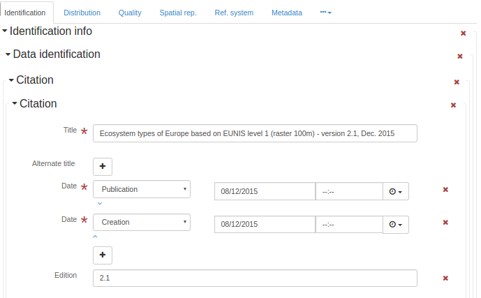
<gmd:citation xmlns:gmd="http://www.isotc211.org/2005/gmd" xmlns:gml="http://www.opengis.net/gml"
              xmlns:xlink="http://www.w3.org/1999/xlink">
   <gmd:CI_Citation>
      <gmd:title>
         <gco:CharacterString>Ecosystem types of Europe based on EUNIS level 1 (raster 100m) -
              version 2.1, Dec. 2015
            </gco:CharacterString>
      </gmd:title>
      <gmd:date>
         <gmd:CI_Date>
            <gmd:date>
               <gco:Date>2015-12-08</gco:Date>
            </gmd:date>
            <gmd:dateType>
               <gmd:CI_DateTypeCode codeList="http://standards.iso.org/ittf/PubliclyAvailableStandards/ISO_19139_Schemas/resources/codelist/ML_gmxCodelists.xml#CI_DateTypeCode"
                                    codeListValue="publication"/>
            </gmd:dateType>
         </gmd:CI_Date>
      </gmd:date>
      <gmd:date>
         <gmd:CI_Date>
            <gmd:date>
               <gco:Date>2015-12-08</gco:Date>
            </gmd:date>
            <gmd:dateType>
               <gmd:CI_DateTypeCode codeList="http://standards.iso.org/ittf/PubliclyAvailableStandards/ISO_19139_Schemas/resources/codelist/ML_gmxCodelists.xml#CI_DateTypeCode"
                                    codeListValue="creation"/>
            </gmd:dateType>
         </gmd:CI_Date>
      </gmd:date>
      <gmd:edition>
         <gco:CharacterString>2.1</gco:CharacterString>
      </gmd:edition>
      <gmd:identifier>
         <gmd:RS_Identifier>
            <gmd:code>
               <gco:CharacterString>eea_r_3035_100_m_ecosystem-types-l1_2006_rev2-1
                </gco:CharacterString>
            </gmd:code>
         </gmd:RS_Identifier>
      </gmd:identifier>
   </gmd:CI_Citation>
</gmd:citation>
引用
- 名字
gmd:引文
- 语境
gmd:MD_叙词表
- 描述
<gmd:citation xmlns:gmd="http://www.isotc211.org/2005/gmd" xmlns:gml="http://www.opengis.net/gml"
              xmlns:xlink="http://www.w3.org/1999/xlink">
   <gmd:CI_Citation>
      <gmd:title>
         <gco:CharacterString>Ecosystem types of Europe based on EUNIS level 1 (raster 100m) -
              version 2.1, Dec. 2015
            </gco:CharacterString>
      </gmd:title>
      <gmd:date>
         <gmd:CI_Date>
            <gmd:date>
               <gco:Date>2015-12-08</gco:Date>
            </gmd:date>
            <gmd:dateType>
               <gmd:CI_DateTypeCode codeList="http://standards.iso.org/ittf/PubliclyAvailableStandards/ISO_19139_Schemas/resources/codelist/ML_gmxCodelists.xml#CI_DateTypeCode"
                                    codeListValue="publication"/>
            </gmd:dateType>
         </gmd:CI_Date>
      </gmd:date>
      <gmd:date>
         <gmd:CI_Date>
            <gmd:date>
               <gco:Date>2015-12-08</gco:Date>
            </gmd:date>
            <gmd:dateType>
               <gmd:CI_DateTypeCode codeList="http://standards.iso.org/ittf/PubliclyAvailableStandards/ISO_19139_Schemas/resources/codelist/ML_gmxCodelists.xml#CI_DateTypeCode"
                                    codeListValue="creation"/>
            </gmd:dateType>
         </gmd:CI_Date>
      </gmd:date>
      <gmd:edition>
         <gco:CharacterString>2.1</gco:CharacterString>
      </gmd:edition>
      <gmd:identifier>
         <gmd:RS_Identifier>
            <gmd:code>
               <gco:CharacterString>eea_r_3035_100_m_ecosystem-types-l1_2006_rev2-1
                </gco:CharacterString>
            </gmd:code>
         </gmd:RS_Identifier>
      </gmd:identifier>
   </gmd:CI_Citation>
</gmd:citation>
引用
- 名字
gmd:引文
- 描述
<gmd:citation xmlns:gmd="http://www.isotc211.org/2005/gmd" xmlns:gml="http://www.opengis.net/gml"
              xmlns:xlink="http://www.w3.org/1999/xlink">
   <gmd:CI_Citation>
      <gmd:title>
         <gco:CharacterString>Ecosystem types of Europe based on EUNIS level 1 (raster 100m) -
              version 2.1, Dec. 2015
            </gco:CharacterString>
      </gmd:title>
      <gmd:date>
         <gmd:CI_Date>
            <gmd:date>
               <gco:Date>2015-12-08</gco:Date>
            </gmd:date>
            <gmd:dateType>
               <gmd:CI_DateTypeCode codeList="http://standards.iso.org/ittf/PubliclyAvailableStandards/ISO_19139_Schemas/resources/codelist/ML_gmxCodelists.xml#CI_DateTypeCode"
                                    codeListValue="publication"/>
            </gmd:dateType>
         </gmd:CI_Date>
      </gmd:date>
      <gmd:date>
         <gmd:CI_Date>
            <gmd:date>
               <gco:Date>2015-12-08</gco:Date>
            </gmd:date>
            <gmd:dateType>
               <gmd:CI_DateTypeCode codeList="http://standards.iso.org/ittf/PubliclyAvailableStandards/ISO_19139_Schemas/resources/codelist/ML_gmxCodelists.xml#CI_DateTypeCode"
                                    codeListValue="creation"/>
            </gmd:dateType>
         </gmd:CI_Date>
      </gmd:date>
      <gmd:edition>
         <gco:CharacterString>2.1</gco:CharacterString>
      </gmd:edition>
      <gmd:identifier>
         <gmd:RS_Identifier>
            <gmd:code>
               <gco:CharacterString>eea_r_3035_100_m_ecosystem-types-l1_2006_rev2-1
                </gco:CharacterString>
            </gmd:code>
         </gmd:RS_Identifier>
      </gmd:identifier>
   </gmd:CI_Citation>
</gmd:citation>
被引用责任方
- 名字
gmd:城市责任方
- 描述
西蒂
- 名字
gmd:城市
- 描述
分类
- 名字
gmd:分类
- 描述
- 条件
强制性的
分类系统
- 名字
gmd:分类系统
- 描述
云覆盖率
- 名字
gmd:云量覆盖率
- 描述
唯一资源标识符
- 名字
gmd:代码
- 语境
gmd:RS_标识符
- 描述
- 条件
强制性的
代码
- 名字
gmd:代码
- 语境
gmd:MD_标识符
- 描述
- 条件
强制性的
代码
- 名字
gmd:代码
- 语境
gmd:MD_码值
- 描述
码空间
- 名字
gmd:码空间
- 描述
推荐值
代码 |
标签 |
|---|---|
EPSG |
EPSG |
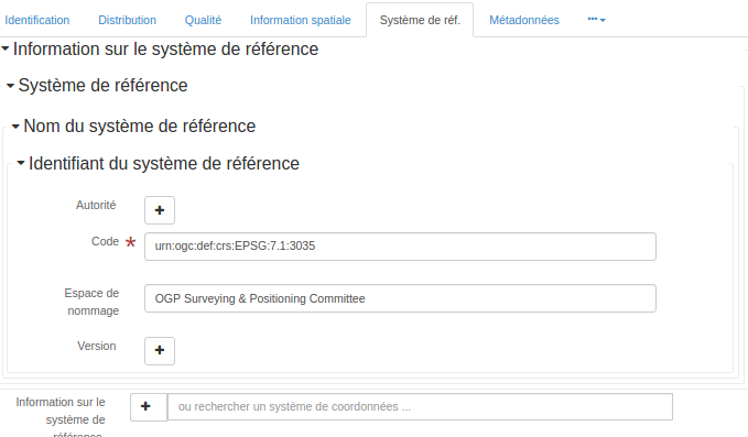
<gmd:codeSpace xmlns:gmd="http://www.isotc211.org/2005/gmd" xmlns:gml="http://www.opengis.net/gml"
xmlns:xlink="http://www.w3.org/1999/xlink">
<gco:CharacterString>OGP Surveying & Positioning Committee</gco:CharacterString>
</gmd:codeSpace>
集体所有权
- 名字
gmd:集合标题
- 描述
合规准则
- 名字
gmd:符合代码
- 描述
ComposedOf
- 名字
gmd:由
- 描述
压缩生成量
- 名字
gmd:压缩生成量
- 描述
条件
- 名字
gmd:条件
- 描述
约束语言
- 名字
gmd:约束语言
- 描述
- 条件
强制性的
联系
- 名字
gmd:联系人
- 语境
gmd:MD_元数据
- 描述
- 条件
强制性的
<gmd:contact xmlns:gmd="http://www.isotc211.org/2005/gmd" xmlns:gml="http://www.opengis.net/gml"
             xmlns:xlink="http://www.w3.org/1999/xlink">
   <gmd:CI_ResponsibleParty>
      <gmd:organisationName>
         <gco:CharacterString>European Environment Agency</gco:CharacterString>
      </gmd:organisationName>
      <gmd:contactInfo>
         <gmd:CI_Contact>
            <gmd:address>
               <gmd:CI_Address>
                  <gmd:deliveryPoint>
                     <gco:CharacterString>Kongens Nytorv 6</gco:CharacterString>
                  </gmd:deliveryPoint>
                  <gmd:city>
                     <gco:CharacterString>Copenhagen</gco:CharacterString>
                  </gmd:city>
                  <gmd:administrativeArea>
                     <gco:CharacterString>K</gco:CharacterString>
                  </gmd:administrativeArea>
                  <gmd:postalCode>
                     <gco:CharacterString>1050</gco:CharacterString>
                  </gmd:postalCode>
                  <gmd:country>
                     <gco:CharacterString>Denmark</gco:CharacterString>
                  </gmd:country>
                  <gmd:electronicMailAddress>
                     <gco:CharacterString>eea.enquiries@eea.europa.eu</gco:CharacterString>
                  </gmd:electronicMailAddress>
               </gmd:CI_Address>
            </gmd:address>
         </gmd:CI_Contact>
      </gmd:contactInfo>
      <gmd:role>
         <gmd:CI_RoleCode codeList="http://standards.iso.org/ittf/PubliclyAvailableStandards/ISO_19139_Schemas/resources/codelist/ML_gmxCodelists.xml#CI_RoleCode"
                          codeListValue="pointOfContact"/>
      </gmd:role>
   </gmd:CI_ResponsibleParty>
</gmd:contact>
联系
- 名字
gmd:联系人
- 语境
gmd:MD U维护信息
- 描述
<gmd:contact xmlns:gmd="http://www.isotc211.org/2005/gmd" xmlns:gml="http://www.opengis.net/gml"
             xmlns:xlink="http://www.w3.org/1999/xlink">
   <gmd:CI_ResponsibleParty>
      <gmd:organisationName>
         <gco:CharacterString>European Environment Agency</gco:CharacterString>
      </gmd:organisationName>
      <gmd:contactInfo>
         <gmd:CI_Contact>
            <gmd:address>
               <gmd:CI_Address>
                  <gmd:deliveryPoint>
                     <gco:CharacterString>Kongens Nytorv 6</gco:CharacterString>
                  </gmd:deliveryPoint>
                  <gmd:city>
                     <gco:CharacterString>Copenhagen</gco:CharacterString>
                  </gmd:city>
                  <gmd:administrativeArea>
                     <gco:CharacterString>K</gco:CharacterString>
                  </gmd:administrativeArea>
                  <gmd:postalCode>
                     <gco:CharacterString>1050</gco:CharacterString>
                  </gmd:postalCode>
                  <gmd:country>
                     <gco:CharacterString>Denmark</gco:CharacterString>
                  </gmd:country>
                  <gmd:electronicMailAddress>
                     <gco:CharacterString>eea.enquiries@eea.europa.eu</gco:CharacterString>
                  </gmd:electronicMailAddress>
               </gmd:CI_Address>
            </gmd:address>
         </gmd:CI_Contact>
      </gmd:contactInfo>
      <gmd:role>
         <gmd:CI_RoleCode codeList="http://standards.iso.org/ittf/PubliclyAvailableStandards/ISO_19139_Schemas/resources/codelist/ML_gmxCodelists.xml#CI_RoleCode"
                          codeListValue="pointOfContact"/>
      </gmd:role>
   </gmd:CI_ResponsibleParty>
</gmd:contact>
联系方式
- 名字
gmd:联系人信息
- 描述
联系方式
- 名字
gmd:联系说明
- 描述
内容信息
- 名字
gmd:内容信息
- 描述
<gmd:contentInfo xmlns:gmd="http://www.isotc211.org/2005/gmd" xmlns:gml="http://www.opengis.net/gml"
xmlns:xlink="http://www.w3.org/1999/xlink">
<gmd:MD_FeatureCatalogueDescription>
<gmd:includedWithDataset>
<gco:Boolean>false</gco:Boolean>
</gmd:includedWithDataset>
<gmd:featureCatalogueCitation uuidref="e38815ec-a386-45e5-9d1c-b13e0f6ca9e0"
xlink:href="http://sdi.eea.europa.eu/internal-catalogue/srv/eng/csw?service=CSW&request=GetRecordById&version=2.0.2&outputSchema=http://www.isotc211.org/2005/gmd&elementSetName=full&id=e38815ec-a386-45e5-9d1c-b13e0f6ca9e0"/>
</gmd:MD_FeatureCatalogueDescription>
</gmd:contentInfo>
内容类型
- 名字
gmd:内容类型
- 描述
- 条件
强制性的
控制点可用性
- 名字
gmd:控制点可用性
- 描述
- 条件
强制性的
角点
- 名字
gmd:拐点
- 描述
- 条件
强制性的
国家
- 名字
gmd:国家
- 描述
国家
- 名字
gmd:国家
- 语境
gmd:MD_立法
- 描述
国家
- 名字
gmd:国家
- 语境
PT_Group
- 描述
信用卡
- 名字
gmd:信用
- 描述
数据质量信息
- 名字
gmd:数据质量信息
- 描述
<gmd:dataQualityInfo xmlns:gmd="http://www.isotc211.org/2005/gmd" xmlns:gml="http://www.opengis.net/gml"
xmlns:xlink="http://www.w3.org/1999/xlink">
<gmd:DQ_DataQuality>
<gmd:scope>
<gmd:DQ_Scope>
<gmd:level>
<gmd:MD_ScopeCode codeListValue="dataset"
codeList="http://standards.iso.org/ittf/PubliclyAvailableStandards/ISO_19139_Schemas/resources/codelist/ML_gmxCodelists.xml#MD_ScopeCode"/>
</gmd:level>
</gmd:DQ_Scope>
</gmd:scope>
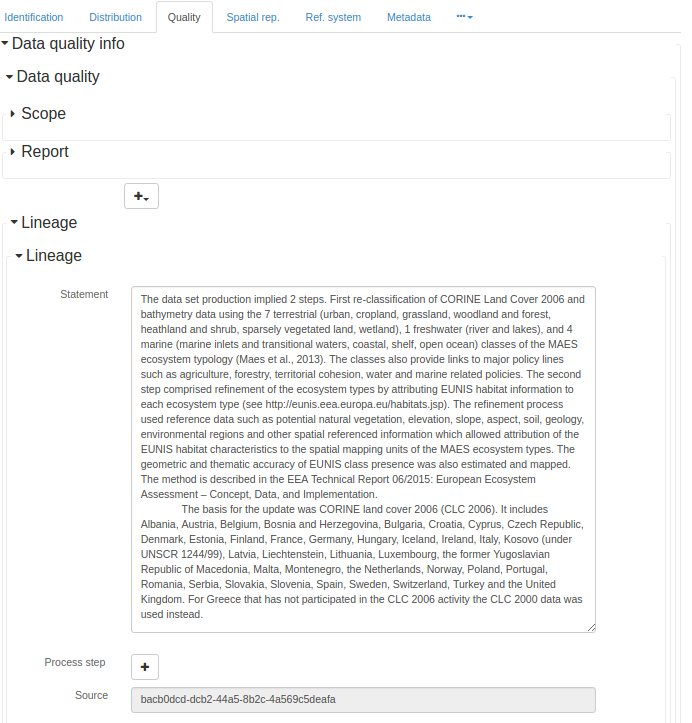
<gmd:lineage>
<gmd:LI_Lineage>
<gmd:statement>
<gco:CharacterString>The data set production implied 2 steps. First re-classification of
CORINE Land Cover 2006 and bathymetry data using the 7 terrestrial (urban, cropland,
grassland, woodland and forest, heathland and shrub, sparsely vegetated land,
wetland), 1 freshwater (river and lakes), and 4 marine (marine inlets and transitional
waters, coastal, shelf, open ocean) classes of the MAES ecosystem typology (Maes et
al., 2013). The classes also provide links to major policy lines such as agriculture,
forestry, territorial cohesion, water and marine related policies. The second step
comprised refinement of the ecosystem types by attributing EUNIS habitat information
to each ecosystem type (see http://eunis.eea.europa.eu/habitats.jsp). The refinement
process used reference data such as potential natural vegetation, elevation, slope,
aspect, soil, geology, environmental regions and other spatial referenced information
which allowed attribution of the EUNIS habitat characteristics to the spatial mapping
units of the MAES ecosystem types. The geometric and thematic accuracy of EUNIS class
presence was also estimated and mapped. The method is described in the EEA Technical
Report 06/2015: European Ecosystem Assessment – Concept, Data, and Implementation.
The basis for the update was CORINE land cover 2006 (CLC 2006). It includes Albania,
Austria, Belgium, Bosnia and Herzegovina, Bulgaria, Croatia, Cyprus, Czech Republic,
Denmark, Estonia, Finland, France, Germany, Hungary, Iceland, Ireland, Italy, Kosovo
(under UNSCR 1244/99), Latvia, Liechtenstein, Lithuania, Luxembourg, the former
Yugoslavian Republic of Macedonia, Malta, Montenegro, the Netherlands, Norway, Poland,
Portugal, Romania, Serbia, Slovakia, Slovenia, Spain, Sweden, Switzerland, Turkey and
the United Kingdom. For Greece that has not participated in the CLC 2006 activity the
CLC 2000 data was used instead.
</gco:CharacterString>
</gmd:statement>
<gmd:source uuidref="bacb0dcd-dcb2-44a5-8b2c-4a569c5deafa"/>
</gmd:LI_Lineage>
</gmd:lineage>
</gmd:DQ_DataQuality>
</gmd:dataQualityInfo>
数据集
- 名字
gmd:数据集
- 描述
数据集URI
- 名字
gmd:dataSetURI
- 描述
数据类型
- 名字
gmd:数据类型
- 描述
- 条件
强制性的
日期
- 名字
gmd:日期
- 描述
- 条件
强制性的
上次更新日期
- 名字
gmd:日期
- 语境
gmd:MD U修订版
- 描述
下次更新日期
- 名字
gmd:日期
- 语境
gmd:MD U维护信息
- 描述
日期
- 名字
gmd:日期
- 语境
gmd:引文
- 描述
- 条件
强制性的
日期
- 名字
gmd:日期
- 语境
gmd:CI_日期
- 描述
- 条件
强制性的
下次更新日期
- 名字
gmd:dateOfNextUpdate
- 描述
日期戳
- 名字
gmd:日期戳
- 描述
- 条件
强制性的
<gmd:dateStamp xmlns:gmd="http://www.isotc211.org/2005/gmd" xmlns:gml="http://www.opengis.net/gml"
               xmlns:xlink="http://www.w3.org/1999/xlink">
   <gco:DateTime>2016-01-15T16:57:35</gco:DateTime>
</gmd:dateStamp>
日期/时间
- 名字
gmd:日期时间
- 描述
日期/时间
- 名字
gmd:日期时间
- 语境
LI_ProcessStep
- 描述
日期/时间
- 名字
gmd:日期时间
- 语境
gmd:DQ_元素
- 描述
日期类型
- 名字
gmd:日期类型
- 描述
- 条件
强制性的
定义
- 名字
gmd:定义
- 描述
- 条件
强制性的
交货地点
- 名字
gmd:交货点
- 描述
分母
- 名字
gmd:分母
- 描述
- 条件
添加分母或距离
推荐值
代码 |
标签 |
|---|---|
5000 |
1: 5000英镑 |
10000 |
1: 10000 |
25000 |
1: 25000 |
50000 |
1: 5万 |
100000 |
1: 10万 |
200000 |
1: 20万 |
300000 |
1: 30万 |
500000 |
1: 50万 |
1000000 |
1: 1000万 |
密度
- 名字
gmd:密度
- 描述
密度单位
- 名字
gmd:密度单位
- 描述
- 条件
有条件的
描写
- 名字
gmd:描述
- 描述
描述
- 名字
gmd:说明
- 描述
描述
- 名字
gmd:说明
- 语境
gmd:MD_抽象类
- 描述
描述
- 名字
gmd:说明
- 语境
LI_ProcessStep
- 描述
- 条件
强制性的
描述
- 名字
gmd:说明
- 语境
LI_Source
- 描述
描述
- 名字
gmd:说明
- 语境
gmd:EX_范围
- 描述
描述
- 名字
gmd:说明
- 语境
gmd:仅限CI资源
- 描述
推荐值
代码 |
标签 |
|---|---|
ETRS89/LAEA欧洲 |
|
比利时1972/比利时兰伯特72 |
|
ETRS89-XYZ:ETRS89中的三维笛卡尔 |
|
ETRS89-GRS80h:GRS80上ETRS89中的三维大地测量 |
|
ETRS89-GRS802D:GRS80上ETRS89中的大地测量 |
|
ETRS89-LAEA2D:GRS80上ETRS89中的LAEA投影 |
|
ETRS89-LCC2D:GRS80上ETRS89中的LCC投影 |
|
ETRS89-TM26N2D:ETRS89中GRS80 26N区(30°W至24°W)上的TM投影 |
|
ETRS89-TM27N2D:27N区(24°W至18°W)GRS80上ETRS89中的TM投影 |
|
ETRS89-TM28N:28N区(18°W至12°W)上ETRS89中的二维TM投影 |
|
ETRS89-TM29N:ETRS89中GRS80 29N区(12°W至6°W)上的二维TM投影 |
|
ETRS89-TM30N:ETRS89中GRS80区域30N(6°W至0°)上的二维TM投影 |
|
ETRS89-TM31N:ETRS89中GRS80 31N区(0°至6°E)上的二维TM投影 |
|
ETRS89-TM32N:ETRS89中GRS80 32N区(6°E至12°E)上的二维TM投影 |
|
ETRS89-TM33N:ETRS89中GRS80 33N区(12°E至18°E)上的二维TM投影 |
|
ETRS89-TM34N:ETRS89中GRS80 34N区(18°E至24°E)上的二维TM投影 |
|
ETRS89-TM35N:ETRS89中GRS80 35N区(24°E至30°E)上的二维TM投影 |
|
ETRS89-TM36N:ETRS89中GRS80 36N区(30°E至36°E)上的二维TM投影 |
|
ETRS89-TM37N:ETRS89中GRS80 37N区(36°E至42°E)上的二维TM投影 |
|
ETRS89-TM38N:ETRS89中GRS80 38N区(42°E至48°E)上的二维TM投影 |
|
ETRS89-TM39N:ETRS89中GRS80 39N区(48°E至54°E)上的二维TM投影 |
|
EVRS:EVRS中的高度 |
|
ETRS89-GRS80-EVRS:3D复合:GRS80上ETRS89中的二维大地测量和EVRS高度 |
|
RGF93/兰伯特-93 |
|
WGS 84/UTM 20N区 |
|
RGFG95/UTM 22N区 |
|
RGR92/UTM区域40S |
|
RGSPM06/UTM 21N区 |
|
RGM04/UTM 38S区 |
描述
- 名字
gmd:说明
- 语境
gmd:MD_代码域
- 描述
价值描述
- 名字
gmd:说明
- 语境
gmd:MD_码值
- 描述
描述
- 名字
gmd:说明
- 语境
gmd:MD_属性
- 描述
描述
- 名字
gmd:说明
- 语境
gmd:MD_角色
- 描述
描述性关键字
- 名字
gmd:描述关键字
- 描述
描述符
- 名字
gmd:描述符
- 描述
尺寸
- 名字
gmd:尺寸
- 描述
维度名称
- 名字
gmd:维度名称
- 描述
- 条件
强制性的
尺寸大小
- 名字
gmd:尺寸
- 描述
- 条件
强制性的
距离
- 名字
gmd:距离
- 描述
- 条件
如果未记录等效比例尺,则提供距离
推荐值
代码 |
标签 |
|---|---|
0.10 |
10厘米 |
0.25 |
25厘米 |
0.50 |
50厘米 |
1 |
1米 |
30 |
30米 |
100 |
100米 |
<gmd:distance xmlns:gmd="http://www.isotc211.org/2005/gmd" xmlns:gml="http://www.opengis.net/gml"
              xmlns:xlink="http://www.w3.org/1999/xlink">
   <gco:Distance uom="m">100</gco:Distance>
</gmd:distance>
分发格式
- 名字
gmd:分布式格式
- 描述
- 条件
强制性的
<gmd:distributionFormat xmlns:gmd="http://www.isotc211.org/2005/gmd" xmlns:gml="http://www.opengis.net/gml"
                        xmlns:xlink="http://www.w3.org/1999/xlink">
   <gmd:MD_Format>
      <gmd:name>
         <gco:CharacterString>GTiff</gco:CharacterString>
      </gmd:name>
      <gmd:version gco:nilReason="missing">
         <gco:CharacterString/>
      </gmd:version>
   </gmd:MD_Format>
</gmd:distributionFormat>
分发信息
- 名字
gmd:分布信息
- 描述
<gmd:distributionInfo xmlns:gmd="http://www.isotc211.org/2005/gmd" xmlns:gml="http://www.opengis.net/gml"
                      xmlns:xlink="http://www.w3.org/1999/xlink">
   <gmd:MD_Distribution>
      <gmd:distributionFormat>
         <gmd:MD_Format>
            <gmd:name>
               <gco:CharacterString>GTiff</gco:CharacterString>
            </gmd:name>
            <gmd:version gco:nilReason="missing">
               <gco:CharacterString/>
            </gmd:version>
         </gmd:MD_Format>
      </gmd:distributionFormat>
      <gmd:transferOptions>
         <gmd:MD_DigitalTransferOptions>
            <gmd:onLine>
               <gmd:CI_OnlineResource>
                  <gmd:linkage>
                     <gmd:URL>
                  http://www.eea.europa.eu/data-and-maps/data/ds_resolveuid/d851e1b7f678468b8f0b1b98930ba3e1
                </gmd:URL>
                  </gmd:linkage>
                  <gmd:protocol>
                     <gco:CharacterString>WWW:LINK-1.0-http--link</gco:CharacterString>
                  </gmd:protocol>
                  <gmd:function>
                     <gmd:CI_OnLineFunctionCode codeList="http://standards.iso.org/ittf/PubliclyAvailableStandards/ISO_19139_Schemas/resources/codelist/ML_gmxCodelists.xml#CI_OnLineFunctionCode"
                                                codeListValue="download"/>
                  </gmd:function>
               </gmd:CI_OnlineResource>
            </gmd:onLine>
         </gmd:MD_DigitalTransferOptions>
      </gmd:transferOptions>
   </gmd:MD_Distribution>
</gmd:distributionInfo>
分销/订单流程
- 名字
gmd:分布顺序过程
- 描述
经销商
- 名字
gmd:经销商
- 描述
经销商联系人
- 名字
gmd:经销商联系人
- 描述
- 条件
强制性的
分发服务器格式
- 名字
gmd:分发格式
- 描述
- 条件
有条件的
分销商转移选项
- 名字
gmd:分销转换
- 描述
域代码
- 名字
gmd:域代码
- 描述
有效域
- 名字
gmd:有效域
- 描述
域值
- 名字
gmd:domainValue
- 描述
绝对外部位置精度
- 名字
gmd:DQ_绝对外部位置精度
- 描述
时间测量精度
- 名字
gmd:DQ_精确实时测量
- 描述
完整性委员会
- 名字
gmd:DQ_完成任务
- 描述
完全省略
- 名字
gmd:DQ_完成任务
- 描述
概念一致性
- 名字
gmd:DQ_概念一致性
- 描述
一致性结果
- 名字
gmd:DQ_一致性结果
- 描述
数据质量
- 名字
gmd:DQ U数据质量
- 描述
<gmd:DQ_DataQuality xmlns:gmd="http://www.isotc211.org/2005/gmd" xmlns:gml="http://www.opengis.net/gml"
                    xmlns:xlink="http://www.w3.org/1999/xlink">
   <gmd:scope>
      <gmd:DQ_Scope>
         <gmd:level>
            <gmd:MD_ScopeCode codeListValue="dataset"
                              codeList="http://standards.iso.org/ittf/PubliclyAvailableStandards/ISO_19139_Schemas/resources/codelist/ML_gmxCodelists.xml#MD_ScopeCode"/>
         </gmd:level>
      </gmd:DQ_Scope>
   </gmd:scope>
   <gmd:lineage>
      <gmd:LI_Lineage>
         <gmd:statement>
            <gco:CharacterString>The data set production implied 2 steps. First re-classification of
              CORINE Land Cover 2006 and bathymetry data using the 7 terrestrial (urban, cropland,
              grassland, woodland and forest, heathland and shrub, sparsely vegetated land,
              wetland), 1 freshwater (river and lakes), and 4 marine (marine inlets and transitional
              waters, coastal, shelf, open ocean) classes of the MAES ecosystem typology (Maes et
              al., 2013). The classes also provide links to major policy lines such as agriculture,
              forestry, territorial cohesion, water and marine related policies. The second step
              comprised refinement of the ecosystem types by attributing EUNIS habitat information
              to each ecosystem type (see http://eunis.eea.europa.eu/habitats.jsp). The refinement
              process used reference data such as potential natural vegetation, elevation, slope,
              aspect, soil, geology, environmental regions and other spatial referenced information
              which allowed attribution of the EUNIS habitat characteristics to the spatial mapping
              units of the MAES ecosystem types. The geometric and thematic accuracy of EUNIS class
              presence was also estimated and mapped. The method is described in the EEA Technical
              Report 06/2015: European Ecosystem Assessment – Concept, Data, and Implementation.
              The basis for the update was CORINE land cover 2006 (CLC 2006). It includes Albania,
              Austria, Belgium, Bosnia and Herzegovina, Bulgaria, Croatia, Cyprus, Czech Republic,
              Denmark, Estonia, Finland, France, Germany, Hungary, Iceland, Ireland, Italy, Kosovo
              (under UNSCR 1244/99), Latvia, Liechtenstein, Lithuania, Luxembourg, the former
              Yugoslavian Republic of Macedonia, Malta, Montenegro, the Netherlands, Norway, Poland,
              Portugal, Romania, Serbia, Slovakia, Slovenia, Spain, Sweden, Switzerland, Turkey and
              the United Kingdom. For Greece that has not participated in the CLC 2006 activity the
              CLC 2000 data was used instead.
            </gco:CharacterString>
         </gmd:statement>
         <gmd:source uuidref="bacb0dcd-dcb2-44a5-8b2c-4a569c5deafa"/>
      </gmd:LI_Lineage>
   </gmd:lineage>
</gmd:DQ_DataQuality>
域一致性
- 名字
gmd:DQ_域一致性
- 描述
评估方法类型代码
- 名字
gmd:DQ U评估方法类型代码
- 描述
标准代码表评估方法类型代码(gmd:DQ U评估方法类型代码)
代码 |
标签 |
描述 |
|---|---|---|
直接内部 |
直接内部 |
基于对数据集中项目的检查来评估数据集质量的方法,其中所需的所有数据都在被评估的数据集中 |
直接外部 |
直接外部 |
基于对数据集中项目的检查评估数据集质量的方法,其中需要对数据集外部的引用数据进行评估 |
间接的 |
间接的 |
基于外部知识的数据集质量评价方法 |
格式一致性
- 名字
gmd:DQ_格式一致性
- 描述
网格数据位置精度
- 名字
gmd:DQ_网格数据位置精度
- 描述
非定量属性精度
- 名字
gmd:DQ_非定量属性精确度
- 描述
定量属性精度
- 名字
gmd:DQ_量化属性精确度
- 描述
定量结果
- 名字
gmd:DQ_量化结果
- 描述
相对内定位精度
- 名字
gmd:DQ_相对定位精度
- 描述
范围
- 名字
gmd:DQ U范围
- 描述
<gmd:DQ_Scope xmlns:gmd="http://www.isotc211.org/2005/gmd" xmlns:gml="http://www.opengis.net/gml"
              xmlns:xlink="http://www.w3.org/1999/xlink">
   <gmd:level>
      <gmd:MD_ScopeCode codeListValue="dataset"
                        codeList="http://standards.iso.org/ittf/PubliclyAvailableStandards/ISO_19139_Schemas/resources/codelist/ML_gmxCodelists.xml#MD_ScopeCode"/>
   </gmd:level>
</gmd:DQ_Scope>
时间一致性
- 名字
gmd:DQ_时间一致性
- 描述
时间有效性
- 名字
gmd:DQ_暂时性
- 描述
主题分类正确性
- 名字
gmd:DQ U主题分类正确性
- 描述
拓扑一致性
- 名字
gmd:DQ_拓扑一致性
- 描述
DS_Association
- 名字
gmd:DS U协会
- 描述
关联类型
- 名字
gmd:DS_关联类型码
- 描述
标准代码列表关联类型(gmd:DS_关联类型码)
代码 |
标签 |
描述 |
|---|---|---|
交叉引用 |
交叉引用 |
从一个数据集到另一个数据集的引用 |
大手笔 |
较大的作品引用 |
对主数据集的引用,此数据集是主数据集的一部分 |
部分水星数据库 |
无缝数据库的一部分 |
计算机中保存的同一结构化数据集的一部分 |
来源 |
来源 |
数据集内容来源的映射和图表信息 |
立体配合 |
立体伴侣 |
一组图像的一部分,当一起使用时,提供三维图像 |
DS_DataSet
- 名字
gmd:DS_数据集
- 描述
DS_Initiative
- 名字
gmd:DS-U倡议
- 描述
主动类型
- 名字
gmd:DS_初始化类型码
- 描述
标准代码表倡议类型(gmd:DS_初始化类型码)
代码 |
标签 |
描述 |
|---|---|---|
运动 |
运动 |
一系列有组织的计划行动 |
收集 |
Collection |
为特定目的组装的数据集的累积 |
运动 |
锻炼 |
一个函数或一组函数的特定性能 |
实验 |
实验 |
旨在发现某物是否有效或有效的过程 |
调查 |
调查 |
搜索或系统查询 |
使命 |
使命 |
数据采集系统的具体操作 |
传感器 |
传感器 |
探测或记录的装置或设备 |
操作 |
操作 |
作为一系列动作的一部分的动作 |
平台 |
站台 |
固定传感器的车辆或其他支撑底座 |
过程 |
过程 |
做某事的方法包括许多步骤 |
程序 |
程序 |
具体计划活动 |
项目 |
项目 |
有组织的事业、研究或发展 |
学习 |
书房 |
检查或调查 |
任务 |
任务 |
一件作品 |
试验 |
审判 |
发现或证明某事的测试过程 |
DS_OtherAggregate
- 名字
gmd:DS_其他聚合
- 描述
DS_Platform
- 名字
gmd:DS U平台
- 描述
DS_ProductionSeries
- 名字
gmd:DS_产品系列
- 描述
DS_Sensor
- 名字
gmd:DS U传感器
- 描述
DS_Series
- 名字
gmd:DS_系列
- 描述
DS_StereoMate
- 名字
gmd:DS_立体匹配
- 描述
向东
- 名字
gmd:东界经度
- 描述
- 条件
强制性的
<gmd:eastBoundLongitude xmlns:gmd="http://www.isotc211.org/2005/gmd" xmlns:gml="http://www.opengis.net/gml"
                        xmlns:xlink="http://www.w3.org/1999/xlink">
   <gco:Decimal>38.1471</gco:Decimal>
</gmd:eastBoundLongitude>
版本
- 名字
gmd:版本
- 描述
<gmd:edition xmlns:gmd="http://www.isotc211.org/2005/gmd" xmlns:gml="http://www.opengis.net/gml"
             xmlns:xlink="http://www.w3.org/1999/xlink">
   <gco:CharacterString>2.1</gco:CharacterString>
</gmd:edition>
版本日期
- 名字
gmd:编辑日期
- 描述
电子邮件地址
- 名字
gmd:电子邮箱地址
- 描述
环境描述
- 名字
gmd:环境描述
- 描述
当量比例尺
- 名字
gmd:同等比例
- 描述
误差统计
- 名字
gmd:错误统计
- 描述
评价方法描述
- 名字
gmd:评估方法描述
- 描述
评价方法
- 名字
gmd:评估方法类型
- 描述
评价程序
- 名字
gmd:评估程序
- 描述
边界多边形
- 名字
gmd:外边界多边形
- 描述
范围
- 名字
gmd:EX_范围
- 描述
地理边界框
- 名字
gmd:地理边界框
- 描述
<gmd:EX_GeographicBoundingBox xmlns:gmd="http://www.isotc211.org/2005/gmd" xmlns:gml="http://www.opengis.net/gml"
                              xmlns:xlink="http://www.w3.org/1999/xlink">
   <gmd:westBoundLongitude>
      <gco:Decimal>-33.90432</gco:Decimal>
   </gmd:westBoundLongitude>
   <gmd:eastBoundLongitude>
      <gco:Decimal>38.1471</gco:Decimal>
   </gmd:eastBoundLongitude>
   <gmd:southBoundLatitude>
      <gco:Decimal>26.988714</gco:Decimal>
   </gmd:southBoundLatitude>
   <gmd:northBoundLatitude>
      <gco:Decimal>60.57849</gco:Decimal>
   </gmd:northBoundLatitude>
</gmd:EX_GeographicBoundingBox>
地理描述
- 名字
gmd:地理描述
- 描述
时空范围
- 名字
gmd:前空间时态
- 描述
时间范围
- 名字
gmd:前临时工
- 描述
<gmd:EX_TemporalExtent xmlns:gmd="http://www.isotc211.org/2005/gmd" xmlns:gml="http://www.opengis.net/gml"
                       xmlns:xlink="http://www.w3.org/1999/xlink">
   <gmd:extent>
      <gml:TimePeriod gml:id="d28e322a1049886">
         <gml:beginPosition>2006-01-01</gml:beginPosition>
         <gml:endPosition>2006-12-31</gml:endPosition>
      </gml:TimePeriod>
   </gmd:extent>
</gmd:EX_TemporalExtent>
垂直范围
- 名字
gmd:EX_垂直延伸
- 描述
解释
- 名字
gmd:解释
- 描述
- 条件
强制性的
扩展元素信息
- 名字
gmd:扩展元素信息
- 描述
扩展联机资源
- 名字
gmd:扩展联机资源
- 描述
范围
- 名字
gmd:范围
- 语境
gmd:MD U数据标识
- 描述
范围
- 名字
gmd:范围
- 语境
gmd:DQ U范围
- 描述
范围
- 名字
gmd:范围
- 语境
gmd:前临时工
- 描述
区段类型代码
- 名字
gmd:扩展类型码
- 描述
传真
- 名字
gmd:传真
- 描述
特征属性
- 名字
gmd:特性属性
- 描述
专题目录引文
- 名字
gmd:特性目录指定
- 描述
- 条件
强制性的
<gmd:featureCatalogueCitation xmlns:gmd="http://www.isotc211.org/2005/gmd" xmlns:gml="http://www.opengis.net/gml"
uuidref="e38815ec-a386-45e5-9d1c-b13e0f6ca9e0"
xlink:href="http://sdi.eea.europa.eu/internal-catalogue/srv/eng/csw?service=CSW&request=GetRecordById&version=2.0.2&outputSchema=http://www.isotc211.org/2005/gmd&elementSetName=full&id=e38815ec-a386-45e5-9d1c-b13e0f6ca9e0"/>
要素实例
- 名字
gmd:功能实例
- 描述
特征
- 名字
gmd:特点
- 描述
特征类型
- 名字
gmd:功能类型
- 描述
功能类型
- 名字
gmd:功能类型
- 描述
费用
- 名字
gmd:费用
- 描述
文件解压技术
- 名字
gmd:文件解压缩技术
- 描述
文件说明
- 名字
gmd:文件描述
- 描述
文件标识符
- 名字
gmd:文件标识符
- 描述
<gmd:fileIdentifier xmlns:gmd="http://www.isotc211.org/2005/gmd" xmlns:gml="http://www.opengis.net/gml"
                    xmlns:xlink="http://www.w3.org/1999/xlink">
   <gco:CharacterString>e8a366b7-0029-44d7-ae33-7578253179c0</gco:CharacterString>
</gmd:fileIdentifier>
文件名
- 名字
gmd:文件名
- 描述
- 条件
强制性的
<gmd:fileName xmlns:gmd="http://www.isotc211.org/2005/gmd" xmlns:gml="http://www.opengis.net/gml"
              xmlns:xlink="http://www.w3.org/1999/xlink">
   <gco:CharacterString>
              http://sdi.eea.europa.eu/public/catalogue-graphic-overview/e8a366b7-0029-44d7-ae33-7578253179c0.png
            </gco:CharacterString>
</gmd:fileName>
文件类型
- 名字
gmd:文件类型
- 描述
胶片失真信息可用性
- 名字
gmd:电影扭曲信息可用性
- 描述
格式分发服务器
- 名字
gmd:格式分发服务器
- 描述
功能
- 名字
gmd:功能
- 描述
地理要素
- 名字
gmd:地理位置
- 描述
<gmd:geographicElement xmlns:gmd="http://www.isotc211.org/2005/gmd" xmlns:gml="http://www.opengis.net/gml"
                       xmlns:xlink="http://www.w3.org/1999/xlink">
   <gmd:EX_GeographicBoundingBox>
      <gmd:westBoundLongitude>
         <gco:Decimal>-33.90432</gco:Decimal>
      </gmd:westBoundLongitude>
      <gmd:eastBoundLongitude>
         <gco:Decimal>38.1471</gco:Decimal>
      </gmd:eastBoundLongitude>
      <gmd:southBoundLatitude>
         <gco:Decimal>26.988714</gco:Decimal>
      </gmd:southBoundLatitude>
      <gmd:northBoundLatitude>
         <gco:Decimal>60.57849</gco:Decimal>
      </gmd:northBoundLatitude>
   </gmd:EX_GeographicBoundingBox>
</gmd:geographicElement>
地理标识
- 名字
gmd:地理标识符
- 描述
- 条件
强制性的
几何对象计数
- 名字
gmd:几何对象计数
- 描述
几何对象
- 名字
几何体
- 描述
几何对象类型
- 名字
gmd:几何对象类型
- 描述
- 条件
强制性的
GeoreferencedParameters
- 名字
gmd:地理参考参数
- 描述
图形概述
- 名字
gmd:图形概述
- 描述
<gmd:graphicOverview xmlns:gmd="http://www.isotc211.org/2005/gmd" xmlns:gml="http://www.opengis.net/gml"
                     xmlns:xlink="http://www.w3.org/1999/xlink">
   <gmd:MD_BrowseGraphic>
      <gmd:fileName>
         <gco:CharacterString>
              http://sdi.eea.europa.eu/public/catalogue-graphic-overview/e8a366b7-0029-44d7-ae33-7578253179c0.png
            </gco:CharacterString>
      </gmd:fileName>
   </gmd:MD_BrowseGraphic>
</gmd:graphicOverview>
图形文件
- 名字
gmd:图形文件
- 描述
操作说明
- 名字
gmd:处理说明
- 描述
有
- 名字
总经理:有
- 描述
层次结构级别
- 名字
gmd:等级
- 描述
<gmd:hierarchyLevel xmlns:gmd="http://www.isotc211.org/2005/gmd" xmlns:gml="http://www.opengis.net/gml"
                    xmlns:xlink="http://www.w3.org/1999/xlink">
   <gmd:MD_ScopeCode codeList="http://standards.iso.org/ittf/PubliclyAvailableStandards/ISO_19139_Schemas/resources/codelist/ML_gmxCodelists.xml#MD_ScopeCode"
                     codeListValue="dataset"/>
</gmd:hierarchyLevel>
层次结构级别名称
- 名字
gmd:层次名称
- 描述
服务时间
- 名字
gmd:服务时间
- 描述
身份信息
- 名字
gmd:标识信息
- 描述
- 条件
强制性的
<gmd:identificationInfo xmlns:gmd="http://www.isotc211.org/2005/gmd" xmlns:gml="http://www.opengis.net/gml"
xmlns:xlink="http://www.w3.org/1999/xlink">
<gmd:MD_DataIdentification>
<gmd:citation>
<gmd:CI_Citation>
<gmd:title>
<gco:CharacterString>Ecosystem types of Europe based on EUNIS level 1 (raster 100m) -
version 2.1, Dec. 2015
</gco:CharacterString>
</gmd:title>
<gmd:date>
<gmd:CI_Date>
<gmd:date>
<gco:Date>2015-12-08</gco:Date>
</gmd:date>
<gmd:dateType>
<gmd:CI_DateTypeCode codeList="http://standards.iso.org/ittf/PubliclyAvailableStandards/ISO_19139_Schemas/resources/codelist/ML_gmxCodelists.xml#CI_DateTypeCode"
codeListValue="publication"/>
</gmd:dateType>
</gmd:CI_Date>
</gmd:date>
<gmd:date>
<gmd:CI_Date>
<gmd:date>
<gco:Date>2015-12-08</gco:Date>
</gmd:date>
<gmd:dateType>
<gmd:CI_DateTypeCode codeList="http://standards.iso.org/ittf/PubliclyAvailableStandards/ISO_19139_Schemas/resources/codelist/ML_gmxCodelists.xml#CI_DateTypeCode"
codeListValue="creation"/>
</gmd:dateType>
</gmd:CI_Date>
</gmd:date>
<gmd:edition>
<gco:CharacterString>2.1</gco:CharacterString>
</gmd:edition>
<gmd:identifier>
<gmd:RS_Identifier>
<gmd:code>
<gco:CharacterString>eea_r_3035_100_m_ecosystem-types-l1_2006_rev2-1
</gco:CharacterString>
</gmd:code>
</gmd:RS_Identifier>
</gmd:identifier>
</gmd:CI_Citation>
</gmd:citation>
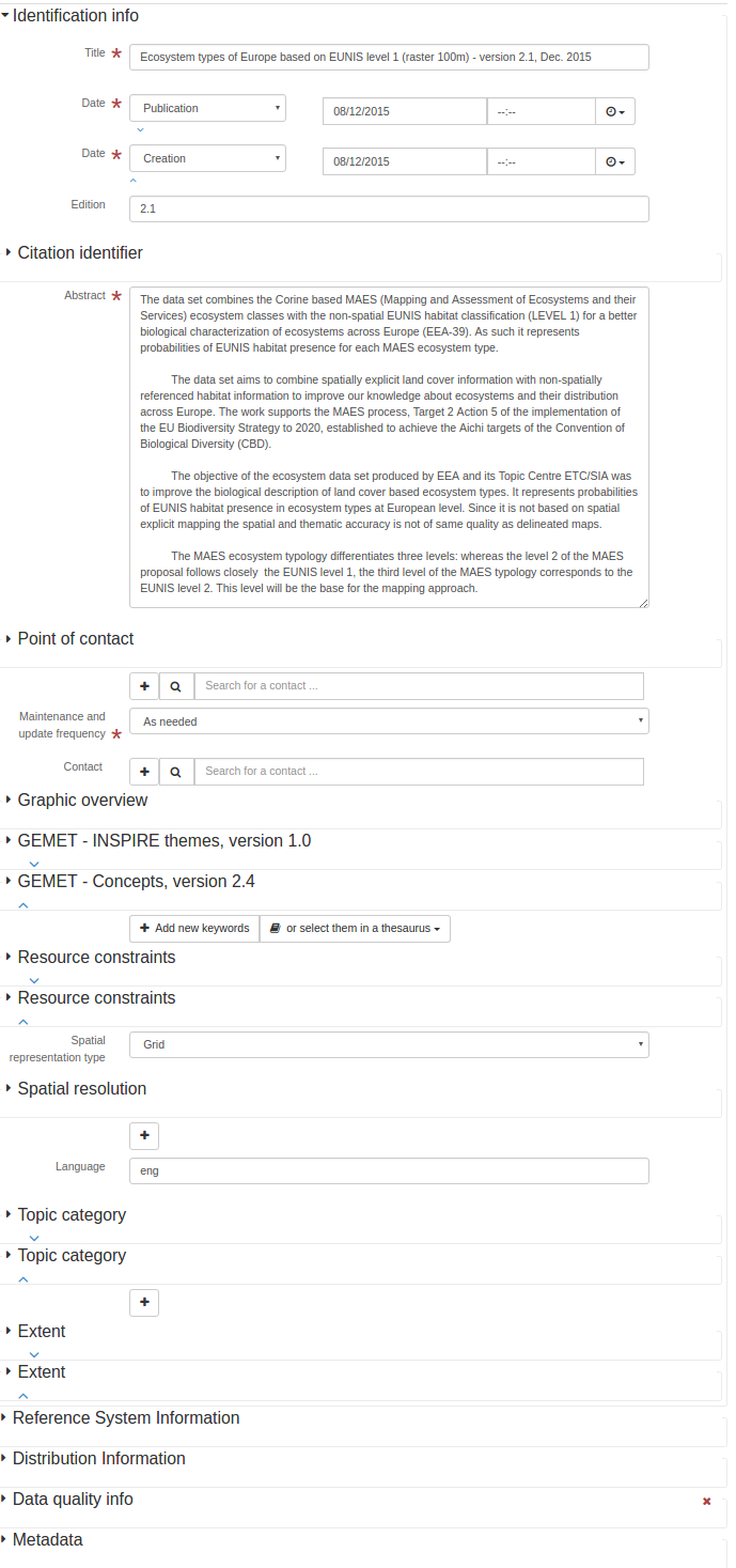
<gmd:abstract>
<gco:CharacterString>The data set combines the Corine based MAES (Mapping and Assessment of
Ecosystems and their Services) ecosystem classes with the non-spatial EUNIS habitat
classification (LEVEL 1) for a better biological characterization of ecosystems across
Europe (EEA-39). As such it represents probabilities of EUNIS habitat presence for each
MAES ecosystem type.
The data set aims to combine spatially explicit land cover information with non-spatially
referenced habitat information to improve our knowledge about ecosystems and their
distribution across Europe. The work supports the MAES process, Target 2 Action 5 of the
implementation of the EU Biodiversity Strategy to 2020, established to achieve the Aichi
targets of the Convention of Biological Diversity (CBD).
The objective of the ecosystem data set produced by EEA and its Topic Centre ETC/SIA was
to improve the biological description of land cover based ecosystem types. It represents
probabilities of EUNIS habitat presence in ecosystem types at European level. Since it is
not based on spatial explicit mapping the spatial and thematic accuracy is not of same
quality as delineated maps.
The MAES ecosystem typology differentiates three levels: whereas the level 2 of the MAES
proposal follows closely the EUNIS level 1, the third level of the MAES typology
corresponds to the EUNIS level 2. This level will be the base for the mapping approach.
</gco:CharacterString>
</gmd:abstract>
<gmd:pointOfContact>
<gmd:CI_ResponsibleParty>
<gmd:organisationName>
<gco:CharacterString>European Environment Agency</gco:CharacterString>
</gmd:organisationName>
<gmd:contactInfo>
<gmd:CI_Contact>
<gmd:address>
<gmd:CI_Address>
<gmd:deliveryPoint>
<gco:CharacterString>Kongens Nytorv 6</gco:CharacterString>
</gmd:deliveryPoint>
<gmd:city>
<gco:CharacterString>Copenhagen</gco:CharacterString>
</gmd:city>
<gmd:administrativeArea>
<gco:CharacterString>K</gco:CharacterString>
</gmd:administrativeArea>
<gmd:postalCode>
<gco:CharacterString>1050</gco:CharacterString>
</gmd:postalCode>
<gmd:country>
<gco:CharacterString>Denmark</gco:CharacterString>
</gmd:country>
<gmd:electronicMailAddress>
<gco:CharacterString>eea.enquiries@eea.europa.eu</gco:CharacterString>
</gmd:electronicMailAddress>
</gmd:CI_Address>
</gmd:address>
<gmd:onlineResource>
<gmd:CI_OnlineResource>
<gmd:linkage>
<gmd:URL>http://www.eea.europa.eu</gmd:URL>
</gmd:linkage>
<gmd:protocol>
<gco:CharacterString>WWW:LINK-1.0-http--link</gco:CharacterString>
</gmd:protocol>
<gmd:name>
<gco:CharacterString>Europen Environment Agency public website
</gco:CharacterString>
</gmd:name>
<gmd:function>
<gmd:CI_OnLineFunctionCode codeList="http://standards.iso.org/ittf/PubliclyAvailableStandards/ISO_19139_Schemas/resources/codelist/ML_gmxCodelists.xml#CI_OnLineFunctionCode"
codeListValue="information"/>
</gmd:function>
</gmd:CI_OnlineResource>
</gmd:onlineResource>
</gmd:CI_Contact>
</gmd:contactInfo>
<gmd:role>
<gmd:CI_RoleCode codeList="http://standards.iso.org/ittf/PubliclyAvailableStandards/ISO_19139_Schemas/resources/codelist/ML_gmxCodelists.xml#CI_RoleCode"
codeListValue="pointOfContact"/>
</gmd:role>
</gmd:CI_ResponsibleParty>
</gmd:pointOfContact>
<gmd:resourceMaintenance>
<gmd:MD_MaintenanceInformation>
<gmd:maintenanceAndUpdateFrequency>
<gmd:MD_MaintenanceFrequencyCode codeList="http://standards.iso.org/ittf/PubliclyAvailableStandards/ISO_19139_Schemas/resources/codelist/ML_gmxCodelists.xml#MD_MaintenanceFrequencyCode"
codeListValue="asNeeded"/>
</gmd:maintenanceAndUpdateFrequency>
</gmd:MD_MaintenanceInformation>
</gmd:resourceMaintenance>
<gmd:graphicOverview>
<gmd:MD_BrowseGraphic>
<gmd:fileName>
<gco:CharacterString>
http://sdi.eea.europa.eu/public/catalogue-graphic-overview/e8a366b7-0029-44d7-ae33-7578253179c0.png
</gco:CharacterString>
</gmd:fileName>
</gmd:MD_BrowseGraphic>
</gmd:graphicOverview>
<gmd:descriptiveKeywords>
<gmd:MD_Keywords>
<gmd:keyword>
<gco:CharacterString>Land cover</gco:CharacterString>
</gmd:keyword>
<gmd:keyword>
<gco:CharacterString>Habitats and biotopes</gco:CharacterString>
</gmd:keyword>
<gmd:type>
<gmd:MD_KeywordTypeCode codeList="http://www.isotc211.org/2005/resources/codeList.xml#MD_KeywordTypeCode"
codeListValue="theme"/>
</gmd:type>
<gmd:thesaurusName>
<gmd:CI_Citation>
<gmd:title>
<gco:CharacterString>GEMET - INSPIRE themes, version 1.0</gco:CharacterString>
</gmd:title>
<gmd:date>
<gmd:CI_Date>
<gmd:date>
<gco:Date>2008-06-01</gco:Date>
</gmd:date>
<gmd:dateType>
<gmd:CI_DateTypeCode codeList="http://standards.iso.org/ittf/PubliclyAvailableStandards/ISO_19139_Schemas/resources/codelist/ML_gmxCodelists.xml#CI_DateTypeCode"
codeListValue="publication"/>
</gmd:dateType>
</gmd:CI_Date>
</gmd:date>
<gmd:identifier>
<gmd:MD_Identifier>
<gmd:code>
<gmx:Anchor xmlns:gmx="http://www.isotc211.org/2005/gmx"
xlink:href="http://sdi.eea.europa.eu/internal-catalogue/srv/eng/thesaurus.download?ref=external.theme.httpinspireeceuropaeutheme-theme">
geonetwork.thesaurus.external.theme.httpinspireeceuropaeutheme-theme
</gmx:Anchor>
</gmd:code>
</gmd:MD_Identifier>
</gmd:identifier>
</gmd:CI_Citation>
</gmd:thesaurusName>
</gmd:MD_Keywords>
</gmd:descriptiveKeywords>
<gmd:descriptiveKeywords>
<gmd:MD_Keywords>
<gmd:keyword>
<gco:CharacterString>ecosystem</gco:CharacterString>
</gmd:keyword>
<gmd:keyword>
<gco:CharacterString>ecosystem type</gco:CharacterString>
</gmd:keyword>
<gmd:keyword>
<gco:CharacterString>land cover</gco:CharacterString>
</gmd:keyword>
<gmd:keyword>
<gco:CharacterString>environmental assessment</gco:CharacterString>
</gmd:keyword>
<gmd:keyword>
<gco:CharacterString>habitat</gco:CharacterString>
</gmd:keyword>
<gmd:type>
<gmd:MD_KeywordTypeCode codeList="http://www.isotc211.org/2005/resources/codeList.xml#MD_KeywordTypeCode"
codeListValue="theme"/>
</gmd:type>
<gmd:thesaurusName>
<gmd:CI_Citation>
<gmd:title>
<gco:CharacterString>GEMET - Concepts, version 2.4</gco:CharacterString>
</gmd:title>
<gmd:date>
<gmd:CI_Date>
<gmd:date>
<gco:Date>2010-01-13</gco:Date>
</gmd:date>
<gmd:dateType>
<gmd:CI_DateTypeCode codeList="http://standards.iso.org/ittf/PubliclyAvailableStandards/ISO_19139_Schemas/resources/codelist/ML_gmxCodelists.xml#CI_DateTypeCode"
codeListValue="publication"/>
</gmd:dateType>
</gmd:CI_Date>
</gmd:date>
<gmd:identifier>
<gmd:MD_Identifier>
<gmd:code>
<gmx:Anchor xmlns:gmx="http://www.isotc211.org/2005/gmx"
xlink:href="http://sdi.eea.europa.eu/internal-catalogue/srv/eng/thesaurus.download?ref=external.theme.gemet">
geonetwork.thesaurus.external.theme.gemet
</gmx:Anchor>
</gmd:code>
</gmd:MD_Identifier>
</gmd:identifier>
</gmd:CI_Citation>
</gmd:thesaurusName>
</gmd:MD_Keywords>
</gmd:descriptiveKeywords>
<gmd:resourceConstraints>
<gmd:MD_Constraints>
<gmd:useLimitation>
<gco:CharacterString>Unless otherwise indicated, re-use of content on the EEA website
for commercial or non-commercial purposes is permitted free of charge, provided that
the source is acknowledged. The EEA re-use policy follows Directive 2003/98/EC of the
European Parliament and the Council on the re-use of public sector information
throughout the European Union and Commission Decision 2006/291/EC, Euratom on the
re-use of Commission information. The EEA accepts no responsibility or liability
whatsoever for the re-use of content accessible on its website. Any inquiries about
re-use of content on the EEA website should be addressed to Ove Caspersen, EEA,
Kongens Nytorv 6, DK-1050 Copenhagen K, Tel +45 33 36 71 00, Fax +45 33 36 71 99,
e-mail copyrights at eea.europa.eu
</gco:CharacterString>
</gmd:useLimitation>
</gmd:MD_Constraints>
</gmd:resourceConstraints>
<gmd:resourceConstraints>
<gmd:MD_LegalConstraints>
<gmd:accessConstraints>
<gmd:MD_RestrictionCode codeList="http://standards.iso.org/ittf/PubliclyAvailableStandards/ISO_19139_Schemas/resources/codelist/ML_gmxCodelists.xml#MD_RestrictionCode"
codeListValue="otherRestrictions"/>
</gmd:accessConstraints>
<gmd:otherConstraints>
<gco:CharacterString>no limitations</gco:CharacterString>
</gmd:otherConstraints>
</gmd:MD_LegalConstraints>
</gmd:resourceConstraints>
<gmd:spatialRepresentationType>
<gmd:MD_SpatialRepresentationTypeCode codeList="http://standards.iso.org/ittf/PubliclyAvailableStandards/ISO_19139_Schemas/resources/codelist/ML_gmxCodelists.xml#MD_SpatialRepresentationTypeCode"
codeListValue="grid"/>
</gmd:spatialRepresentationType>
<gmd:spatialResolution>
<gmd:MD_Resolution>
<gmd:distance>
<gco:Distance uom="m">100</gco:Distance>
</gmd:distance>
</gmd:MD_Resolution>
</gmd:spatialResolution>
<gmd:language>
<gmd:LanguageCode codeList="http://www.loc.gov/standards/iso639-2/" codeListValue="eng"/>
</gmd:language>
<gmd:topicCategory>
<gmd:MD_TopicCategoryCode>biota</gmd:MD_TopicCategoryCode>
</gmd:topicCategory>
<gmd:topicCategory>
<gmd:MD_TopicCategoryCode>environment</gmd:MD_TopicCategoryCode>
</gmd:topicCategory>
<gmd:extent>
<gmd:EX_Extent>
<gmd:geographicElement>
<gmd:EX_GeographicBoundingBox>
<gmd:westBoundLongitude>
<gco:Decimal>-33.90432</gco:Decimal>
</gmd:westBoundLongitude>
<gmd:eastBoundLongitude>
<gco:Decimal>38.1471</gco:Decimal>
</gmd:eastBoundLongitude>
<gmd:southBoundLatitude>
<gco:Decimal>26.988714</gco:Decimal>
</gmd:southBoundLatitude>
<gmd:northBoundLatitude>
<gco:Decimal>60.57849</gco:Decimal>
</gmd:northBoundLatitude>
</gmd:EX_GeographicBoundingBox>
</gmd:geographicElement>
</gmd:EX_Extent>
</gmd:extent>
<gmd:extent>
<gmd:EX_Extent>
<gmd:temporalElement>
<gmd:EX_TemporalExtent>
<gmd:extent>
<gml:TimePeriod gml:id="d28e322a1049886">
<gml:beginPosition>2006-01-01</gml:beginPosition>
<gml:endPosition>2006-12-31</gml:endPosition>
</gml:TimePeriod>
</gmd:extent>
</gmd:EX_TemporalExtent>
</gmd:temporalElement>
</gmd:EX_Extent>
</gmd:extent>
</gmd:MD_DataIdentification>
</gmd:identificationInfo>
标识符
- 名字
gmd:标识符
- 描述
引文标识符
- 名字
gmd:标识符
- 语境
gmd:引文
- 描述
照明方位角
- 名字
gmd:光照角
- 描述
照明仰角
- 名字
gmd:照明角度
- 描述
图像质量代码
- 名字
gmd:图像质量代码
- 描述
成像条件
- 名字
gmd:想象条件
- 描述
包含在数据集中
- 名字
gmd:包含在数据集中
- 描述
- 条件
强制性的
<gmd:includedWithDataset xmlns:gmd="http://www.isotc211.org/2005/gmd" xmlns:gml="http://www.opengis.net/gml"
                         xmlns:xlink="http://www.w3.org/1999/xlink">
   <gco:Boolean>false</gco:Boolean>
</gmd:includedWithDataset>
个人姓名
- 名字
gmd:个人姓名
- 描述
主动类型
- 名字
gmd:启动类型
- 描述
ISBN
- 名字
gmd:ISBN
- 描述
ISSN
- 名字
gmd:ISSN公司
- 描述
问题识别
- 名字
gmd:发行识别
- 描述
关键字
- 名字
gmd:关键字
- 描述
元数据语言
- 名字
gmd:语言
- 描述
- 条件
有条件的
语言
- 名字
gmd:语言
- 语境
gmd:MD U数据标识
- 描述
语言
- 名字
gmd:语言
- 语境
gmd:MD U功能目录描述
- 描述
语言
- 名字
gmd:语言代码
- 描述
ISO语言代码
- 名字
gmd:语言代码
- 描述
镜头畸变信息可用性
- 名字
gmd:LensDistorationInformation可用性
- 描述
层次结构级别
- 名字
gmd:水平
- 描述
- 条件
强制性的
<gmd:level xmlns:gmd="http://www.isotc211.org/2005/gmd" xmlns:gml="http://www.opengis.net/gml"
           xmlns:xlink="http://www.w3.org/1999/xlink">
   <gmd:MD_ScopeCode codeListValue="dataset"
                     codeList="http://standards.iso.org/ittf/PubliclyAvailableStandards/ISO_19139_Schemas/resources/codelist/ML_gmxCodelists.xml#MD_ScopeCode"/>
</gmd:level>
级别说明
- 名字
gmd:级别描述
- 描述
血统
- 名字
gmd:李琰世系
- 描述
<gmd:LI_Lineage xmlns:gmd="http://www.isotc211.org/2005/gmd" xmlns:gml="http://www.opengis.net/gml"
                xmlns:xlink="http://www.w3.org/1999/xlink">
   <gmd:statement>
      <gco:CharacterString>The data set production implied 2 steps. First re-classification of
              CORINE Land Cover 2006 and bathymetry data using the 7 terrestrial (urban, cropland,
              grassland, woodland and forest, heathland and shrub, sparsely vegetated land,
              wetland), 1 freshwater (river and lakes), and 4 marine (marine inlets and transitional
              waters, coastal, shelf, open ocean) classes of the MAES ecosystem typology (Maes et
              al., 2013). The classes also provide links to major policy lines such as agriculture,
              forestry, territorial cohesion, water and marine related policies. The second step
              comprised refinement of the ecosystem types by attributing EUNIS habitat information
              to each ecosystem type (see http://eunis.eea.europa.eu/habitats.jsp). The refinement
              process used reference data such as potential natural vegetation, elevation, slope,
              aspect, soil, geology, environmental regions and other spatial referenced information
              which allowed attribution of the EUNIS habitat characteristics to the spatial mapping
              units of the MAES ecosystem types. The geometric and thematic accuracy of EUNIS class
              presence was also estimated and mapped. The method is described in the EEA Technical
              Report 06/2015: European Ecosystem Assessment – Concept, Data, and Implementation.
              The basis for the update was CORINE land cover 2006 (CLC 2006). It includes Albania,
              Austria, Belgium, Bosnia and Herzegovina, Bulgaria, Croatia, Cyprus, Czech Republic,
              Denmark, Estonia, Finland, France, Germany, Hungary, Iceland, Ireland, Italy, Kosovo
              (under UNSCR 1244/99), Latvia, Liechtenstein, Lithuania, Luxembourg, the former
              Yugoslavian Republic of Macedonia, Malta, Montenegro, the Netherlands, Norway, Poland,
              Portugal, Romania, Serbia, Slovakia, Slovenia, Spain, Sweden, Switzerland, Turkey and
              the United Kingdom. For Greece that has not participated in the CLC 2006 activity the
              CLC 2000 data was used instead.
            </gco:CharacterString>
   </gmd:statement>
   <gmd:source uuidref="bacb0dcd-dcb2-44a5-8b2c-4a569c5deafa"/>
</gmd:LI_Lineage>
工艺步骤
- 名字
gmd:LIúu流程步骤
- 描述
来源
- 名字
gmd:LIúu来源
- 描述
血统
- 名字
gmd:血统
- 描述
<gmd:lineage xmlns:gmd="http://www.isotc211.org/2005/gmd" xmlns:gml="http://www.opengis.net/gml"
             xmlns:xlink="http://www.w3.org/1999/xlink">
   <gmd:LI_Lineage>
      <gmd:statement>
         <gco:CharacterString>The data set production implied 2 steps. First re-classification of
              CORINE Land Cover 2006 and bathymetry data using the 7 terrestrial (urban, cropland,
              grassland, woodland and forest, heathland and shrub, sparsely vegetated land,
              wetland), 1 freshwater (river and lakes), and 4 marine (marine inlets and transitional
              waters, coastal, shelf, open ocean) classes of the MAES ecosystem typology (Maes et
              al., 2013). The classes also provide links to major policy lines such as agriculture,
              forestry, territorial cohesion, water and marine related policies. The second step
              comprised refinement of the ecosystem types by attributing EUNIS habitat information
              to each ecosystem type (see http://eunis.eea.europa.eu/habitats.jsp). The refinement
              process used reference data such as potential natural vegetation, elevation, slope,
              aspect, soil, geology, environmental regions and other spatial referenced information
              which allowed attribution of the EUNIS habitat characteristics to the spatial mapping
              units of the MAES ecosystem types. The geometric and thematic accuracy of EUNIS class
              presence was also estimated and mapped. The method is described in the EEA Technical
              Report 06/2015: European Ecosystem Assessment – Concept, Data, and Implementation.
              The basis for the update was CORINE land cover 2006 (CLC 2006). It includes Albania,
              Austria, Belgium, Bosnia and Herzegovina, Bulgaria, Croatia, Cyprus, Czech Republic,
              Denmark, Estonia, Finland, France, Germany, Hungary, Iceland, Ireland, Italy, Kosovo
              (under UNSCR 1244/99), Latvia, Liechtenstein, Lithuania, Luxembourg, the former
              Yugoslavian Republic of Macedonia, Malta, Montenegro, the Netherlands, Norway, Poland,
              Portugal, Romania, Serbia, Slovakia, Slovenia, Spain, Sweden, Switzerland, Turkey and
              the United Kingdom. For Greece that has not participated in the CLC 2006 activity the
              CLC 2000 data was used instead.
            </gco:CharacterString>
      </gmd:statement>
      <gmd:source uuidref="bacb0dcd-dcb2-44a5-8b2c-4a569c5deafa"/>
   </gmd:LI_Lineage>
</gmd:lineage>
连接
- 名字
gmd:联动
- 描述
- 条件
强制性的
其他语言
- 名字
gmd:区域设置
- 描述
局部字符串
- 名字
gmd:局部字符字符串
- 描述
局部字符串
- 名字
gmd:本地化字符串
- 描述
维护和更新频率
- 名字
gmd:维护和更新频率
- 描述
- 条件
强制性的
<gmd:maintenanceAndUpdateFrequency xmlns:gmd="http://www.isotc211.org/2005/gmd" xmlns:gml="http://www.opengis.net/gml"
                                   xmlns:xlink="http://www.w3.org/1999/xlink">
   <gmd:MD_MaintenanceFrequencyCode codeList="http://standards.iso.org/ittf/PubliclyAvailableStandards/ISO_19139_Schemas/resources/codelist/ML_gmxCodelists.xml#MD_MaintenanceFrequencyCode"
                                    codeListValue="asNeeded"/>
</gmd:maintenanceAndUpdateFrequency>
维护说明
- 名字
gmd:维护
- 描述
最大发生次数
- 名字
gmd:最大出现次数
- 描述
最大值
- 名字
gmd:最大值
- 描述
- 条件
强制性的
最大值
- 名字
gmd:最大值
- 描述
聚合信息
- 名字
gmd:MD_聚合信息
- 描述
应用程序架构信息
- 名字
gmd:MD U应用程序模式信息
- 描述
波段
- 名字
gmd:MD U波段
- 描述
浏览图形
- 名字
gmd:MD_BrowseGraphic公司
- 描述
<gmd:MD_BrowseGraphic xmlns:gmd="http://www.isotc211.org/2005/gmd" xmlns:gml="http://www.opengis.net/gml"
                      xmlns:xlink="http://www.w3.org/1999/xlink">
   <gmd:fileName>
      <gco:CharacterString>
              http://sdi.eea.europa.eu/public/catalogue-graphic-overview/e8a366b7-0029-44d7-ae33-7578253179c0.png
            </gco:CharacterString>
   </gmd:fileName>
</gmd:MD_BrowseGraphic>
单元几何代码
- 名字
gmd:MD_CellGeometryCode公司
- 描述
标准代码表单元格几何代码(gmd:MD_CellGeometryCode公司)
代码 |
标签 |
描述 |
|---|---|---|
点 |
Point |
每个单元格代表一个点 |
地区 |
地区 |
每个单元格代表一个区域 |
字符集代码
- 名字
gmd:MD字符集代码
- 描述
标准代码列表字符集代码(gmd:MD字符集代码)
代码 |
标签 |
描述 |
|---|---|---|
ucs2标准 |
UCS2 |
基于ISO/IEC 10646的16位固定大小通用字符集 |
ucs4标准 |
UCS4标准 |
基于ISO/IEC 10646的32位固定大小通用字符集 |
utf7标准 |
UTF7标准 |
基于ISO/IEC 10646的7位可变大小UCS传输格式 |
utf8型 |
UTF8 |
8位可变大小UCS传输格式,基于ISO/IEC 10646 |
utf16型 |
UTF16 |
16位可变大小UCS传输格式,基于ISO/IEC 10646 |
8859第1部分 |
8859第1部分 |
信息技术8位单字节编码图形字符集第1部分:拉丁字母1 |
8859第2部分 |
8859第2部分 |
信息技术8位单字节编码图形字符集第2部分:拉丁字母2 |
8859第3部分 |
8859第3部分 |
信息技术8位单字节编码图形字符集第3部分:拉丁字母3 |
8859第4部分 |
8859第4部分 |
信息技术8位单字节编码图形字符集第4部分:拉丁字母4 |
8859第5部分 |
8859第5部分 |
信息技术8位单字节编码图形字符集第5部分:拉丁/西里尔字母 |
8859第6部分 |
8859第6部分 |
信息技术8位单字节编码图形字符集第6部分:拉丁/阿拉伯字母 |
8859第7部分 |
8859第7部分 |
信息技术8位单字节编码图形字符集第7部分:拉丁/希腊字母 |
8859第8部分 |
8859第8部分 |
信息技术8位单字节编码图形字符集第8部分:拉丁/希伯来字母 |
8859第9部分 |
8859第9部分 |
信息技术8位单字节编码图形字符集第9部分:拉丁字母5 |
8859第10部分 |
8859第10部分 |
信息技术8位单字节编码图形字符集第10部分:6号拉丁字母 |
8859第11部分 |
8859第11部分 |
信息技术8位单字节编码图形字符集第11部分:拉丁/泰语字母 |
8859第13部分 |
8859第13部分 |
信息技术8位单字节编码图形字符集第13部分:第7号拉丁字母 |
8859第14部分 |
8859第14部分 |
ISO/IEC 8859-14,信息技术.8位单字节编码图形字符集.第14部分:8号拉丁字母(凯尔特语) |
8859第15部分 |
8859第15部分 |
信息技术8位单字节编码图形字符集第15部分:9号拉丁字母 |
8859第16部分 |
8859第16部分 |
信息技术8位单字节编码图形字符集第16部分:拉丁字母10 |
JIS |
JIS |
用于电子传输的日文代码集 |
轮班 |
班次JIS |
MS-DOS计算机上使用的日语代码集 |
EGJP |
EUC日元 |
在基于UNIX的机器上使用的日语代码集 |
乌萨西 |
美国ASCII码 |
美国ASCII码集(ISO 646 US) |
ebcdic公司 |
EBCDIC |
IBM大型机代码集 |
欧克朗 |
EUC克朗 |
朝鲜语代码集 |
Big5 |
大5 |
中国传统代码集在台湾、中国香港等地区使用 |
GB2312标准 |
GB2312标准 |
简体中文代码集 |
<gmd:MD_CharacterSetCode xmlns:gmd="http://www.isotc211.org/2005/gmd" xmlns:gml="http://www.opengis.net/gml"
                         codeList="http://standards.iso.org/ittf/PubliclyAvailableStandards/ISO_19139_Schemas/resources/codelist/ML_gmxCodelists.xml#MD_CharacterSetCode"
                         codeListValue="utf8"/>
分类代码
- 名字
gmd:MD U分类代码
- 描述
标准代码表分类代码(gmd:MD U分类代码)
代码 |
标签 |
描述 |
|---|---|---|
未分类 |
未分类 |
可供一般披露 |
受限制的 |
受限制的 |
不作一般披露 |
机密 |
机密 |
提供给可以被委托提供信息的人 |
秘密 |
秘密 |
保密的保密的或打算保密的、不为人所知的或对所有人隐藏的 |
绝密 |
绝密 |
最高机密 |
约束条件
- 名字
gmd:MD_约束
- 描述
<gmd:MD_Constraints xmlns:gmd="http://www.isotc211.org/2005/gmd" xmlns:gml="http://www.opengis.net/gml"
                    xmlns:xlink="http://www.w3.org/1999/xlink">
   <gmd:useLimitation>
      <gco:CharacterString>Unless otherwise indicated, re-use of content on the EEA website
              for commercial or non-commercial purposes is permitted free of charge, provided that
              the source is acknowledged. The EEA re-use policy follows Directive 2003/98/EC of the
              European Parliament and the Council on the re-use of public sector information
              throughout the European Union and Commission Decision 2006/291/EC, Euratom on the
              re-use of Commission information. The EEA accepts no responsibility or liability
              whatsoever for the re-use of content accessible on its website. Any inquiries about
              re-use of content on the EEA website should be addressed to Ove Caspersen, EEA,
              Kongens Nytorv 6, DK-1050 Copenhagen K, Tel +45 33 36 71 00, Fax +45 33 36 71 99,
              e-mail copyrights at eea.europa.eu
            </gco:CharacterString>
   </gmd:useLimitation>
</gmd:MD_Constraints>
内容类型代码
- 名字
gmd:MD_覆盖内容类型代码
- 描述
标准代码列表内容类型代码(gmd:MD_覆盖内容类型代码)
代码 |
标签 |
描述 |
|---|---|---|
形象 |
图像 |
非物理参数实际值的物理参数的有意义的数值表示 |
主题分类 |
专题分类 |
无数量意义的代码值,用于表示物理量 |
物理测量 |
物理测量 |
被测数量的物理单位值 |
覆盖范围描述
- 名字
gmd:MD U覆盖范围描述
- 描述
数据标识
- 名字
gmd:MD U数据标识
- 描述
<gmd:MD_DataIdentification xmlns:gmd="http://www.isotc211.org/2005/gmd" xmlns:gml="http://www.opengis.net/gml"
                           xmlns:xlink="http://www.w3.org/1999/xlink">
   <gmd:citation>
      <gmd:CI_Citation>
         <gmd:title>
            <gco:CharacterString>Ecosystem types of Europe based on EUNIS level 1 (raster 100m) -
              version 2.1, Dec. 2015
            </gco:CharacterString>
         </gmd:title>
         <gmd:date>
            <gmd:CI_Date>
               <gmd:date>
                  <gco:Date>2015-12-08</gco:Date>
               </gmd:date>
               <gmd:dateType>
                  <gmd:CI_DateTypeCode codeList="http://standards.iso.org/ittf/PubliclyAvailableStandards/ISO_19139_Schemas/resources/codelist/ML_gmxCodelists.xml#CI_DateTypeCode"
                                       codeListValue="publication"/>
               </gmd:dateType>
            </gmd:CI_Date>
         </gmd:date>
         <gmd:date>
            <gmd:CI_Date>
               <gmd:date>
                  <gco:Date>2015-12-08</gco:Date>
               </gmd:date>
               <gmd:dateType>
                  <gmd:CI_DateTypeCode codeList="http://standards.iso.org/ittf/PubliclyAvailableStandards/ISO_19139_Schemas/resources/codelist/ML_gmxCodelists.xml#CI_DateTypeCode"
                                       codeListValue="creation"/>
               </gmd:dateType>
            </gmd:CI_Date>
         </gmd:date>
         <gmd:edition>
            <gco:CharacterString>2.1</gco:CharacterString>
         </gmd:edition>
         <gmd:identifier>
            <gmd:RS_Identifier>
               <gmd:code>
                  <gco:CharacterString>eea_r_3035_100_m_ecosystem-types-l1_2006_rev2-1
                </gco:CharacterString>
               </gmd:code>
            </gmd:RS_Identifier>
         </gmd:identifier>
      </gmd:CI_Citation>
   </gmd:citation>
   <gmd:abstract>
      <gco:CharacterString>The data set combines the Corine based MAES (Mapping and Assessment of
          Ecosystems and their Services) ecosystem classes with the non-spatial EUNIS habitat
          classification (LEVEL 1) for a better biological characterization of ecosystems across
          Europe (EEA-39). As such it represents probabilities of EUNIS habitat presence for each
          MAES ecosystem type.

          The data set aims to combine spatially explicit land cover information with non-spatially
          referenced habitat information to improve our knowledge about ecosystems and their
          distribution across Europe. The work supports the MAES process, Target 2 Action 5 of the
          implementation of the EU Biodiversity Strategy to 2020, established to achieve the Aichi
          targets of the Convention of Biological Diversity (CBD).

          The objective of the ecosystem data set produced by EEA and its Topic Centre ETC/SIA was
          to improve the biological description of land cover based ecosystem types. It represents
          probabilities of EUNIS habitat presence in ecosystem types at European level. Since it is
          not based on spatial explicit mapping the spatial and thematic accuracy is not of same
          quality as delineated maps.

          The MAES ecosystem typology differentiates three levels: whereas the level 2 of the MAES
          proposal follows closely the EUNIS level 1, the third level of the MAES typology
          corresponds to the EUNIS level 2. This level will be the base for the mapping approach.
        </gco:CharacterString>
   </gmd:abstract>
   <gmd:pointOfContact>
      <gmd:CI_ResponsibleParty>
         <gmd:organisationName>
            <gco:CharacterString>European Environment Agency</gco:CharacterString>
         </gmd:organisationName>
         <gmd:contactInfo>
            <gmd:CI_Contact>
               <gmd:address>
                  <gmd:CI_Address>
                     <gmd:deliveryPoint>
                        <gco:CharacterString>Kongens Nytorv 6</gco:CharacterString>
                     </gmd:deliveryPoint>
                     <gmd:city>
                        <gco:CharacterString>Copenhagen</gco:CharacterString>
                     </gmd:city>
                     <gmd:administrativeArea>
                        <gco:CharacterString>K</gco:CharacterString>
                     </gmd:administrativeArea>
                     <gmd:postalCode>
                        <gco:CharacterString>1050</gco:CharacterString>
                     </gmd:postalCode>
                     <gmd:country>
                        <gco:CharacterString>Denmark</gco:CharacterString>
                     </gmd:country>
                     <gmd:electronicMailAddress>
                        <gco:CharacterString>eea.enquiries@eea.europa.eu</gco:CharacterString>
                     </gmd:electronicMailAddress>
                  </gmd:CI_Address>
               </gmd:address>
               <gmd:onlineResource>
                  <gmd:CI_OnlineResource>
                     <gmd:linkage>
                        <gmd:URL>http://www.eea.europa.eu</gmd:URL>
                     </gmd:linkage>
                     <gmd:protocol>
                        <gco:CharacterString>WWW:LINK-1.0-http--link</gco:CharacterString>
                     </gmd:protocol>
                     <gmd:name>
                        <gco:CharacterString>Europen Environment Agency public website
                    </gco:CharacterString>
                     </gmd:name>
                     <gmd:function>
                        <gmd:CI_OnLineFunctionCode codeList="http://standards.iso.org/ittf/PubliclyAvailableStandards/ISO_19139_Schemas/resources/codelist/ML_gmxCodelists.xml#CI_OnLineFunctionCode"
                                                   codeListValue="information"/>
                     </gmd:function>
                  </gmd:CI_OnlineResource>
               </gmd:onlineResource>
            </gmd:CI_Contact>
         </gmd:contactInfo>
         <gmd:role>
            <gmd:CI_RoleCode codeList="http://standards.iso.org/ittf/PubliclyAvailableStandards/ISO_19139_Schemas/resources/codelist/ML_gmxCodelists.xml#CI_RoleCode"
                             codeListValue="pointOfContact"/>
         </gmd:role>
      </gmd:CI_ResponsibleParty>
   </gmd:pointOfContact>
   <gmd:resourceMaintenance>
      <gmd:MD_MaintenanceInformation>
         <gmd:maintenanceAndUpdateFrequency>
            <gmd:MD_MaintenanceFrequencyCode codeList="http://standards.iso.org/ittf/PubliclyAvailableStandards/ISO_19139_Schemas/resources/codelist/ML_gmxCodelists.xml#MD_MaintenanceFrequencyCode"
                                             codeListValue="asNeeded"/>
         </gmd:maintenanceAndUpdateFrequency>
      </gmd:MD_MaintenanceInformation>
   </gmd:resourceMaintenance>
   <gmd:graphicOverview>
      <gmd:MD_BrowseGraphic>
         <gmd:fileName>
            <gco:CharacterString>
              http://sdi.eea.europa.eu/public/catalogue-graphic-overview/e8a366b7-0029-44d7-ae33-7578253179c0.png
            </gco:CharacterString>
         </gmd:fileName>
      </gmd:MD_BrowseGraphic>
   </gmd:graphicOverview>
   <gmd:descriptiveKeywords>
      <gmd:MD_Keywords>
         <gmd:keyword>
            <gco:CharacterString>Land cover</gco:CharacterString>
         </gmd:keyword>
         <gmd:keyword>
            <gco:CharacterString>Habitats and biotopes</gco:CharacterString>
         </gmd:keyword>
         <gmd:type>
            <gmd:MD_KeywordTypeCode codeList="http://www.isotc211.org/2005/resources/codeList.xml#MD_KeywordTypeCode"
                                    codeListValue="theme"/>
         </gmd:type>
         <gmd:thesaurusName>
            <gmd:CI_Citation>
               <gmd:title>
                  <gco:CharacterString>GEMET - INSPIRE themes, version 1.0</gco:CharacterString>
               </gmd:title>
               <gmd:date>
                  <gmd:CI_Date>
                     <gmd:date>
                        <gco:Date>2008-06-01</gco:Date>
                     </gmd:date>
                     <gmd:dateType>
                        <gmd:CI_DateTypeCode codeList="http://standards.iso.org/ittf/PubliclyAvailableStandards/ISO_19139_Schemas/resources/codelist/ML_gmxCodelists.xml#CI_DateTypeCode"
                                             codeListValue="publication"/>
                     </gmd:dateType>
                  </gmd:CI_Date>
               </gmd:date>
               <gmd:identifier>
                  <gmd:MD_Identifier>
                     <gmd:code>
                        <gmx:Anchor xmlns:gmx="http://www.isotc211.org/2005/gmx"
                                    xlink:href="http://sdi.eea.europa.eu/internal-catalogue/srv/eng/thesaurus.download?ref=external.theme.httpinspireeceuropaeutheme-theme">
                      geonetwork.thesaurus.external.theme.httpinspireeceuropaeutheme-theme
                    </gmx:Anchor>
                     </gmd:code>
                  </gmd:MD_Identifier>
               </gmd:identifier>
            </gmd:CI_Citation>
         </gmd:thesaurusName>
      </gmd:MD_Keywords>
   </gmd:descriptiveKeywords>
   <gmd:descriptiveKeywords>
      <gmd:MD_Keywords>
         <gmd:keyword>
            <gco:CharacterString>ecosystem</gco:CharacterString>
         </gmd:keyword>
         <gmd:keyword>
            <gco:CharacterString>ecosystem type</gco:CharacterString>
         </gmd:keyword>
         <gmd:keyword>
            <gco:CharacterString>land cover</gco:CharacterString>
         </gmd:keyword>
         <gmd:keyword>
            <gco:CharacterString>environmental assessment</gco:CharacterString>
         </gmd:keyword>
         <gmd:keyword>
            <gco:CharacterString>habitat</gco:CharacterString>
         </gmd:keyword>
         <gmd:type>
            <gmd:MD_KeywordTypeCode codeList="http://www.isotc211.org/2005/resources/codeList.xml#MD_KeywordTypeCode"
                                    codeListValue="theme"/>
         </gmd:type>
         <gmd:thesaurusName>
            <gmd:CI_Citation>
               <gmd:title>
                  <gco:CharacterString>GEMET - Concepts, version 2.4</gco:CharacterString>
               </gmd:title>
               <gmd:date>
                  <gmd:CI_Date>
                     <gmd:date>
                        <gco:Date>2010-01-13</gco:Date>
                     </gmd:date>
                     <gmd:dateType>
                        <gmd:CI_DateTypeCode codeList="http://standards.iso.org/ittf/PubliclyAvailableStandards/ISO_19139_Schemas/resources/codelist/ML_gmxCodelists.xml#CI_DateTypeCode"
                                             codeListValue="publication"/>
                     </gmd:dateType>
                  </gmd:CI_Date>
               </gmd:date>
               <gmd:identifier>
                  <gmd:MD_Identifier>
                     <gmd:code>
                        <gmx:Anchor xmlns:gmx="http://www.isotc211.org/2005/gmx"
                                    xlink:href="http://sdi.eea.europa.eu/internal-catalogue/srv/eng/thesaurus.download?ref=external.theme.gemet">
                      geonetwork.thesaurus.external.theme.gemet
                    </gmx:Anchor>
                     </gmd:code>
                  </gmd:MD_Identifier>
               </gmd:identifier>
            </gmd:CI_Citation>
         </gmd:thesaurusName>
      </gmd:MD_Keywords>
   </gmd:descriptiveKeywords>
   <gmd:resourceConstraints>
      <gmd:MD_Constraints>
         <gmd:useLimitation>
            <gco:CharacterString>Unless otherwise indicated, re-use of content on the EEA website
              for commercial or non-commercial purposes is permitted free of charge, provided that
              the source is acknowledged. The EEA re-use policy follows Directive 2003/98/EC of the
              European Parliament and the Council on the re-use of public sector information
              throughout the European Union and Commission Decision 2006/291/EC, Euratom on the
              re-use of Commission information. The EEA accepts no responsibility or liability
              whatsoever for the re-use of content accessible on its website. Any inquiries about
              re-use of content on the EEA website should be addressed to Ove Caspersen, EEA,
              Kongens Nytorv 6, DK-1050 Copenhagen K, Tel +45 33 36 71 00, Fax +45 33 36 71 99,
              e-mail copyrights at eea.europa.eu
            </gco:CharacterString>
         </gmd:useLimitation>
      </gmd:MD_Constraints>
   </gmd:resourceConstraints>
   <gmd:resourceConstraints>
      <gmd:MD_LegalConstraints>
         <gmd:accessConstraints>
            <gmd:MD_RestrictionCode codeList="http://standards.iso.org/ittf/PubliclyAvailableStandards/ISO_19139_Schemas/resources/codelist/ML_gmxCodelists.xml#MD_RestrictionCode"
                                    codeListValue="otherRestrictions"/>
         </gmd:accessConstraints>
         <gmd:otherConstraints>
            <gco:CharacterString>no limitations</gco:CharacterString>
         </gmd:otherConstraints>
      </gmd:MD_LegalConstraints>
   </gmd:resourceConstraints>
   <gmd:spatialRepresentationType>
      <gmd:MD_SpatialRepresentationTypeCode codeList="http://standards.iso.org/ittf/PubliclyAvailableStandards/ISO_19139_Schemas/resources/codelist/ML_gmxCodelists.xml#MD_SpatialRepresentationTypeCode"
                                            codeListValue="grid"/>
   </gmd:spatialRepresentationType>
   <gmd:spatialResolution>
      <gmd:MD_Resolution>
         <gmd:distance>
            <gco:Distance uom="m">100</gco:Distance>
         </gmd:distance>
      </gmd:MD_Resolution>
   </gmd:spatialResolution>
   <gmd:language>
      <gmd:LanguageCode codeList="http://www.loc.gov/standards/iso639-2/" codeListValue="eng"/>
   </gmd:language>
   <gmd:topicCategory>
      <gmd:MD_TopicCategoryCode>biota</gmd:MD_TopicCategoryCode>
   </gmd:topicCategory>
   <gmd:topicCategory>
      <gmd:MD_TopicCategoryCode>environment</gmd:MD_TopicCategoryCode>
   </gmd:topicCategory>
   <gmd:extent>
      <gmd:EX_Extent>
         <gmd:geographicElement>
            <gmd:EX_GeographicBoundingBox>
               <gmd:westBoundLongitude>
                  <gco:Decimal>-33.90432</gco:Decimal>
               </gmd:westBoundLongitude>
               <gmd:eastBoundLongitude>
                  <gco:Decimal>38.1471</gco:Decimal>
               </gmd:eastBoundLongitude>
               <gmd:southBoundLatitude>
                  <gco:Decimal>26.988714</gco:Decimal>
               </gmd:southBoundLatitude>
               <gmd:northBoundLatitude>
                  <gco:Decimal>60.57849</gco:Decimal>
               </gmd:northBoundLatitude>
            </gmd:EX_GeographicBoundingBox>
         </gmd:geographicElement>
      </gmd:EX_Extent>
   </gmd:extent>
   <gmd:extent>
      <gmd:EX_Extent>
         <gmd:temporalElement>
            <gmd:EX_TemporalExtent>
               <gmd:extent>
                  <gml:TimePeriod gml:id="d28e322a1049886">
                     <gml:beginPosition>2006-01-01</gml:beginPosition>
                     <gml:endPosition>2006-12-31</gml:endPosition>
                  </gml:TimePeriod>
               </gmd:extent>
            </gmd:EX_TemporalExtent>
         </gmd:temporalElement>
      </gmd:EX_Extent>
   </gmd:extent>
</gmd:MD_DataIdentification>
数据类型代码
- 名字
gmd:MD U数据类型代码
- 描述
标准代码表数据类型代码(gmd:MD U数据类型代码)
代码 |
标签 |
描述 |
|---|---|---|
类 |
等级 |
共享相同属性、操作、方法、关系和行为的一组对象的描述符 |
代码表 |
代码表 |
共享相同属性、操作、方法、关系和行为的一组对象的描述符 |
枚举 |
枚举 |
其实例构成命名文本值列表的数据类型,不可扩展 |
代码列表元素 |
代码列表元素 |
代码表或枚举的允许值 |
抽象类 |
抽象类 |
无法直接实例化的类 |
聚合类 |
聚合类 |
由它通过聚合关系连接到的类组成的类 |
指定类 |
指定类 |
可替代其超类的子类 |
数据类型类 |
数据类型类 |
很少或没有操作的类,其主要目的是保存另一个类的抽象状态以供传递、存储、编码或持久存储 |
接口类 |
接口类 |
描述元素行为的命名操作集 |
联合阶级 |
联合类 |
类描述指定类型之一的选择 |
元类 |
元类 |
实例为类的类 |
类型类 |
类型类 |
类,用于指定实例(对象)的域以及适用于对象的操作。类型可以有属性和关联 |
字符字符串 |
字符串 |
自由文本字段 |
整数 |
整数 |
数值场 |
协会 |
协会 |
涉及实例间连接的两个类之间的语义关系 |
数字传输选项
- 名字
gmd:MD U数字传输选项
- 描述
<gmd:MD_DigitalTransferOptions xmlns:gmd="http://www.isotc211.org/2005/gmd" xmlns:gml="http://www.opengis.net/gml"
                               xmlns:xlink="http://www.w3.org/1999/xlink">
   <gmd:onLine>
      <gmd:CI_OnlineResource>
         <gmd:linkage>
            <gmd:URL>
                  http://www.eea.europa.eu/data-and-maps/data/ds_resolveuid/d851e1b7f678468b8f0b1b98930ba3e1
                </gmd:URL>
         </gmd:linkage>
         <gmd:protocol>
            <gco:CharacterString>WWW:LINK-1.0-http--link</gco:CharacterString>
         </gmd:protocol>
         <gmd:function>
            <gmd:CI_OnLineFunctionCode codeList="http://standards.iso.org/ittf/PubliclyAvailableStandards/ISO_19139_Schemas/resources/codelist/ML_gmxCodelists.xml#CI_OnLineFunctionCode"
                                       codeListValue="download"/>
         </gmd:function>
      </gmd:CI_OnlineResource>
   </gmd:onLine>
</gmd:MD_DigitalTransferOptions>
尺寸
- 名字
gmd:MD_维度
- 描述
维度类型代码
- 名字
gmd:MD U尺寸名称类型代码
- 描述
标准代码表尺寸类型代码(gmd:MD U尺寸名称类型代码)
代码 |
标签 |
描述 |
|---|---|---|
行 |
排 |
纵坐标(y)轴 |
柱 |
柱 |
横坐标轴 |
垂直的 |
垂直 |
垂直(z)轴 |
轨道 |
轨道 |
沿着扫描点的运动方向 |
交叉线 |
横道 |
垂直于扫描点的运动方向 |
线 |
线 |
传感器扫描线 |
样品 |
样品 |
沿着扫描线的元素 |
时间 |
时间 |
持续时间 |
分布
- 名字
gmd:MD_分布
- 描述
<gmd:MD_Distribution xmlns:gmd="http://www.isotc211.org/2005/gmd" xmlns:gml="http://www.opengis.net/gml"
                     xmlns:xlink="http://www.w3.org/1999/xlink">
   <gmd:distributionFormat>
      <gmd:MD_Format>
         <gmd:name>
            <gco:CharacterString>GTiff</gco:CharacterString>
         </gmd:name>
         <gmd:version gco:nilReason="missing">
            <gco:CharacterString/>
         </gmd:version>
      </gmd:MD_Format>
   </gmd:distributionFormat>
   <gmd:transferOptions>
      <gmd:MD_DigitalTransferOptions>
         <gmd:onLine>
            <gmd:CI_OnlineResource>
               <gmd:linkage>
                  <gmd:URL>
                  http://www.eea.europa.eu/data-and-maps/data/ds_resolveuid/d851e1b7f678468b8f0b1b98930ba3e1
                </gmd:URL>
               </gmd:linkage>
               <gmd:protocol>
                  <gco:CharacterString>WWW:LINK-1.0-http--link</gco:CharacterString>
               </gmd:protocol>
               <gmd:function>
                  <gmd:CI_OnLineFunctionCode codeList="http://standards.iso.org/ittf/PubliclyAvailableStandards/ISO_19139_Schemas/resources/codelist/ML_gmxCodelists.xml#CI_OnLineFunctionCode"
                                             codeListValue="download"/>
               </gmd:function>
            </gmd:CI_OnlineResource>
         </gmd:onLine>
      </gmd:MD_DigitalTransferOptions>
   </gmd:transferOptions>
</gmd:MD_Distribution>
配电装置
- 名字
gmd:MD_分布单元
- 描述
经销商
- 名字
gmd:MD U经销商
- 描述
扩展元素信息
- 名字
gmd:MD_扩展元素信息
- 描述
功能目录说明
- 名字
gmd:MD U功能目录描述
- 描述
<gmd:MD_FeatureCatalogueDescription xmlns:gmd="http://www.isotc211.org/2005/gmd" xmlns:gml="http://www.opengis.net/gml"
xmlns:xlink="http://www.w3.org/1999/xlink">
<gmd:includedWithDataset>
<gco:Boolean>false</gco:Boolean>
</gmd:includedWithDataset>
<gmd:featureCatalogueCitation uuidref="e38815ec-a386-45e5-9d1c-b13e0f6ca9e0"
xlink:href="http://sdi.eea.europa.eu/internal-catalogue/srv/eng/csw?service=CSW&request=GetRecordById&version=2.0.2&outputSchema=http://www.isotc211.org/2005/gmd&elementSetName=full&id=e38815ec-a386-45e5-9d1c-b13e0f6ca9e0"/>
</gmd:MD_FeatureCatalogueDescription>
格式
- 名字
gmd:MD_格式
- 描述
<gmd:MD_Format xmlns:gmd="http://www.isotc211.org/2005/gmd" xmlns:gml="http://www.opengis.net/gml"
               xmlns:xlink="http://www.w3.org/1999/xlink">
   <gmd:name>
      <gco:CharacterString>GTiff</gco:CharacterString>
   </gmd:name>
   <gmd:version gco:nilReason="missing">
      <gco:CharacterString/>
   </gmd:version>
</gmd:MD_Format>
几何对象
- 名字
gmd:MD_几何体
- 描述
几何对象类型
- 名字
gmd:MD U几何对象类型代码
- 描述
标准代码表几何对象类型(gmd:MD U几何对象类型代码)
代码 |
标签 |
描述 |
|---|---|---|
复杂的 |
复杂的 |
一组几何基元,其边界可以表示为其他基元的并集 |
混合成的 |
混合成的 |
连接的曲线、实体或曲面集 |
曲线 |
曲线 |
有界的一维几何基元,表示直线的连续图像 |
点 |
Point |
零维几何基元,表示位置,但没有范围 |
固体 |
固体 |
有界连接的三维几何基元,表示空间区域的连续图像 |
表面 |
表面 |
有界的,连通的二维几何基元,表示一个平面区域的连续图像 |
地理化
- 名字
总经理:总经理
- 描述
地理参考
- 名字
gmd:MD_Georeferenceable公司
- 描述
网格空间表示
- 名字
gmd:MD_网格空间表示
- 描述
标识符
- 名字
gmd:MD_标识符
- 描述
图像描述
- 名字
gmd:MD_图像描述
- 描述
成像条件码
- 名字
gmd:MD_想象条件码
- 描述
标准代码表成像条件代码(gmd:MD_想象条件码)
代码 |
标签 |
描述 |
|---|---|---|
模糊图像 |
模糊图像 |
部分图像模糊 |
云 |
云 |
图像的一部分被云层遮住了 |
降低倾角 |
倾斜度降低 |
黄道平面(地球轨道平面)和赤道平面之间的锐角 |
雾 |
雾 |
图像的一部分被雾遮住了 |
重火山岩 |
浓烟或灰尘 |
图像的一部分被浓烟或灰尘遮住了 |
夜 |
夜 |
照片是在晚上拍摄的 |
雨 |
雨 |
图像是在降雨期间拍摄的 |
半暗 |
半暗 |
图像是在半暗条件下拍摄的--微光条件 |
阴影 |
阴影 |
图像的一部分被阴影遮住了 |
雪 |
雪 |
图像的一部分被雪遮住了 |
TerrainAsking公司 |
地形掩蔽 |
由于地形特征的相对位置阻碍了采集器和感兴趣的对象之间的采集路径而导致给定点或区域的采集数据缺失 |
关键词
- 名字
gmd:MD_关键字
- 描述
关键字类型代码
- 名字
gmd:MD_关键字类型代码
- 描述
标准代码列表关键字类型代码(gmd:MD_关键字类型代码)
代码 |
标签 |
描述 |
|---|---|---|
学科 |
纪律 |
关键字标识教学或专业学习的分支 |
地方 |
地点 |
关键字标识位置 |
地层 |
地层 |
关键字标识任何沉积物质的层 |
世俗的 |
世俗的 |
关键字标识与数据集相关的时间段 |
主题 |
主题 |
关键字标识特定主题或主题 |
法律约束
- 名字
总经理:总经理
- 描述
<gmd:MD_LegalConstraints xmlns:gmd="http://www.isotc211.org/2005/gmd" xmlns:gml="http://www.opengis.net/gml"
                         xmlns:xlink="http://www.w3.org/1999/xlink">
   <gmd:accessConstraints>
      <gmd:MD_RestrictionCode codeList="http://standards.iso.org/ittf/PubliclyAvailableStandards/ISO_19139_Schemas/resources/codelist/ML_gmxCodelists.xml#MD_RestrictionCode"
                              codeListValue="otherRestrictions"/>
   </gmd:accessConstraints>
   <gmd:otherConstraints>
      <gco:CharacterString>no limitations</gco:CharacterString>
   </gmd:otherConstraints>
</gmd:MD_LegalConstraints>
维护频率
- 名字
gmd:MD U维护频率代码
- 描述
标准代码表维护频率(gmd:MD U维护频率代码)
代码 |
标签 |
描述 |
|---|---|---|
不间断的 |
连续的 |
数据被反复频繁地更新 |
每日的 |
每日 |
每天更新数据 |
每周的 |
每周 |
数据每周更新一次 |
半月刊 |
半月刊 |
数据每两周更新一次 |
月刊 |
月刊 |
每月更新数据 |
每季的 |
季度 |
数据每三个月更新一次 |
一年两次 |
一年两次 |
数据每年更新两次 |
每年 |
每年 |
数据每年更新 |
根据需要 |
根据需要 |
必要时更新数据 |
不规则的 |
不规则 |
数据以持续时间不均匀的间隔更新 |
未计划 |
没有计划 |
没有更新数据的计划 |
未知的 |
未知 |
数据的维护频率未知 |
<gmd:MD_MaintenanceFrequencyCode xmlns:gmd="http://www.isotc211.org/2005/gmd" xmlns:gml="http://www.opengis.net/gml"
                                 codeList="http://standards.iso.org/ittf/PubliclyAvailableStandards/ISO_19139_Schemas/resources/codelist/ML_gmxCodelists.xml#MD_MaintenanceFrequencyCode"
                                 codeListValue="asNeeded"/>
维修信息
- 名字
gmd:MD U维护信息
- 描述
<gmd:MD_MaintenanceInformation xmlns:gmd="http://www.isotc211.org/2005/gmd" xmlns:gml="http://www.opengis.net/gml"
                               xmlns:xlink="http://www.w3.org/1999/xlink">
   <gmd:maintenanceAndUpdateFrequency>
      <gmd:MD_MaintenanceFrequencyCode codeList="http://standards.iso.org/ittf/PubliclyAvailableStandards/ISO_19139_Schemas/resources/codelist/ML_gmxCodelists.xml#MD_MaintenanceFrequencyCode"
                                       codeListValue="asNeeded"/>
   </gmd:maintenanceAndUpdateFrequency>
</gmd:MD_MaintenanceInformation>
培养基
- 名字
gmd:MD_中等
- 描述
中等格式
- 名字
gmd:MD_媒体格式代码
- 描述
标准代码表中等格式(gmd:MD_媒体格式代码)
代码 |
标签 |
描述 |
|---|---|---|
备份文件 |
CPIO |
复制入/出(UNIX文件格式和命令) |
焦油 |
TAR |
磁带存档 |
海塞拉 |
高地山脉 |
High sierra文件系统 |
iso9660标准 |
ISO9660标准 |
光盘信息处理卷及文件结构 |
ISO9660岩脊 |
ISO9660岩脊 |
Rock-ridge交换协议(UNIX) |
ISO9660应用程序 |
ISO9660苹果HFS |
分层文件系统(Macintosh) |
介质名称代码
- 名字
gmd:MD_中名码
- 描述
标准代码表介质名称代码(gmd:MD_中名码)
代码 |
标签 |
描述 |
|---|---|---|
光盘 |
CDROM |
只读光盘 |
dvd |
DVD |
数字多功能磁盘 |
DVD光盘 |
DVDROM |
数字多功能磁盘,只读 |
3英寸软盘 |
3半英寸软盘 |
3.5英寸磁盘 |
5/4英寸软盘 |
5/4英寸软盘 |
5.25英寸磁盘 |
7磁带 |
7录音带 |
7磁道磁带 |
9磁带 |
9磁带 |
9磁道磁带 |
3480墨盒 |
3480墨盒 |
3480盒式磁带机 |
3490墨盒 |
3490墨盒 |
3490盒式磁带机 |
3580墨盒 |
3580墨盒 |
3580盒式磁带机 |
4mmCartridgeTape公司 |
4毫米盒式磁带 |
4毫米磁带 |
8mmCartridgeTape |
8毫米盒式磁带 |
8毫米磁带 |
四分之一英寸卡德里奇塔普 |
1/4英寸盒式磁带 |
0.25英寸磁带 |
洋地黄 |
数字线性磁带 |
半英寸盒式流式磁带机 |
在线 |
在线的 |
直接计算机连接 |
卫星 |
卫星 |
通过卫星通信系统连接 |
电话线 |
电话线 |
通过电话网通信 |
硬拷贝 |
硬拷贝 |
提供描述性信息的小册子或传单 |
元数据
- 名字
gmd:MD_元数据
- 描述
<gmd:MD_Metadata xmlns:gmd="http://www.isotc211.org/2005/gmd" xmlns:gml="http://www.opengis.net/gml"
xsi:schemaLocation="http://www.isotc211.org/2005/gmd http://www.isotc211.org/2005/gmd/gmd.xsd">
<gmd:fileIdentifier>
<gco:CharacterString>e8a366b7-0029-44d7-ae33-7578253179c0</gco:CharacterString>
</gmd:fileIdentifier>
<gmd:language>
<gmd:LanguageCode codeList="http://www.loc.gov/standards/iso639-2/" codeListValue="eng"/>
</gmd:language>
<gmd:characterSet>
<gmd:MD_CharacterSetCode codeList="http://standards.iso.org/ittf/PubliclyAvailableStandards/ISO_19139_Schemas/resources/codelist/ML_gmxCodelists.xml#MD_CharacterSetCode"
codeListValue="utf8"/>
</gmd:characterSet>
<gmd:parentIdentifier>
<gco:CharacterString>df69de7e-3af1-4b4d-94d4-8bebe84c80b0</gco:CharacterString>
</gmd:parentIdentifier>
<gmd:hierarchyLevel>
<gmd:MD_ScopeCode codeList="http://standards.iso.org/ittf/PubliclyAvailableStandards/ISO_19139_Schemas/resources/codelist/ML_gmxCodelists.xml#MD_ScopeCode"
codeListValue="dataset"/>
</gmd:hierarchyLevel>
<gmd:contact>
<gmd:CI_ResponsibleParty>
<gmd:organisationName>
<gco:CharacterString>European Environment Agency</gco:CharacterString>
</gmd:organisationName>
<gmd:contactInfo>
<gmd:CI_Contact>
<gmd:address>
<gmd:CI_Address>
<gmd:deliveryPoint>
<gco:CharacterString>Kongens Nytorv 6</gco:CharacterString>
</gmd:deliveryPoint>
<gmd:city>
<gco:CharacterString>Copenhagen</gco:CharacterString>
</gmd:city>
<gmd:administrativeArea>
<gco:CharacterString>K</gco:CharacterString>
</gmd:administrativeArea>
<gmd:postalCode>
<gco:CharacterString>1050</gco:CharacterString>
</gmd:postalCode>
<gmd:country>
<gco:CharacterString>Denmark</gco:CharacterString>
</gmd:country>
<gmd:electronicMailAddress>
<gco:CharacterString>eea.enquiries@eea.europa.eu</gco:CharacterString>
</gmd:electronicMailAddress>
</gmd:CI_Address>
</gmd:address>
</gmd:CI_Contact>
</gmd:contactInfo>
<gmd:role>
<gmd:CI_RoleCode codeList="http://standards.iso.org/ittf/PubliclyAvailableStandards/ISO_19139_Schemas/resources/codelist/ML_gmxCodelists.xml#CI_RoleCode"
codeListValue="pointOfContact"/>
</gmd:role>
</gmd:CI_ResponsibleParty>
</gmd:contact>
<gmd:dateStamp>
<gco:DateTime>2016-01-15T16:57:35</gco:DateTime>
</gmd:dateStamp>
<gmd:metadataStandardName>
<gco:CharacterString xmlns:gmx="http://www.isotc211.org/2005/gmx">ISO 19115:2003/19139
</gco:CharacterString>
</gmd:metadataStandardName>
<gmd:metadataStandardVersion>
<gco:CharacterString xmlns:gmx="http://www.isotc211.org/2005/gmx">1.0
</gco:CharacterString>
</gmd:metadataStandardVersion>
<gmd:referenceSystemInfo>
<gmd:MD_ReferenceSystem>
<gmd:referenceSystemIdentifier>
<gmd:RS_Identifier>
<gmd:code>
<gco:CharacterString>urn:ogc:def:crs:EPSG:7.1:3035</gco:CharacterString>
</gmd:code>
<gmd:codeSpace>
<gco:CharacterString>OGP Surveying & Positioning Committee</gco:CharacterString>
</gmd:codeSpace>
</gmd:RS_Identifier>
</gmd:referenceSystemIdentifier>
</gmd:MD_ReferenceSystem>
</gmd:referenceSystemInfo>
<gmd:identificationInfo>
<gmd:MD_DataIdentification>
<gmd:citation>
<gmd:CI_Citation>
<gmd:title>
<gco:CharacterString>Ecosystem types of Europe based on EUNIS level 1 (raster 100m) -
version 2.1, Dec. 2015
</gco:CharacterString>
</gmd:title>
<gmd:date>
<gmd:CI_Date>
<gmd:date>
<gco:Date>2015-12-08</gco:Date>
</gmd:date>
<gmd:dateType>
<gmd:CI_DateTypeCode codeList="http://standards.iso.org/ittf/PubliclyAvailableStandards/ISO_19139_Schemas/resources/codelist/ML_gmxCodelists.xml#CI_DateTypeCode"
codeListValue="publication"/>
</gmd:dateType>
</gmd:CI_Date>
</gmd:date>
<gmd:date>
<gmd:CI_Date>
<gmd:date>
<gco:Date>2015-12-08</gco:Date>
</gmd:date>
<gmd:dateType>
<gmd:CI_DateTypeCode codeList="http://standards.iso.org/ittf/PubliclyAvailableStandards/ISO_19139_Schemas/resources/codelist/ML_gmxCodelists.xml#CI_DateTypeCode"
codeListValue="creation"/>
</gmd:dateType>
</gmd:CI_Date>
</gmd:date>
<gmd:edition>
<gco:CharacterString>2.1</gco:CharacterString>
</gmd:edition>
<gmd:identifier>
<gmd:RS_Identifier>
<gmd:code>
<gco:CharacterString>eea_r_3035_100_m_ecosystem-types-l1_2006_rev2-1
</gco:CharacterString>
</gmd:code>
</gmd:RS_Identifier>
</gmd:identifier>
</gmd:CI_Citation>
</gmd:citation>
<gmd:abstract>
<gco:CharacterString>The data set combines the Corine based MAES (Mapping and Assessment of
Ecosystems and their Services) ecosystem classes with the non-spatial EUNIS habitat
classification (LEVEL 1) for a better biological characterization of ecosystems across
Europe (EEA-39). As such it represents probabilities of EUNIS habitat presence for each
MAES ecosystem type.
The data set aims to combine spatially explicit land cover information with non-spatially
referenced habitat information to improve our knowledge about ecosystems and their
distribution across Europe. The work supports the MAES process, Target 2 Action 5 of the
implementation of the EU Biodiversity Strategy to 2020, established to achieve the Aichi
targets of the Convention of Biological Diversity (CBD).
The objective of the ecosystem data set produced by EEA and its Topic Centre ETC/SIA was
to improve the biological description of land cover based ecosystem types. It represents
probabilities of EUNIS habitat presence in ecosystem types at European level. Since it is
not based on spatial explicit mapping the spatial and thematic accuracy is not of same
quality as delineated maps.
The MAES ecosystem typology differentiates three levels: whereas the level 2 of the MAES
proposal follows closely the EUNIS level 1, the third level of the MAES typology
corresponds to the EUNIS level 2. This level will be the base for the mapping approach.
</gco:CharacterString>
</gmd:abstract>
<gmd:pointOfContact>
<gmd:CI_ResponsibleParty>
<gmd:organisationName>
<gco:CharacterString>European Environment Agency</gco:CharacterString>
</gmd:organisationName>
<gmd:contactInfo>
<gmd:CI_Contact>
<gmd:address>
<gmd:CI_Address>
<gmd:deliveryPoint>
<gco:CharacterString>Kongens Nytorv 6</gco:CharacterString>
</gmd:deliveryPoint>
<gmd:city>
<gco:CharacterString>Copenhagen</gco:CharacterString>
</gmd:city>
<gmd:administrativeArea>
<gco:CharacterString>K</gco:CharacterString>
</gmd:administrativeArea>
<gmd:postalCode>
<gco:CharacterString>1050</gco:CharacterString>
</gmd:postalCode>
<gmd:country>
<gco:CharacterString>Denmark</gco:CharacterString>
</gmd:country>
<gmd:electronicMailAddress>
<gco:CharacterString>eea.enquiries@eea.europa.eu</gco:CharacterString>
</gmd:electronicMailAddress>
</gmd:CI_Address>
</gmd:address>
<gmd:onlineResource>
<gmd:CI_OnlineResource>
<gmd:linkage>
<gmd:URL>http://www.eea.europa.eu</gmd:URL>
</gmd:linkage>
<gmd:protocol>
<gco:CharacterString>WWW:LINK-1.0-http--link</gco:CharacterString>
</gmd:protocol>
<gmd:name>
<gco:CharacterString>Europen Environment Agency public website
</gco:CharacterString>
</gmd:name>
<gmd:function>
<gmd:CI_OnLineFunctionCode codeList="http://standards.iso.org/ittf/PubliclyAvailableStandards/ISO_19139_Schemas/resources/codelist/ML_gmxCodelists.xml#CI_OnLineFunctionCode"
codeListValue="information"/>
</gmd:function>
</gmd:CI_OnlineResource>
</gmd:onlineResource>
</gmd:CI_Contact>
</gmd:contactInfo>
<gmd:role>
<gmd:CI_RoleCode codeList="http://standards.iso.org/ittf/PubliclyAvailableStandards/ISO_19139_Schemas/resources/codelist/ML_gmxCodelists.xml#CI_RoleCode"
codeListValue="pointOfContact"/>
</gmd:role>
</gmd:CI_ResponsibleParty>
</gmd:pointOfContact>
<gmd:resourceMaintenance>
<gmd:MD_MaintenanceInformation>
<gmd:maintenanceAndUpdateFrequency>
<gmd:MD_MaintenanceFrequencyCode codeList="http://standards.iso.org/ittf/PubliclyAvailableStandards/ISO_19139_Schemas/resources/codelist/ML_gmxCodelists.xml#MD_MaintenanceFrequencyCode"
codeListValue="asNeeded"/>
</gmd:maintenanceAndUpdateFrequency>
</gmd:MD_MaintenanceInformation>
</gmd:resourceMaintenance>
<gmd:graphicOverview>
<gmd:MD_BrowseGraphic>
<gmd:fileName>
<gco:CharacterString>
http://sdi.eea.europa.eu/public/catalogue-graphic-overview/e8a366b7-0029-44d7-ae33-7578253179c0.png
</gco:CharacterString>
</gmd:fileName>
</gmd:MD_BrowseGraphic>
</gmd:graphicOverview>
<gmd:descriptiveKeywords>
<gmd:MD_Keywords>
<gmd:keyword>
<gco:CharacterString>Land cover</gco:CharacterString>
</gmd:keyword>
<gmd:keyword>
<gco:CharacterString>Habitats and biotopes</gco:CharacterString>
</gmd:keyword>
<gmd:type>
<gmd:MD_KeywordTypeCode codeList="http://www.isotc211.org/2005/resources/codeList.xml#MD_KeywordTypeCode"
codeListValue="theme"/>
</gmd:type>
<gmd:thesaurusName>
<gmd:CI_Citation>
<gmd:title>
<gco:CharacterString>GEMET - INSPIRE themes, version 1.0</gco:CharacterString>
</gmd:title>
<gmd:date>
<gmd:CI_Date>
<gmd:date>
<gco:Date>2008-06-01</gco:Date>
</gmd:date>
<gmd:dateType>
<gmd:CI_DateTypeCode codeList="http://standards.iso.org/ittf/PubliclyAvailableStandards/ISO_19139_Schemas/resources/codelist/ML_gmxCodelists.xml#CI_DateTypeCode"
codeListValue="publication"/>
</gmd:dateType>
</gmd:CI_Date>
</gmd:date>
<gmd:identifier>
<gmd:MD_Identifier>
<gmd:code>
<gmx:Anchor xmlns:gmx="http://www.isotc211.org/2005/gmx"
xlink:href="http://sdi.eea.europa.eu/internal-catalogue/srv/eng/thesaurus.download?ref=external.theme.httpinspireeceuropaeutheme-theme">
geonetwork.thesaurus.external.theme.httpinspireeceuropaeutheme-theme
</gmx:Anchor>
</gmd:code>
</gmd:MD_Identifier>
</gmd:identifier>
</gmd:CI_Citation>
</gmd:thesaurusName>
</gmd:MD_Keywords>
</gmd:descriptiveKeywords>
<gmd:descriptiveKeywords>
<gmd:MD_Keywords>
<gmd:keyword>
<gco:CharacterString>ecosystem</gco:CharacterString>
</gmd:keyword>
<gmd:keyword>
<gco:CharacterString>ecosystem type</gco:CharacterString>
</gmd:keyword>
<gmd:keyword>
<gco:CharacterString>land cover</gco:CharacterString>
</gmd:keyword>
<gmd:keyword>
<gco:CharacterString>environmental assessment</gco:CharacterString>
</gmd:keyword>
<gmd:keyword>
<gco:CharacterString>habitat</gco:CharacterString>
</gmd:keyword>
<gmd:type>
<gmd:MD_KeywordTypeCode codeList="http://www.isotc211.org/2005/resources/codeList.xml#MD_KeywordTypeCode"
codeListValue="theme"/>
</gmd:type>
<gmd:thesaurusName>
<gmd:CI_Citation>
<gmd:title>
<gco:CharacterString>GEMET - Concepts, version 2.4</gco:CharacterString>
</gmd:title>
<gmd:date>
<gmd:CI_Date>
<gmd:date>
<gco:Date>2010-01-13</gco:Date>
</gmd:date>
<gmd:dateType>
<gmd:CI_DateTypeCode codeList="http://standards.iso.org/ittf/PubliclyAvailableStandards/ISO_19139_Schemas/resources/codelist/ML_gmxCodelists.xml#CI_DateTypeCode"
codeListValue="publication"/>
</gmd:dateType>
</gmd:CI_Date>
</gmd:date>
<gmd:identifier>
<gmd:MD_Identifier>
<gmd:code>
<gmx:Anchor xmlns:gmx="http://www.isotc211.org/2005/gmx"
xlink:href="http://sdi.eea.europa.eu/internal-catalogue/srv/eng/thesaurus.download?ref=external.theme.gemet">
geonetwork.thesaurus.external.theme.gemet
</gmx:Anchor>
</gmd:code>
</gmd:MD_Identifier>
</gmd:identifier>
</gmd:CI_Citation>
</gmd:thesaurusName>
</gmd:MD_Keywords>
</gmd:descriptiveKeywords>
<gmd:resourceConstraints>
<gmd:MD_Constraints>
<gmd:useLimitation>
<gco:CharacterString>Unless otherwise indicated, re-use of content on the EEA website
for commercial or non-commercial purposes is permitted free of charge, provided that
the source is acknowledged. The EEA re-use policy follows Directive 2003/98/EC of the
European Parliament and the Council on the re-use of public sector information
throughout the European Union and Commission Decision 2006/291/EC, Euratom on the
re-use of Commission information. The EEA accepts no responsibility or liability
whatsoever for the re-use of content accessible on its website. Any inquiries about
re-use of content on the EEA website should be addressed to Ove Caspersen, EEA,
Kongens Nytorv 6, DK-1050 Copenhagen K, Tel +45 33 36 71 00, Fax +45 33 36 71 99,
e-mail copyrights at eea.europa.eu
</gco:CharacterString>
</gmd:useLimitation>
</gmd:MD_Constraints>
</gmd:resourceConstraints>
<gmd:resourceConstraints>
<gmd:MD_LegalConstraints>
<gmd:accessConstraints>
<gmd:MD_RestrictionCode codeList="http://standards.iso.org/ittf/PubliclyAvailableStandards/ISO_19139_Schemas/resources/codelist/ML_gmxCodelists.xml#MD_RestrictionCode"
codeListValue="otherRestrictions"/>
</gmd:accessConstraints>
<gmd:otherConstraints>
<gco:CharacterString>no limitations</gco:CharacterString>
</gmd:otherConstraints>
</gmd:MD_LegalConstraints>
</gmd:resourceConstraints>
<gmd:spatialRepresentationType>
<gmd:MD_SpatialRepresentationTypeCode codeList="http://standards.iso.org/ittf/PubliclyAvailableStandards/ISO_19139_Schemas/resources/codelist/ML_gmxCodelists.xml#MD_SpatialRepresentationTypeCode"
codeListValue="grid"/>
</gmd:spatialRepresentationType>
<gmd:spatialResolution>
<gmd:MD_Resolution>
<gmd:distance>
<gco:Distance uom="m">100</gco:Distance>
</gmd:distance>
</gmd:MD_Resolution>
</gmd:spatialResolution>
<gmd:language>
<gmd:LanguageCode codeList="http://www.loc.gov/standards/iso639-2/" codeListValue="eng"/>
</gmd:language>
<gmd:topicCategory>
<gmd:MD_TopicCategoryCode>biota</gmd:MD_TopicCategoryCode>
</gmd:topicCategory>
<gmd:topicCategory>
<gmd:MD_TopicCategoryCode>environment</gmd:MD_TopicCategoryCode>
</gmd:topicCategory>
<gmd:extent>
<gmd:EX_Extent>
<gmd:geographicElement>
<gmd:EX_GeographicBoundingBox>
<gmd:westBoundLongitude>
<gco:Decimal>-33.90432</gco:Decimal>
</gmd:westBoundLongitude>
<gmd:eastBoundLongitude>
<gco:Decimal>38.1471</gco:Decimal>
</gmd:eastBoundLongitude>
<gmd:southBoundLatitude>
<gco:Decimal>26.988714</gco:Decimal>
</gmd:southBoundLatitude>
<gmd:northBoundLatitude>
<gco:Decimal>60.57849</gco:Decimal>
</gmd:northBoundLatitude>
</gmd:EX_GeographicBoundingBox>
</gmd:geographicElement>
</gmd:EX_Extent>
</gmd:extent>
<gmd:extent>
<gmd:EX_Extent>
<gmd:temporalElement>
<gmd:EX_TemporalExtent>
<gmd:extent>
<gml:TimePeriod gml:id="d28e322a1049886">
<gml:beginPosition>2006-01-01</gml:beginPosition>
<gml:endPosition>2006-12-31</gml:endPosition>
</gml:TimePeriod>
</gmd:extent>
</gmd:EX_TemporalExtent>
</gmd:temporalElement>
</gmd:EX_Extent>
</gmd:extent>
</gmd:MD_DataIdentification>
</gmd:identificationInfo>
<gmd:contentInfo>
<gmd:MD_FeatureCatalogueDescription>
<gmd:includedWithDataset>
<gco:Boolean>false</gco:Boolean>
</gmd:includedWithDataset>
<gmd:featureCatalogueCitation uuidref="e38815ec-a386-45e5-9d1c-b13e0f6ca9e0"
xlink:href="http://sdi.eea.europa.eu/internal-catalogue/srv/eng/csw?service=CSW&request=GetRecordById&version=2.0.2&outputSchema=http://www.isotc211.org/2005/gmd&elementSetName=full&id=e38815ec-a386-45e5-9d1c-b13e0f6ca9e0"/>
</gmd:MD_FeatureCatalogueDescription>
</gmd:contentInfo>
<gmd:distributionInfo>
<gmd:MD_Distribution>
<gmd:distributionFormat>
<gmd:MD_Format>
<gmd:name>
<gco:CharacterString>GTiff</gco:CharacterString>
</gmd:name>
<gmd:version gco:nilReason="missing">
<gco:CharacterString/>
</gmd:version>
</gmd:MD_Format>
</gmd:distributionFormat>
<gmd:transferOptions>
<gmd:MD_DigitalTransferOptions>
<gmd:onLine>
<gmd:CI_OnlineResource>
<gmd:linkage>
<gmd:URL>
http://www.eea.europa.eu/data-and-maps/data/ds_resolveuid/d851e1b7f678468b8f0b1b98930ba3e1
</gmd:URL>
</gmd:linkage>
<gmd:protocol>
<gco:CharacterString>WWW:LINK-1.0-http--link</gco:CharacterString>
</gmd:protocol>
<gmd:function>
<gmd:CI_OnLineFunctionCode codeList="http://standards.iso.org/ittf/PubliclyAvailableStandards/ISO_19139_Schemas/resources/codelist/ML_gmxCodelists.xml#CI_OnLineFunctionCode"
codeListValue="download"/>
</gmd:function>
</gmd:CI_OnlineResource>
</gmd:onLine>
</gmd:MD_DigitalTransferOptions>
</gmd:transferOptions>
</gmd:MD_Distribution>
</gmd:distributionInfo>
<gmd:dataQualityInfo>
<gmd:DQ_DataQuality>
<gmd:scope>
<gmd:DQ_Scope>
<gmd:level>
<gmd:MD_ScopeCode codeListValue="dataset"
codeList="http://standards.iso.org/ittf/PubliclyAvailableStandards/ISO_19139_Schemas/resources/codelist/ML_gmxCodelists.xml#MD_ScopeCode"/>
</gmd:level>
</gmd:DQ_Scope>
</gmd:scope>
<gmd:lineage>
<gmd:LI_Lineage>
<gmd:statement>
<gco:CharacterString>The data set production implied 2 steps. First re-classification of
CORINE Land Cover 2006 and bathymetry data using the 7 terrestrial (urban, cropland,
grassland, woodland and forest, heathland and shrub, sparsely vegetated land,
wetland), 1 freshwater (river and lakes), and 4 marine (marine inlets and transitional
waters, coastal, shelf, open ocean) classes of the MAES ecosystem typology (Maes et
al., 2013). The classes also provide links to major policy lines such as agriculture,
forestry, territorial cohesion, water and marine related policies. The second step
comprised refinement of the ecosystem types by attributing EUNIS habitat information
to each ecosystem type (see http://eunis.eea.europa.eu/habitats.jsp). The refinement
process used reference data such as potential natural vegetation, elevation, slope,
aspect, soil, geology, environmental regions and other spatial referenced information
which allowed attribution of the EUNIS habitat characteristics to the spatial mapping
units of the MAES ecosystem types. The geometric and thematic accuracy of EUNIS class
presence was also estimated and mapped. The method is described in the EEA Technical
Report 06/2015: European Ecosystem Assessment – Concept, Data, and Implementation.
The basis for the update was CORINE land cover 2006 (CLC 2006). It includes Albania,
Austria, Belgium, Bosnia and Herzegovina, Bulgaria, Croatia, Cyprus, Czech Republic,
Denmark, Estonia, Finland, France, Germany, Hungary, Iceland, Ireland, Italy, Kosovo
(under UNSCR 1244/99), Latvia, Liechtenstein, Lithuania, Luxembourg, the former
Yugoslavian Republic of Macedonia, Malta, Montenegro, the Netherlands, Norway, Poland,
Portugal, Romania, Serbia, Slovakia, Slovenia, Spain, Sweden, Switzerland, Turkey and
the United Kingdom. For Greece that has not participated in the CLC 2006 activity the
CLC 2000 data was used instead.
</gco:CharacterString>
</gmd:statement>
<gmd:source uuidref="bacb0dcd-dcb2-44a5-8b2c-4a569c5deafa"/>
</gmd:LI_Lineage>
</gmd:lineage>
</gmd:DQ_DataQuality>
</gmd:dataQualityInfo>
</gmd:MD_Metadata>
元数据扩展信息
- 名字
gmd:MD_元数据扩展信息
- 描述
义务法典
- 名字
gmd:MD U义务代码
- 描述
标准代码表义务代码(gmd:MD U义务代码)
代码 |
标签 |
描述 |
|---|---|---|
强制性的 |
强制性的 |
始终需要元素 |
可选择的 |
可选的 |
不需要元素 |
有条件的 |
有条件的 |
满足特定条件时需要元素 |
像素方向码
- 名字
gmd:MD_像素取向
- 描述
标准代码表像素方向代码(gmd:MD_像素取向)
代码 |
标签 |
描述 |
|---|---|---|
中心 |
中心 |
点在像素的左下角和右上角之间 |
低层 |
左下角 |
像素中最接近SRS原点的角点;如果两个与原点的距离相同,则x值最小的一个 |
低右 |
右下角 |
左下角逆时针 |
右上 |
右上角 |
右下角逆时针 |
左上角 |
左上角 |
下一个角从右上角逆时针 |
描述目录参考
- 名字
gmd:MD_描述Cataloguereference
- 描述
进展
- 名字
gmd:MD_ProgressCode公司
- 描述
标准代码表进度(gmd:MD_ProgressCode公司)
代码 |
标签 |
描述 |
|---|---|---|
完整的 |
完整的 |
数据生成已完成 |
历史档案 |
历史档案 |
数据已存储在脱机存储设备中 |
过时的 |
过时的 |
数据不再相关 |
不间断的 |
正在进行中 |
数据不断更新 |
计划 |
计划 |
已确定数据创建或更新的固定日期 |
必修的 |
要求的 |
需要生成或更新数据 |
不发达 |
正在开发中 |
当前正在创建数据 |
这些值在标准中定义,但在编辑时隐藏。
代码 |
标签 |
描述 |
|---|---|---|
无油酸盐 |
不过时 |
范围维度
- 名字
gmd:MD_范围维度
- 描述
参考系
- 名字
gmd:MD U参考系统
- 描述
<gmd:MD_ReferenceSystem xmlns:gmd="http://www.isotc211.org/2005/gmd" xmlns:gml="http://www.opengis.net/gml"
xmlns:xlink="http://www.w3.org/1999/xlink">
<gmd:referenceSystemIdentifier>
<gmd:RS_Identifier>
<gmd:code>
<gco:CharacterString>urn:ogc:def:crs:EPSG:7.1:3035</gco:CharacterString>
</gmd:code>
<gmd:codeSpace>
<gco:CharacterString>OGP Surveying & Positioning Committee</gco:CharacterString>
</gmd:codeSpace>
</gmd:RS_Identifier>
</gmd:referenceSystemIdentifier>
</gmd:MD_ReferenceSystem>
代表性分数
- 名字
gmd:MD U代表行动
- 描述
分辨率
- 名字
gmd:MD U分辨率
- 描述
<gmd:MD_Resolution xmlns:gmd="http://www.isotc211.org/2005/gmd" xmlns:gml="http://www.opengis.net/gml"
                   xmlns:xlink="http://www.w3.org/1999/xlink">
   <gmd:distance>
      <gco:Distance uom="m">100</gco:Distance>
   </gmd:distance>
</gmd:MD_Resolution>
访问限制
- 名字
gmd:MD U限制代码
- 语境
gmd:访问约束
- 描述
标准代码列表访问限制(gmd:MD U限制代码)
代码 |
标签 |
描述 |
|---|---|---|
版权 |
版权 |
法律授予作者、作曲家、艺术家、发行人在特定时期内出版、制作或出售文学、戏剧、音乐或艺术作品的权利,或使用商业印刷品或标签的专有权利 |
专利 |
专利 |
政府已授予制造、销售、使用或许可发明或发现的专有权 |
专利权转让 |
正在申请专利 |
生产或销售等待专利的信息 |
商标 |
商标 |
标识产品的名称、符号或其它装置,经正式注册,在法律上仅限于所有者或制造商使用 |
许可 |
许可 |
做某事的正式许可 |
知识产权 |
知识产权 |
创造性产生的非有形财产的经济利益权和分配控制权 |
受限制的 |
受限制的 |
不公开 |
其他限制 |
其他限制 |
未列出限制 |
<gmd:MD_RestrictionCode xmlns:gmd="http://www.isotc211.org/2005/gmd" xmlns:gml="http://www.opengis.net/gml"
                        codeList="http://standards.iso.org/ittf/PubliclyAvailableStandards/ISO_19139_Schemas/resources/codelist/ML_gmxCodelists.xml#MD_RestrictionCode"
                        codeListValue="otherRestrictions"/>
使用限制
- 名字
gmd:MD U限制代码
- 语境
gmd:使用约束
- 描述
标准代码列表访问限制(gmd:MD U限制代码)
代码 |
标签 |
描述 |
|---|---|---|
版权 |
版权 |
法律授予作者、作曲家、艺术家、发行人在特定时期内出版、制作或出售文学、戏剧、音乐或艺术作品的权利,或使用商业印刷品或标签的专有权利 |
专利 |
专利 |
政府已授予制造、销售、使用或许可发明或发现的专有权 |
专利权转让 |
正在申请专利 |
生产或销售等待专利的信息 |
商标 |
商标 |
标识产品的名称、符号或其它装置,经正式注册,在法律上仅限于所有者或制造商使用 |
许可 |
许可 |
做某事的正式许可 |
知识产权 |
知识产权 |
创造性产生的非有形财产的经济利益权和分配控制权 |
受限制的 |
受限制的 |
不公开 |
其他限制 |
其他限制 |
未列出限制 |
<gmd:MD_RestrictionCode xmlns:gmd="http://www.isotc211.org/2005/gmd" xmlns:gml="http://www.opengis.net/gml"
                        codeList="http://standards.iso.org/ittf/PubliclyAvailableStandards/ISO_19139_Schemas/resources/codelist/ML_gmxCodelists.xml#MD_RestrictionCode"
                        codeListValue="otherRestrictions"/>
范围代码
- 名字
gmd:MD U范围代码
- 描述
标准代码表范围代码(gmd:MD U范围代码)
代码 |
标签 |
描述 |
|---|---|---|
属性 |
属性 |
信息应用于属性类 |
属性类型 |
属性类型 |
适用于特征特征的信息 |
收藏品五金 |
收集硬件 |
信息应用于集合硬件类 |
收藏 |
收集会话 |
信息适用于收集会话 |
数据集 |
数据集 |
信息应用于数据集 |
系列 |
系列 |
信息适用于系列 |
非地理数据集 |
非地理数据集 |
信息适用于非地理数据 |
维度组 |
维度组 |
信息应用于维度组 |
特征 |
特征 |
信息适用于要素 |
特征类型 |
特征类型 |
信息应用于要素类型 |
属性类型 |
属性类型 |
信息应用于属性类型 |
现场会议 |
现场会议 |
信息适用于现场会话 |
软件 |
软件 |
适用于计算机程序或例行程序的信息 |
服务 |
服务 |
信息适用于服务提供者实体通过一组定义行为的接口(如用例)向服务用户实体提供的功能 |
模型 |
模型 |
信息适用于现有或假设对象的复制或模仿 |
瓦片 |
瓦片 |
信息应用于平铺(地理数据的空间子集) |
这些值在标准中定义,但在编辑时隐藏。
代码 |
标签 |
描述 |
|---|---|---|
地图 |
地图 |
|
静态地图 |
静态地图 |
|
交互映射 |
交互式地图 |
|
功能目录 |
要素目录 |
- 仅在以下情况下显示
/祖先::节点() [name()='gmd:MD_Metadata'] /gmd:标识信息/srv:SV_服务标识
标准代码表范围代码(gmd:MD U范围代码)
代码 |
标签 |
描述 |
|---|---|---|
服务 |
服务 |
信息适用于服务提供者实体通过一组定义行为的接口(如用例)向服务用户实体提供的功能 |
范围描述
- 名字
gmd:MD U范围描述
- 描述
- 条件
必须提供属性、功能、功能实例、属性实例、数据集或其他
安全约束
- 名字
gmd:MD_SecurityConstraints
- 描述
服务标识
- 名字
gmd:MD U服务标识
- 描述
空间表示类型
- 名字
gmd:MD U空间表示类型代码
- 描述
标准代码表空间表示类型(gmd:MD U空间表示类型代码)
代码 |
标签 |
描述 |
|---|---|---|
矢量 |
矢量 |
矢量数据用于表示地理数据 |
网格 |
网格 |
网格数据用于表示地理数据 |
文本表 |
文本,表格 |
文本或表格数据用于表示地理数据 |
锡 |
TIN |
不规则三角网 |
立体模型 |
立体模型 |
由重叠图像对的相交同源射线形成的三维视图 |
视频 |
视频 |
录像中的场景 |
<gmd:MD_SpatialRepresentationTypeCode xmlns:gmd="http://www.isotc211.org/2005/gmd" xmlns:gml="http://www.opengis.net/gml"
                                      codeList="http://standards.iso.org/ittf/PubliclyAvailableStandards/ISO_19139_Schemas/resources/codelist/ML_gmxCodelists.xml#MD_SpatialRepresentationTypeCode"
                                      codeListValue="grid"/>
标准订单流程
- 名字
gmd:MD U标准订单流程
- 描述
主题类别代码
- 名字
gmd:MD_TopicCategoryCode公司
- 描述
标准代码列表主题类别代码(gmd:MD_TopicCategoryCode公司)
代码 |
标签 |
描述 |
|---|---|---|
农事 |
农事 |
饲养动物和/或种植植物。例如:农业、灌溉、水产养殖、种植园、放牧、影响农作物和牲畜的病虫害 |
生物群 |
生物群 |
自然环境中的动植物。例如:野生动物、植被、生物科学、生态学、荒野、海洋生物、湿地、栖息地 |
边界 |
边界 |
合法的土地描述。示例:政治和行政边界 |
气候学 |
气候学、气象学、大气 |
大气过程和现象。示例:云量、天气、气候、大气条件、气候变化、降水 |
经济 |
经济 |
经济活动、条件和就业。例如:生产、劳动、税收、商业、工业、旅游和生态旅游、林业、渔业、商业或生计狩猎、矿产、石油和天然气等资源的勘探和开发 |
高程 |
高程 |
高于或低于海平面的高度。示例:海拔、水深、数字高程模型、坡度、衍生产品 |
环境 |
环境 |
环境资源保护与保护。示例:环境污染、废物储存和处理、环境影响评估、环境风险监测、自然保护区、景观 |
地球科学信息 |
地学信息 |
与地球科学有关的信息。例如:地球物理特征和过程、地质学、矿物、处理地球岩石成分、结构和成因的科学、地震风险、火山活动、滑坡、重力信息、土壤、永久冻土、水文地质、侵蚀 |
健康 |
健康 |
健康、卫生服务、人类生态和安全。例如:疾病、影响健康的因素、卫生、药物滥用、精神和身体健康、卫生服务 |
图像basemapsearthcover |
图像基础地图地球覆盖 |
基础地图。示例:土地覆盖、地形图、图像、未分类图像、注释 |
情报学 |
情报军事 |
军事基地、结构、活动。例如:营房、训练场、军事运输、信息收集 |
内陆水域 |
内河 |
内河特点、排水系统及其特点。例如:河流和冰川、盐湖、水利用计划、水坝、水流、洪水、水质、水文图 |
位置 |
位置 |
位置信息和服务。例如:地址、大地测量网、控制点、邮政区和服务、地名 |
海洋 |
海洋 |
咸水水体(内陆水域除外)的特征和特征。示例:潮汐、潮汐波、海岸信息、珊瑚礁 |
规划地籍 |
规划地籍 |
用于未来土地使用的适当行动的信息。示例:土地使用图、分区图、地籍测量、土地所有权 |
社会 |
社会 |
社会和文化的特点。例如:定居点、人类学、考古学、教育、传统信仰、风俗习惯、人口数据、娱乐场所和活动、社会影响评估、犯罪和司法、人口普查信息 |
结构 |
结构 |
人造建筑。例如:建筑物、博物馆、教堂、工厂、住宅、纪念碑、商店、塔楼 |
运输 |
交通运输 |
运送人员和/或货物的工具和辅助工具。示例:道路、机场/简易机场、航线、隧道、海图、车辆或船只位置、航空图、铁路 |
实用通讯 |
公用通信 |
能源、水和废物系统以及通信基础设施和服务。例如:水电、地热、太阳能和核能、水净化和分配、污水收集和处理、电力和天然气分配、数据通信、电信、无线电、通信网络 |
拓扑级别
- 名字
gmd:MD U拓扑级别代码
- 描述
标准代码列表拓扑级别(gmd:MD U拓扑级别代码)
代码 |
标签 |
描述 |
|---|---|---|
几何 |
仅几何图形 |
没有任何描述拓扑的附加结构的几何体对象 |
地形1d |
拓扑1D |
一维拓扑复形——俗称链节点拓扑 |
平面仪 |
平面图 |
平面的一维拓扑复形。(平面图是一种可以在平面上绘制的图形,其绘制方式是除顶点外,没有两条边相交。) |
全平面仪 |
全平面图 |
平面的二维拓扑复形。(在制图二维环境中,二维拓扑复合体通常称为全拓扑。) |
浮雕 |
曲面图 |
与曲面子集同构的一维拓扑复形。(如果一个几何复形的元素是一对一的,那么它与一个拓扑复形是同构的,并且它们的元素相互之间保持着维度和边界的对应关系。) |
全表面图 |
全曲面图 |
与曲面子集同构的二维拓扑复形 |
地形3d |
三维拓扑 |
三维拓扑复形。(拓扑复合体是在边界操作下闭合的拓扑原语的集合。) |
全地形三维 |
全拓扑3D |
三维欧氏坐标空间的完全覆盖 |
摘要 |
摘要 |
无特定几何实现的拓扑复形 |
使用
- 名字
gmd:MD_用法
- 描述
矢量空间表示
- 名字
gmd:MD_矢量空间表示
- 描述
度量值说明
- 名字
gmd:测量说明
- 描述
测量标识
- 名字
gmd:测量识别
- 描述
中等格式
- 名字
gmd:中等格式
- 描述
中音符
- 名字
gmd:中音符
- 描述
元数据约束
- 名字
gmd:元数据约束
- 语境
gmd:MD_元数据
- 描述
元数据约束
- 名字
gmd:元数据约束
- 描述
元数据扩展信息
- 名字
gmd:元数据扩展信息
- 描述
元数据维护
- 名字
gmd:元数据维护
- 描述
元数据标准名
- 名字
gmd:元数据标准名
- 描述
<gmd:metadataStandardName xmlns:gmd="http://www.isotc211.org/2005/gmd" xmlns:gml="http://www.opengis.net/gml"
                          xmlns:xlink="http://www.w3.org/1999/xlink">
   <gco:CharacterString xmlns:gmx="http://www.isotc211.org/2005/gmx">ISO 19115:2003/19139
    </gco:CharacterString>
</gmd:metadataStandardName>
元数据标准版本
- 名字
gmd:元数据标准版本
- 描述
<gmd:metadataStandardVersion xmlns:gmd="http://www.isotc211.org/2005/gmd" xmlns:gml="http://www.opengis.net/gml"
                             xmlns:xlink="http://www.w3.org/1999/xlink">
   <gco:CharacterString xmlns:gmx="http://www.isotc211.org/2005/gmx">1.0
    </gco:CharacterString>
</gmd:metadataStandardVersion>
最小值
- 名字
gmd:最小值
- 描述
- 条件
强制性的
最小值
- 名字
gmd:最小值
- 描述
名字
- 名字
gmd:名称
- 语境
gmd:MD_抽象类
- 描述
名字
- 名字
gmd:名称
- 语境
gmd:MD_中等
- 描述
名字
- 名字
gmd:名称
- 语境
gmd:参考系统
- 描述
- 条件
强制性的
名字
- 名字
gmd:名称
- 语境
gmd:MD_格式
- 描述
- 条件
强制性的
推荐值
代码 |
标签 |
|---|---|
文本 |
文本 |
ESRI整形器 |
ESRI整形器 |
Mapinfo MIF/MID |
Mapinfo MIF/MID |
Mapinfo选项卡 |
Mapinfo选项卡 |
KML |
KML |
GML |
GML |
GeoTIFF |
GeoTIFF |
TIFF |
TIFF |
ECW |
ECW |
JPEG2000标准 |
JPEG2000标准 |
ZIP |
ZIP |
PNG |
PNG |
JPEG |
JPEG |
OGC:WMC |
OGC:WMC |
OGC:OWS-C |
OGC OWS上下文 |
名字
- 名字
gmd:名称
- 语境
gmd:MD_扩展元素信息
- 描述
- 条件
强制性的
名字
- 名字
gmd:名称
- 语境
gmd:MD U应用程序模式信息
- 描述
- 条件
强制性的
资源的名称
- 名字
gmd:名称
- 语境
gmd:仅限CI资源
- 描述
名字
- 名字
gmd:名称
- 语境
gmd:CI_系列
- 描述
名字
- 名字
gmd:名称
- 语境
gmd:MD_代码域
- 描述
名字
- 名字
gmd:名称
- 语境
gmd:MD_码值
- 描述
名字
- 名字
gmd:名称
- 语境
gmd:MD_属性
- 描述
名字
- 名字
gmd:名称
- 语境
gmd:MD_角色
- 描述
名字
- 名字
gmd:名称
- 描述
措施名称
- 名字
gmd:测量名称
- 描述
推荐值
代码 |
标签 |
|---|---|
超额项目 |
超额项目 |
超额项目数 |
超额项目数 |
超额项目率 |
超额项目率 |
重复的要素实例数 |
重复的要素实例数 |
丢失的项目 |
丢失的项目 |
丢失项目数 |
丢失项目数 |
丢失项目率 |
项目丢失率—逻辑一致性/概念一致性-- |
概念模式不符合 |
概念模式不符合 |
概念架构符合性 |
概念架构符合性 |
不符合概念架构规则的项数 |
不符合概念架构规则的项数 |
曲面的无效重叠数 |
曲面的无效重叠数 |
不符合概念模式规则的比率 |
不符合概念模式规则的比率 |
符合概念模式规则的符合率 |
符合概念架构规则的符合率——逻辑一致性/域一致性-- |
价值域不符合 |
价值域不符合 |
价值域一致性 |
价值域一致性 |
不符合其价值域的项目数 |
不符合其价值域的项目数 |
价值域符合率 |
价值域符合率 |
价值域不符合率 |
价值域不符合率 |
物理结构冲突 |
物理结构冲突 |
物理结构冲突率 |
物理结构冲突率——逻辑一致性/拓扑一致性-- |
故障点曲线连接数 |
故障点曲线连接数 |
点-曲线连接故障率 |
点-曲线连接故障率 |
由于未及点而丢失的连接数 |
由于未及点而丢失的连接数 |
因过冲而丢失的连接数 |
因过冲而丢失的连接数 |
无效切片数 |
无效切片数 |
无效的自相交错误数 |
无效的自相交错误数 |
无效的自重叠错误数 |
无效自重叠误差数位置精度/绝对或外部精度/一般测量-- |
位置不确定度平均值 |
位置不确定度平均值 |
不含异常值的位置不确定性平均值 |
不含异常值的位置不确定性平均值 |
高于给定阈值的位置不确定性数 |
高于给定阈值的位置不确定性数 |
高于给定阈值的位置错误率 |
高于给定阈值的位置错误率 |
协方差矩阵 |
协方差矩阵位置精度/绝对或外部精度/垂直-- |
线性误差概率 |
线性误差概率 |
标准线性误差 |
标准线性误差 |
90%显著性水平下的线性地图精度 |
90%显著性水平下的线性地图精度 |
95%显著性水平下的线性地图精度 |
95%显著性水平下的线性地图精度 |
99%显著性水平下的线性地图精度 |
99%显著性水平下的线性地图精度 |
近确定线性误差 |
近确定线性误差 |
均方根误差 |
均方根误差 |
偏差垂直数据90%显著性水平下的绝对线性误差(备选方案1) |
偏差垂直数据90%显著性水平下的绝对线性误差(备选方案1) |
有偏垂直数据90%显著水平的绝对线性误差 |
有偏垂直数据90%显著水平的绝对线性误差——位置精度/绝对或外部精度/水平-- |
圆标准差 |
圆标准差 |
圆误差概率 |
圆误差概率 |
圆图精度标准 |
圆图精度标准 |
95%显著性水平下的圆误差 |
95%显著性水平下的圆误差 |
圆近似确定误差 |
圆近似确定误差 |
平面测量的均方根误差 |
平面测量的均方根误差 |
偏差数据90%显著性水平下的绝对圆误差(备选方案2) |
偏差数据90%显著性水平下的绝对圆误差(备选方案2) |
有偏数据90%显著性水平下的绝对圆误差 |
有偏数据90%显著性水平下的绝对圆误差 |
不确定椭圆 |
不确定椭圆 |
置信椭圆 |
置信椭圆——位置精度/相对精度或内部精度-- |
相对垂直误差 |
相对垂直误差 |
相对水平误差 |
相对水平误差时间测量精度-- |
68.3%显著性水平下的时间准确性 |
68.3%显著性水平下的时间准确性 |
50%显著性水平下的时间精度 |
50%显著性水平下的时间精度 |
90%显著性水平下的时间精度 |
90%显著性水平下的时间精度 |
95%显著性水平下的时间准确性 |
95%显著性水平下的时间准确性 |
99%显著性水平下的时间精度 |
99%显著性水平下的时间精度 |
99.8%显著性水平下的时间精度 |
99.8%显著性水平下的时间准确度——主题准确度/分类准确度-- |
错误分类的特征数 |
错误分类的特征数 |
误分率 |
误分率 |
误分类矩阵 |
误分类矩阵 |
相对误分类矩阵 |
相对误分类矩阵 |
卡帕系数 |
卡帕系数——主题准确性/非定量属性准确性-- |
属性值不正确的数目 |
属性值不正确的数目 |
属性值正确率 |
属性值正确率 |
属性值错误率 |
属性值错误率——主题准确性/定量属性准确性-- |
68.3%显著性水平下的属性值不确定性 |
68.3%显著性水平下的属性值不确定性 |
50%显著性水平下的属性值不确定性 |
50%显著性水平下的属性值不确定性 |
90%显著性水平下的属性值不确定性 |
90%显著性水平下的属性值不确定性 |
95%显著性水平下的属性值不确定性 |
95%显著性水平下的属性值不确定性 |
99%显著性水平下的属性值不确定性 |
99%显著性水平下的属性值不确定性 |
99.8%显著性水平下的属性值不确定性 |
99.8%显著性水平下的属性值不确定性 |
向北
- 名字
gmd:北边纬度
- 描述
- 条件
强制性的
<gmd:northBoundLatitude xmlns:gmd="http://www.isotc211.org/2005/gmd" xmlns:gml="http://www.opengis.net/gml"
                        xmlns:xlink="http://www.w3.org/1999/xlink">
   <gco:Decimal>60.57849</gco:Decimal>
</gmd:northBoundLatitude>
尺寸数量
- 名字
gmd:维度数
- 描述
- 条件
强制性的
义务
- 名字
gmd:义务
- 描述
离线
- 名字
gmd:脱机
- 描述
抵消
- 名字
gmd:偏移量
- 描述
联机资源
- 名字
gmd:在线
- 描述
<gmd:onLine xmlns:gmd="http://www.isotc211.org/2005/gmd" xmlns:gml="http://www.opengis.net/gml"
            xmlns:xlink="http://www.w3.org/1999/xlink">
   <gmd:CI_OnlineResource>
      <gmd:linkage>
         <gmd:URL>
                  http://www.eea.europa.eu/data-and-maps/data/ds_resolveuid/d851e1b7f678468b8f0b1b98930ba3e1
                </gmd:URL>
      </gmd:linkage>
      <gmd:protocol>
         <gco:CharacterString>WWW:LINK-1.0-http--link</gco:CharacterString>
      </gmd:protocol>
      <gmd:function>
         <gmd:CI_OnLineFunctionCode codeList="http://standards.iso.org/ittf/PubliclyAvailableStandards/ISO_19139_Schemas/resources/codelist/ML_gmxCodelists.xml#CI_OnLineFunctionCode"
                                    codeListValue="download"/>
      </gmd:function>
   </gmd:CI_OnlineResource>
</gmd:onLine>
网站
- 名字
gmd:仅限资源
- 描述
<gmd:onlineResource xmlns:gmd="http://www.isotc211.org/2005/gmd" xmlns:gml="http://www.opengis.net/gml"
                    xmlns:xlink="http://www.w3.org/1999/xlink">
   <gmd:CI_OnlineResource>
      <gmd:linkage>
         <gmd:URL>http://www.eea.europa.eu</gmd:URL>
      </gmd:linkage>
      <gmd:protocol>
         <gco:CharacterString>WWW:LINK-1.0-http--link</gco:CharacterString>
      </gmd:protocol>
      <gmd:name>
         <gco:CharacterString>Europen Environment Agency public website
                    </gco:CharacterString>
      </gmd:name>
      <gmd:function>
         <gmd:CI_OnLineFunctionCode codeList="http://standards.iso.org/ittf/PubliclyAvailableStandards/ISO_19139_Schemas/resources/codelist/ML_gmxCodelists.xml#CI_OnLineFunctionCode"
                                    codeListValue="information"/>
      </gmd:function>
   </gmd:CI_OnlineResource>
</gmd:onlineResource>
订购说明
- 名字
gmd:订购说明
- 描述
组织名称
- 名字
gmd:组织名称
- 描述
- 条件
有条件的
定向参数可用性
- 名字
gmd:定向参数可用性
- 描述
- 条件
强制性的
方位参数说明
- 名字
gmd:方向参数描述
- 描述
其他
- 名字
gmd:其他
- 描述
其他引用详细信息
- 名字
gmd:其他引用详细信息
- 描述
其他限制
- 名字
gmd:其他约束
- 描述
- 条件
有条件的
<gmd:otherConstraints xmlns:gmd="http://www.isotc211.org/2005/gmd" xmlns:gml="http://www.opengis.net/gml"
                      xmlns:xlink="http://www.w3.org/1999/xlink">
   <gco:CharacterString>no limitations</gco:CharacterString>
</gmd:otherConstraints>
页
- 名字
gmd:第页
- 描述
参数引用
- 名字
gmd:参数引用
- 描述
父实体
- 名字
gmd:父实体
- 描述
- 条件
强制性的
父标识符
- 名字
gmd:父标识符
- 描述
<gmd:parentIdentifier xmlns:gmd="http://www.isotc211.org/2005/gmd" xmlns:gml="http://www.opengis.net/gml"
                      xmlns:xlink="http://www.w3.org/1999/xlink">
   <gco:CharacterString>df69de7e-3af1-4b4d-94d4-8bebe84c80b0</gco:CharacterString>
</gmd:parentIdentifier>
PartOf
- 名字
gmd:部分
- 描述
通过
- 名字
gmd:通过
- 描述
- 条件
强制性的
峰值响应
- 名字
gmd:豌豆海绵
- 描述
电话
- 名字
gmd:电话
- 描述
计划可用日期时间
- 名字
gmd:计划可用时间
- 描述
像素点
- 名字
gmd:像素点
- 描述
- 条件
强制性的
接触点
- 名字
gmd:接触点
- 描述
<gmd:pointOfContact xmlns:gmd="http://www.isotc211.org/2005/gmd" xmlns:gml="http://www.opengis.net/gml"
                    xmlns:xlink="http://www.w3.org/1999/xlink">
   <gmd:CI_ResponsibleParty>
      <gmd:organisationName>
         <gco:CharacterString>European Environment Agency</gco:CharacterString>
      </gmd:organisationName>
      <gmd:contactInfo>
         <gmd:CI_Contact>
            <gmd:address>
               <gmd:CI_Address>
                  <gmd:deliveryPoint>
                     <gco:CharacterString>Kongens Nytorv 6</gco:CharacterString>
                  </gmd:deliveryPoint>
                  <gmd:city>
                     <gco:CharacterString>Copenhagen</gco:CharacterString>
                  </gmd:city>
                  <gmd:administrativeArea>
                     <gco:CharacterString>K</gco:CharacterString>
                  </gmd:administrativeArea>
                  <gmd:postalCode>
                     <gco:CharacterString>1050</gco:CharacterString>
                  </gmd:postalCode>
                  <gmd:country>
                     <gco:CharacterString>Denmark</gco:CharacterString>
                  </gmd:country>
                  <gmd:electronicMailAddress>
                     <gco:CharacterString>eea.enquiries@eea.europa.eu</gco:CharacterString>
                  </gmd:electronicMailAddress>
               </gmd:CI_Address>
            </gmd:address>
            <gmd:onlineResource>
               <gmd:CI_OnlineResource>
                  <gmd:linkage>
                     <gmd:URL>http://www.eea.europa.eu</gmd:URL>
                  </gmd:linkage>
                  <gmd:protocol>
                     <gco:CharacterString>WWW:LINK-1.0-http--link</gco:CharacterString>
                  </gmd:protocol>
                  <gmd:name>
                     <gco:CharacterString>Europen Environment Agency public website
                    </gco:CharacterString>
                  </gmd:name>
                  <gmd:function>
                     <gmd:CI_OnLineFunctionCode codeList="http://standards.iso.org/ittf/PubliclyAvailableStandards/ISO_19139_Schemas/resources/codelist/ML_gmxCodelists.xml#CI_OnLineFunctionCode"
                                                codeListValue="information"/>
                  </gmd:function>
               </gmd:CI_OnlineResource>
            </gmd:onlineResource>
         </gmd:CI_Contact>
      </gmd:contactInfo>
      <gmd:role>
         <gmd:CI_RoleCode codeList="http://standards.iso.org/ittf/PubliclyAvailableStandards/ISO_19139_Schemas/resources/codelist/ML_gmxCodelists.xml#CI_RoleCode"
                          codeListValue="pointOfContact"/>
      </gmd:role>
   </gmd:CI_ResponsibleParty>
</gmd:pointOfContact>
Polygon
- 名字
gmd:多边形
- 描述
- 条件
强制性的
描述目录引用
- 名字
gmd:描述目录引用
- 描述
- 条件
强制性的
描述目录信息
- 名字
gmd:描述目录信息
- 描述
职位名称
- 名字
gmd:职位名称
- 描述
- 条件
有条件的
邮政编码
- 名字
gmd:postalCode公司
- 描述
演示文稿
- 名字
gmd:表示形式
- 描述
处理级别代码
- 名字
gmd:处理级别代码
- 描述
处理器
- 名字
gmd:处理器
- 描述
工艺步骤
- 名字
gmd:处理步骤
- 描述
- 条件
有条件的
PropertyType
- 名字
gmd:属性类型
- 描述
协议
- 名字
gmd:协议
- 描述
推荐值
代码 |
标签 |
|---|---|
ESRI:AIMS--http--configuration |
ArcIMS映射服务配置文件( * .AXL条) |
ESRI:AIMS--http get特性 |
ArcIMS Internet功能图服务 |
ESRI:AIMS——http获取图像 |
ArcIMS互联网图像地图服务 |
GLG:KML-2.0-http-get-map |
谷歌地球KML服务(2.0版) |
OGC:CSW公司 |
面向Web的OGC-CSW目录服务 |
OGC:KML公司 |
OGC-KML密钥孔标记语言 |
OGC:GML公司 |
OGC-GML地理标记语言 |
OGC:ODS |
OGC-ODS OpenLS目录服务 |
OGC:OGS公司 |
OGC-ODS OpenLS网关服务 |
OGC:OU公司 |
OGC-ODS OpenLS实用程序服务 |
OGC:运营 |
OGC-ODS OpenLS演示服务 |
OGC:ORS公司 |
OGC-ODS OpenLS路由服务 |
OGC:SOS系统 |
OGC-SOS传感器观测服务 |
OGC:SPS |
OGC-SPS传感器规划服务 |
OGC:SAS公司 |
OGC-SAS传感器警报服务 |
OGC:WCS公司 |
OGC-WCS网络覆盖服务 |
OGC:WCS-1.1.0-http-get-capabilities |
OGC-WCS网络覆盖服务(1.1.0版) |
OGC:WCTS公司 |
OGC-WCTS网络坐标转换服务 |
OGC:WFS公司 |
OGC-WFS Web功能服务 |
OGC:WFS-1.0.0-http-get-capabilities |
OGC-WFS Web功能服务(1.0.0版) |
OGC:WFS-G |
OGC-WFS-G Gazetteer服务 |
OGC:WMC |
OGC-WMC Web地图上下文 |
OGC:WMS公司 |
OGC-WMS网络地图服务 |
OGC:WMS-1.1.1-http-get-capabilities |
OGC-WMS能力服务(1.1.1版) |
OGC:WMS-1.3.0-http-get-capabilities |
OGC-WMS能力服务(1.3.0版) |
OGC:WMS-1.1.1-http-get-map |
OGC Web地图服务(1.1.1版) |
OGC:WMS-1.3.0-http-get-map |
OGC Web地图服务(1.3.0版) |
OGC:WMTS公司 |
OGC-WMTS Web地图平铺服务 |
OGC:WMTS-1.0.0-http-get-capabilities |
OGC-WMTS能力服务(1.0.0版) |
OGC:SOS-1.0.0-http-get-observation公司 |
OGC-SOS Get观测(1.0.0版) |
OGC:SOS-1.0.0-http-事后观察 |
OGC-SOS Get观察(POST)(1.0.0版) |
OGC:WNS公司 |
OGC-WNS Web通知服务 |
OGC:WPS公司 |
OGC-WPS Web处理服务 |
OGC:OWS-C |
OGC OWS上下文 |
TMS |
平铺地图服务 |
WWW:DOWNLOAD-1.0-ftp——下载 |
通过FTP下载的文件 |
WWW:DOWNLOAD-1.0-http--下载 |
供下载的文件 |
文件:GEO |
地理信息系统文件 |
文件:栅格 |
地理信息系统栅格文件 |
WWW:LINK-1.0-http--ical |
iCalendar(网址) |
WWW:LINK-1.0-http--LINK |
网址(URL) |
DOI |
数字对象标识符 |
WWW:LINK-1.0-http--合作伙伴 |
合作伙伴网址(URL) |
WWW:LINK-1.0-http-相关 |
相关链接(URL) |
WWW:LINK-1.0-http--rss |
RSS新闻源(URL) |
WWW:LINK-1.0-http--示例 |
Showcase产品(URL) |
数据库:POSTGIS |
PostGIS数据库表 |
数据库:ORACLE |
ORACLE数据库表 |
WWW:LINK-1.0-http--opendap |
OPeNDAP URL |
RBNB:数据涡轮机 |
数据涡轮机 |
UKST |
未知的服务类型 |
自由文本
- 名字
gmd:PT U自由文本
- 描述
现场
- 名字
gmd:PT U地区
- 描述
PT_LocaleContainer
- 名字
gmd:PT U本地控制器
- 描述
目的
- 名字
gmd:目的
- 描述
辐射定标数据可用性
- 名字
gmd:辐射定标数据可用性
- 描述
理论基础
- 名字
gmd:基本原理
- 描述
理论基础
- 名字
gmd:基本原理
- 语境
gmd:MD_扩展元素信息
- 描述
参考系统标识符
- 名字
gmd:引用系统标识器
- 描述
- 条件
有条件的
<gmd:referenceSystemIdentifier xmlns:gmd="http://www.isotc211.org/2005/gmd" xmlns:gml="http://www.opengis.net/gml"
xmlns:xlink="http://www.w3.org/1999/xlink">
<gmd:RS_Identifier>
<gmd:code>
<gco:CharacterString>urn:ogc:def:crs:EPSG:7.1:3035</gco:CharacterString>
</gmd:code>
<gmd:codeSpace>
<gco:CharacterString>OGP Surveying & Positioning Committee</gco:CharacterString>
</gmd:codeSpace>
</gmd:RS_Identifier>
</gmd:referenceSystemIdentifier>
参考系统信息
- 名字
gmd:参考系统信息
- 描述
<gmd:referenceSystemInfo xmlns:gmd="http://www.isotc211.org/2005/gmd" xmlns:gml="http://www.opengis.net/gml"
xmlns:xlink="http://www.w3.org/1999/xlink">
<gmd:MD_ReferenceSystem>
<gmd:referenceSystemIdentifier>
<gmd:RS_Identifier>
<gmd:code>
<gco:CharacterString>urn:ogc:def:crs:EPSG:7.1:3035</gco:CharacterString>
</gmd:code>
<gmd:codeSpace>
<gco:CharacterString>OGP Surveying & Positioning Committee</gco:CharacterString>
</gmd:codeSpace>
</gmd:RS_Identifier>
</gmd:referenceSystemIdentifier>
</gmd:MD_ReferenceSystem>
</gmd:referenceSystemInfo>
报告
- 名字
gmd:报告
- 描述
- 条件
有条件的
分辨率
- 名字
gmd:分辨率
- 描述
资源限制
- 名字
gmd:资源限制
- 描述
资源格式
- 名字
gmd:资源格式
- 描述
资源维护
- 名字
gmd:资源维护
- 描述
<gmd:resourceMaintenance xmlns:gmd="http://www.isotc211.org/2005/gmd" xmlns:gml="http://www.opengis.net/gml"
                         xmlns:xlink="http://www.w3.org/1999/xlink">
   <gmd:MD_MaintenanceInformation>
      <gmd:maintenanceAndUpdateFrequency>
         <gmd:MD_MaintenanceFrequencyCode codeList="http://standards.iso.org/ittf/PubliclyAvailableStandards/ISO_19139_Schemas/resources/codelist/ML_gmxCodelists.xml#MD_MaintenanceFrequencyCode"
                                          codeListValue="asNeeded"/>
      </gmd:maintenanceAndUpdateFrequency>
   </gmd:MD_MaintenanceInformation>
</gmd:resourceMaintenance>
特定于资源的使用
- 名字
gmd:资源特定用法
- 描述
责任方
- 名字
gmd:责任方
- 描述
结果
- 名字
gmd:结果
- 描述
- 条件
强制性的
角色
- 名字
gmd:角色
- 语境
gmd:MD U协会
- 描述
角色
- 名字
gmd:角色
- 描述
- 条件
强制性的
标识符
- 名字
gmd:RS_标识符
- 描述
规则
- 名字
gmd:规则
- 描述
- 条件
强制性的
刻度分母
- 名字
gmd:标量调节器
- 描述
比例因子
- 名字
gmd:缩放因子
- 描述
模式ASCII
- 名字
gmd:schemaAscii公司
- 描述
模式语言
- 名字
gmd:图式语言
- 描述
- 条件
强制性的
范围
- 名字
gmd:范围
- 描述
<gmd:scope xmlns:gmd="http://www.isotc211.org/2005/gmd" xmlns:gml="http://www.opengis.net/gml"
           xmlns:xlink="http://www.w3.org/1999/xlink">
   <gmd:DQ_Scope>
      <gmd:level>
         <gmd:MD_ScopeCode codeListValue="dataset"
                           codeList="http://standards.iso.org/ittf/PubliclyAvailableStandards/ISO_19139_Schemas/resources/codelist/ML_gmxCodelists.xml#MD_ScopeCode"/>
      </gmd:level>
   </gmd:DQ_Scope>
</gmd:scope>
序列标识符
- 名字
gmd:序列标识符
- 描述
系列
- 名字
gmd:系列
- 描述
SeriesMetadata
- 名字
gmd:系列元数据
- 描述
简称
- 名字
gmd:简称
- 描述
软件开发文件
- 名字
gmd:软件开发文件
- 描述
软件开发文件格式
- 名字
gmd:软件开发文件格式
- 描述
来源
- 名字
gmd:来源
- 描述
- 条件
强制性的
<gmd:source xmlns:gmd="http://www.isotc211.org/2005/gmd" xmlns:gml="http://www.opengis.net/gml"
            uuidref="bacb0dcd-dcb2-44a5-8b2c-4a569c5deafa"/>
来源
- 名字
gmd:来源
- 语境
gmd:MD_扩展元素信息
- 描述
- 条件
强制性的
<gmd:source xmlns:gmd="http://www.isotc211.org/2005/gmd" xmlns:gml="http://www.opengis.net/gml"
            uuidref="bacb0dcd-dcb2-44a5-8b2c-4a569c5deafa"/>
源引用
- 名字
gmd:来源引用
- 描述
源区
- 名字
gmd:源范围
- 描述
- 条件
有条件的
源参考系
- 名字
gmd:源引用系统
- 描述
源步骤
- 名字
gmd:源步骤
- 描述
向南
- 名字
gmd:南界纬度
- 描述
- 条件
强制性的
<gmd:southBoundLatitude xmlns:gmd="http://www.isotc211.org/2005/gmd" xmlns:gml="http://www.opengis.net/gml"
                        xmlns:xlink="http://www.w3.org/1999/xlink">
   <gco:Decimal>26.988714</gco:Decimal>
</gmd:southBoundLatitude>
空间范围
- 名字
gmd:空间可分辨性
- 描述
- 条件
强制性的
空间表示信息
- 名字
gmd:空间表示信息
- 描述
空间表示类型
- 名字
gmd:空间表示类型
- 描述
<gmd:spatialRepresentationType xmlns:gmd="http://www.isotc211.org/2005/gmd" xmlns:gml="http://www.opengis.net/gml"
                               xmlns:xlink="http://www.w3.org/1999/xlink">
   <gmd:MD_SpatialRepresentationTypeCode codeList="http://standards.iso.org/ittf/PubliclyAvailableStandards/ISO_19139_Schemas/resources/codelist/ML_gmxCodelists.xml#MD_SpatialRepresentationTypeCode"
                                         codeListValue="grid"/>
</gmd:spatialRepresentationType>
空间分辨率
- 名字
gmd:空间分辨率
- 描述
<gmd:spatialResolution xmlns:gmd="http://www.isotc211.org/2005/gmd" xmlns:gml="http://www.opengis.net/gml"
                       xmlns:xlink="http://www.w3.org/1999/xlink">
   <gmd:MD_Resolution>
      <gmd:distance>
         <gco:Distance uom="m">100</gco:Distance>
      </gmd:distance>
   </gmd:MD_Resolution>
</gmd:spatialResolution>
规范
- 名字
gmd:规范
- 语境
gmd:DQ_一致性结果
- 描述
- 条件
强制性的
规范
- 名字
gmd:规范
- 语境
gmd:MD_格式
- 描述
规范
- 名字
gmd:规范
- 描述
具体用法
- 名字
gmd:具体用法
- 描述
- 条件
强制性的
声明
- 名字
gmd:声明
- 描述
- 条件
有条件的
<gmd:statement xmlns:gmd="http://www.isotc211.org/2005/gmd" xmlns:gml="http://www.opengis.net/gml"
               xmlns:xlink="http://www.w3.org/1999/xlink">
   <gco:CharacterString>The data set production implied 2 steps. First re-classification of
              CORINE Land Cover 2006 and bathymetry data using the 7 terrestrial (urban, cropland,
              grassland, woodland and forest, heathland and shrub, sparsely vegetated land,
              wetland), 1 freshwater (river and lakes), and 4 marine (marine inlets and transitional
              waters, coastal, shelf, open ocean) classes of the MAES ecosystem typology (Maes et
              al., 2013). The classes also provide links to major policy lines such as agriculture,
              forestry, territorial cohesion, water and marine related policies. The second step
              comprised refinement of the ecosystem types by attributing EUNIS habitat information
              to each ecosystem type (see http://eunis.eea.europa.eu/habitats.jsp). The refinement
              process used reference data such as potential natural vegetation, elevation, slope,
              aspect, soil, geology, environmental regions and other spatial referenced information
              which allowed attribution of the EUNIS habitat characteristics to the spatial mapping
              units of the MAES ecosystem types. The geometric and thematic accuracy of EUNIS class
              presence was also estimated and mapped. The method is described in the EEA Technical
              Report 06/2015: European Ecosystem Assessment – Concept, Data, and Implementation.
              The basis for the update was CORINE land cover 2006 (CLC 2006). It includes Albania,
              Austria, Belgium, Bosnia and Herzegovina, Bulgaria, Croatia, Cyprus, Czech Republic,
              Denmark, Estonia, Finland, France, Germany, Hungary, Iceland, Ireland, Italy, Kosovo
              (under UNSCR 1244/99), Latvia, Liechtenstein, Lithuania, Luxembourg, the former
              Yugoslavian Republic of Macedonia, Malta, Montenegro, the Netherlands, Norway, Poland,
              Portugal, Romania, Serbia, Slovakia, Slovenia, Spain, Sweden, Switzerland, Turkey and
              the United Kingdom. For Greece that has not participated in the CLC 2006 activity the
              CLC 2000 data was used instead.
            </gco:CharacterString>
</gmd:statement>
状态
- 名字
gmd:状态
- 描述
子集
- 名字
gmd:子集
- 描述
超集
- 名字
gmd:超集
- 描述
补充资料
- 名字
gmd:补充信息
- 描述
时间元素
- 名字
gmd:时间元素
- 描述
- 条件
有条件的
<gmd:temporalElement xmlns:gmd="http://www.isotc211.org/2005/gmd" xmlns:gml="http://www.opengis.net/gml"
                     xmlns:xlink="http://www.w3.org/1999/xlink">
   <gmd:EX_TemporalExtent>
      <gmd:extent>
         <gml:TimePeriod gml:id="d28e322a1049886">
            <gml:beginPosition>2006-01-01</gml:beginPosition>
            <gml:endPosition>2006-12-31</gml:endPosition>
         </gml:TimePeriod>
      </gmd:extent>
   </gmd:EX_TemporalExtent>
</gmd:temporalElement>
TextGroup
- 名字
gmd:文本组
- 描述
叙词表名称
- 名字
gmd:同义词库名称
- 描述
书名
- 名字
gmd:标题
- 描述
- 条件
强制性的
书名
- 名字
gmd:标题
- 语境
gmd:MD_立法
- 描述
色调渐变
- 名字
gmd:音调退化
- 描述
主题类别
- 名字
gmd:主题类别
- 描述
- 条件
强制性的
拓扑级别
- 名字
gmd:拓扑层次
- 描述
转让期权
- 名字
gmd:转让期权
- 描述
<gmd:transferOptions xmlns:gmd="http://www.isotc211.org/2005/gmd" xmlns:gml="http://www.opengis.net/gml"
                     xmlns:xlink="http://www.w3.org/1999/xlink">
   <gmd:MD_DigitalTransferOptions>
      <gmd:onLine>
         <gmd:CI_OnlineResource>
            <gmd:linkage>
               <gmd:URL>
                  http://www.eea.europa.eu/data-and-maps/data/ds_resolveuid/d851e1b7f678468b8f0b1b98930ba3e1
                </gmd:URL>
            </gmd:linkage>
            <gmd:protocol>
               <gco:CharacterString>WWW:LINK-1.0-http--link</gco:CharacterString>
            </gmd:protocol>
            <gmd:function>
               <gmd:CI_OnLineFunctionCode codeList="http://standards.iso.org/ittf/PubliclyAvailableStandards/ISO_19139_Schemas/resources/codelist/ML_gmxCodelists.xml#CI_OnLineFunctionCode"
                                          codeListValue="download"/>
            </gmd:function>
         </gmd:CI_OnlineResource>
      </gmd:onLine>
   </gmd:MD_DigitalTransferOptions>
</gmd:transferOptions>
传输大小
- 名字
gmd:传输大小
- 描述
转换维度描述
- 名字
gmd:转换维度描述
- 描述
转换维度映射
- 名字
gmd:转换维度映射
- 描述
转换参数可用性
- 名字
gmd:转换参数可用性
- 描述
- 条件
强制性的
三角测量指示器
- 名字
gmd:三角指示器
- 描述
转变
- 名字
gmd:周转
- 描述
类型
- 名字
gmd:类型
- 描述
类型
- 名字
gmd:类型
- 语境
gmd:MD_代码域
- 描述
类型定义
- 名字
gmd:类型
- 语境
gmd:MD U型
- 描述
价值单位
- 名字
gmd:单位
- 描述
分配单位
- 名字
gmd:配电装置
- 描述
更新作用域
- 名字
gmd:更新作用域
- 描述
更新作用域描述
- 名字
gmd:updateScopeDescription更新
- 描述
URL
- 名字
gmd:URL
- 描述
使用日期时间
- 名字
gmd:使用日期时间
- 描述
使用约束
- 名字
gmd:使用约束
- 描述
使用限制
- 名字
gmd:使用限制
- 描述
<gmd:useLimitation xmlns:gmd="http://www.isotc211.org/2005/gmd" xmlns:gml="http://www.opengis.net/gml"
                   xmlns:xlink="http://www.w3.org/1999/xlink">
   <gco:CharacterString>Unless otherwise indicated, re-use of content on the EEA website
              for commercial or non-commercial purposes is permitted free of charge, provided that
              the source is acknowledged. The EEA re-use policy follows Directive 2003/98/EC of the
              European Parliament and the Council on the re-use of public sector information
              throughout the European Union and Commission Decision 2006/291/EC, Euratom on the
              re-use of Commission information. The EEA accepts no responsibility or liability
              whatsoever for the re-use of content accessible on its website. Any inquiries about
              re-use of content on the EEA website should be addressed to Ove Caspersen, EEA,
              Kongens Nytorv 6, DK-1050 Copenhagen K, Tel +45 33 36 71 00, Fax +45 33 36 71 99,
              e-mail copyrights at eea.europa.eu
            </gco:CharacterString>
</gmd:useLimitation>
用户联系信息
- 名字
gmd:用户联系人信息
- 描述
- 条件
强制性的
用户定义的维护频率
- 名字
gmd:用户定义的维护频率
- 描述
用户确定的限制
- 名字
gmd:用户确定的限制
- 描述
用户说明
- 名字
gmd:用户注释
- 描述
价值
- 名字
gmd:值
- 语境
gmd:DQ_量化结果
- 描述
- 条件
强制性的
价值
- 名字
gmd:值
- 描述
价值
- 名字
gmd:值
- 语境
gmd:MD U型
- 描述
值类型
- 名字
gmd:值类型
- 描述
推荐值
代码 |
标签 |
|---|---|
布尔 |
布尔 |
真实的 |
真实的 |
整数 |
整数 |
比率 |
比率 |
百分比 |
百分比 |
测量值+单位 |
测量值+单位 |
价值单位
- 名字
gmd:价值单位
- 描述
- 条件
强制性的
版本
- 名字
gmd:版本
- 语境
gmd:RS_标识符
- 描述
<gmd:version xmlns:gmd="http://www.isotc211.org/2005/gmd" xmlns:gml="http://www.opengis.net/gml"
             gco:nilReason="missing">
   <gco:CharacterString/>
</gmd:version>
版本
- 名字
gmd:版本
- 描述
- 条件
强制性的
<gmd:version xmlns:gmd="http://www.isotc211.org/2005/gmd" xmlns:gml="http://www.opengis.net/gml"
             gco:nilReason="missing">
   <gco:CharacterString/>
</gmd:version>
垂直坐标参照系
- 名字
gmd:垂直CRS
- 描述
垂直元素
- 名字
gmd:垂直元素
- 描述
- 条件
有条件的
声音
- 名字
gmd:语音
- 描述
卷
- 名字
gmd:卷
- 描述
向西
- 名字
gmd:西界经度
- 描述
- 条件
强制性的
<gmd:westBoundLongitude xmlns:gmd="http://www.isotc211.org/2005/gmd" xmlns:gml="http://www.opengis.net/gml"
                        xmlns:xlink="http://www.w3.org/1999/xlink">
   <gco:Decimal>-33.90432</gco:Decimal>
</gmd:westBoundLongitude>
轴线
- 名字
gml:轴
- 描述
坐标轴缩写
- 名字
gml:axisAbbrev公司
- 描述
轴线方向
- 名字
gml:轴方向
- 描述
开始
- 名字
gml:开始
- 描述
开始日期
- 名字
gml:开始位置
- 描述
<gml:beginPosition xmlns:gmd="http://www.isotc211.org/2005/gmd" xmlns:gml="http://www.opengis.net/gml"
                   xmlns:xlink="http://www.w3.org/1999/xlink">2006-01-01</gml:beginPosition>
目录符号
- 名字
gml:目录符号
- 描述
协调
- 名字
gml:坐标
- 描述
坐标系轴
- 名字
gml:协调系统
- 描述
描述
- 名字
GML:说明
- 描述
描述参考
- 名字
gml:描述引用
- 描述
有效域
- 名字
gml:有效域
- 描述
持续时间
- 名字
gml:持续时间
- 描述
终点
- 名字
gml:结束
- 描述
结束日期
- 名字
gml:结束位置
- 描述
<gml:endPosition xmlns:gmd="http://www.isotc211.org/2005/gmd" xmlns:gml="http://www.opengis.net/gml"
                 xmlns:xlink="http://www.w3.org/1999/xlink">2006-12-31</gml:endPosition>
外边界
- 名字
gml:外部
- 描述
标识符
- 名字
gml:身份证
- 描述
椭球体
- 名字
gml:身份证
- 语境
总经理:总经理
- 描述
标识符
- 名字
gml:标识符
- 描述
内边界
- 名字
gml:内部
- 描述
线性环
- 名字
gml:划线
- 描述
线
- 名字
gml:线串
- 描述
最大值
- 名字
gml:最大值
- 描述
元数据属性
- 名字
gml:元数据属性
- 描述
最小值
- 名字
gml:最小值
- 描述
名字
- 名字
GML:名称
- 描述
Point
- 名字
gml:点
- 描述
Polygon
- 名字
gml:多边形
- 描述
预计CRS
- 名字
gml:项目CRS
- 描述
数量类型
- 名字
gml:数量类型
- 描述
数量类型参考
- 名字
gml:数量类型参考
- 描述
范围意义
- 名字
gml:范围含义
- 描述
实现时代
- 名字
gml:实现时代
- 描述
评论
- 名字
gml:备注
- 描述
范围
- 名字
gml:范围
- 描述
时间边缘
- 名字
gml:时间边缘
- 描述
时间瞬间
- 名字
gml:时间瞬间
- 描述
时间间隔
- 名字
gml:时间间隔
- 描述
时间节点
- 名字
gml:时间节点
- 描述
时间段
- 名字
gml:时间段
- 描述
<gml:TimePeriod xmlns:gmd="http://www.isotc211.org/2005/gmd" xmlns:gml="http://www.opengis.net/gml"
                gml:id="d28e322a1049886">
   <gml:beginPosition>2006-01-01</gml:beginPosition>
   <gml:endPosition>2006-12-31</gml:endPosition>
</gml:TimePeriod>
时间位置
- 名字
gml:时间位置
- 描述
时间位置
- 名字
gml:时间位置
- 描述
单位制
- 名字
gml:单元系统
- 描述
计量单位
- 名字
gml:计量单位
- 描述
垂直坐标参照系
- 名字
gml:垂直CRS
- 描述
垂直CS
- 名字
gml:垂直
- 描述
垂直CS
- 名字
gml:垂直
- 描述
高程基准
- 名字
gml:垂直基准
- 描述
高程基准
- 名字
gml:垂直基准
- 描述
锚
- 名字
gmx:锚
- 描述
应用领域
- 名字
gmx:应用领域
- 描述
文件名
- 名字
gmx:文件名
- 描述
名字
- 名字
gmx:名称
- 描述
范围
- 名字
gmx:范围
- 描述
日期
- 名字
gmx:版本号
- 描述
版本
- 名字
gmx:版本号
- 描述
期间
- 名字
gts:TM_周期持续时间
- 描述
标识符
- 名字
身份证件
- 描述
不确定位置
- 名字
不确定位置
- 描述
标准代码表不确定位置(不确定位置)
代码 |
标签 |
|---|---|
之后 |
后 |
之前 |
之前 |
现在 |
现在 |
未知的 |
未知 |
间接投影系统(非地理资源)
- 名字
InDirectReferenceSystem
- 描述
基数
- 名字
基数
- 描述
源URL
- 名字
SRC
- 描述
空间参考系名称
- 名字
SRSNEX
- 描述
访问属性
- 名字
srv:访问属性
- 描述
连接点
- 名字
srv:连接点
- 描述
包含操作
- 名字
srv:集装箱作业
- 描述
耦合资源
- 名字
srv:耦合源
- 描述
耦合类型
- 名字
srv:耦合型
- 描述
分布式计算平台
- 名字
srv:DCP公司
- 描述
分布式计算平台列表
- 名字
srv:DCPList公司
- 描述
标准代码列表分布式计算平台列表(srv:DCPList公司)
描述 |
代码 |
标签 |
|---|---|---|
DCP是XML |
XML |
XML |
DCP是CORBA |
CORBA |
CORBA |
DCP是JAVA |
JAVA |
JAVA |
DCP是COM |
COM |
COM |
DCP是SQL |
SQL |
SQL |
DCP是WebServices |
WebServices |
Web服务 |
取决于
- 名字
srv:依赖
- 描述
描述
- 名字
srv:说明
- 描述
方向
- 名字
srv:方向
- 描述
范围
- 名字
srv:范围
- 描述
标识符
- 名字
srv:标识符
- 描述
调用名称
- 名字
srv:调用名称
- 描述
关键词
- 名字
srv:关键字
- 描述
名字
- 名字
srv:名称
- 描述
操作于
- 名字
srv:操作
- 描述
操作说明
- 名字
srv:操作说明
- 描述
操作名称
- 名字
srv:操作名称
- 描述
可选性
- 名字
srv:可选性
- 描述
参数
- 名字
srv:参数
- 描述
提供程序名称
- 名字
srv:提供程序名称
- 描述
重复性
- 名字
srv:重复性
- 描述
限制
- 名字
srv:限制
- 描述
服务联系人
- 名字
srv:服务联系人
- 描述
服务类型
- 名字
srv:服务类型
- 描述
推荐值
代码 |
标签 |
|---|---|
OGC:WMS公司 |
OGC网络地图服务(OGC:WMS公司) |
OGC:WFS公司 |
OGC Web功能服务(OGC:WFS公司) |
OGC:WCS公司 |
OGC网络覆盖服务(OGC:WCS公司) |
W3C:HTML:下载 |
下载(W3C:HTML:下载) |
W3C:HTML:链接 |
信息(W3C:HTML:链接) |
发现 |
激发发现服务(发现) |
看法 |
激发视图服务(视图) |
下载 |
激励下载服务(下载) |
转型 |
激励转型服务(转型) |
其他 |
激励其他服务(其他) |
服务版本
- 名字
srv:服务类型版本
- 描述
耦合资源
- 名字
srv:SV_耦合源
- 描述
耦合类型
- 名字
srv:SV U耦合类型
- 描述
标准代码表耦合类型(srv:SV U耦合类型)
代码 |
标签 |
描述 |
|---|---|---|
紧的 |
紧 |
紧密耦合:数据关联 |
混合的 |
混合的 |
混合耦合:数据关联;此外,可以处理外部数据 |
释放 |
松散的 |
松散耦合:没有关联的数据 |
操作
- 名字
srv:SV_操作元数据
- 描述
参数
- 名字
srv:SV_参数
- 描述
参数方向
- 名字
srv:SV_参数方向
- 描述
标准代码表参数方向(srv:SV_参数方向)
代码 |
标签 |
|---|---|
在里面 |
输入 |
外面的 |
产量 |
进/出 |
输入/输出 |
服务标识(19119)
- 名字
srv:SV U服务标识
- 描述
值类型
- 名字
srv:值类型
- 描述
单位
- 名字
单元
- 描述
计量单位
- 名字
计量单位
- 描述
推荐值
代码 |
标签 |
|---|---|
米 |
米 |
元数据uuid
- 名字
乌伊德雷夫
- 描述
URL
- 名字
XLink:链接
- 描述
URL标题
- 名字
xlink:标题
- 描述
年
- 名字
年
- 描述
区域
- 名字
区
- 描述
标准代码表
标准中所有可用代码列表的列表。
标准代码表日期类型代码(gmd:CI_日期类型代码)
代码 |
标签 |
描述 |
|---|---|---|
创造 |
创造 |
日期标识资源的存在时间 |
出版 |
出版 |
日期标识资源的发布时间 |
修订 |
修订 |
日期标识何时检查、重新检查、改进或修改资源 |
标准代码表在线功能代码(gmd:CI_联机函数代码)
代码 |
标签 |
描述 |
|---|---|---|
下载 |
下载 |
用于将数据从一个存储设备或系统传输到另一个存储设备或系统的联机说明 |
信息 |
问询处 |
有关资源的联机信息 |
离线访问 |
离线访问 |
从提供程序请求资源的联机说明 |
秩序 |
秩序 |
获取资源的在线订购过程 |
搜索 |
搜索 |
查找资源信息的在线搜索界面 |
标准代码列表表示代码(gmd:CI_表示形式代码)
代码 |
标签 |
描述 |
|---|---|---|
文档数字化 |
数字文档 |
主要文本项的数字表示(也可以包含插图) |
数字图像 |
数字图像 |
通过传感器(如热红外和高分辨率雷达)对电磁频谱的视觉或任何其他部分的感知而获得的、以数字格式存储的自然或人为特征、物体和活动的相似性 |
文件硬拷贝 |
硬拷贝文件 |
在纸、照相材料或其他媒介上表示主要文本项目(也可以包含插图) |
图像硬拷贝 |
硬拷贝图像 |
通过感测器(如热红外和高分辨率雷达)感测可见光谱或电磁光谱的任何其他部分而获得的自然或人造特征、物体和活动的相似性,并复制在纸、照相材料或其他介质上供人类用户直接使用 |
地图数字 |
数字地图 |
以栅格或矢量形式表示的地图 |
地图硬拷贝 |
硬拷贝地图 |
印刷在纸、照相材料或其他媒介上供人类直接使用的地图 |
数字模型 |
数字模型 |
特征、过程等的多维数字表示。 |
模型硬拷贝 |
硬拷贝模型 |
三维物理模型 |
剖面数字 |
数字配置文件 |
数字形式的垂直截面 |
剖面硬拷贝 |
硬拷贝配置文件 |
打印在纸上的垂直横截面等。 |
数字表格 |
数字表 |
系统地显示的事实或数字的数字表示,尤指在列中 |
表格硬拷贝 |
硬拷贝表 |
有系统地显示的事实或数字的表示,尤指用圆柱、印刷在纸上、照相材料或其他媒介上 |
视频数字 |
数字视频 |
数字录像 |
视频硬拷贝 |
硬拷贝视频 |
电影录像 |
标准代码列表角色代码(gmd:CI_RoleCode公司)
代码 |
标签 |
描述 |
|---|---|---|
资源提供者 |
资源提供程序 |
提供资源的一方 |
托管人 |
托管人 |
接受对数据的责任和义务并确保对资源的适当维护和维护的一方 |
主人 |
所有者 |
拥有资源的一方 |
用户 |
用户 |
使用资源的一方 |
经销商 |
经销商 |
分配资源的一方 |
发起人 |
发起人 |
创建资源的一方 |
接触点 |
接触点 |
可以联系以获取有关资源的知识或获取资源的一方 |
主要调查者 |
首席研究员 |
负责收集信息和进行研究的关键方 |
处理器 |
处理器 |
参与方wha处理数据的方式使得资源已被修改 |
出版商 |
出版商 |
发布资源的一方 |
作者 |
作者 |
资源作者 |
标准代码表评估方法类型代码(gmd:DQ U评估方法类型代码)
代码 |
标签 |
描述 |
|---|---|---|
直接内部 |
直接内部 |
基于对数据集中项目的检查来评估数据集质量的方法,其中所需的所有数据都在被评估的数据集中 |
直接外部 |
直接外部 |
基于对数据集中项目的检查评估数据集质量的方法,其中需要对数据集外部的引用数据进行评估 |
间接的 |
间接的 |
基于外部知识的数据集质量评价方法 |
标准代码列表关联类型(gmd:DS_关联类型码)
代码 |
标签 |
描述 |
|---|---|---|
交叉引用 |
交叉引用 |
从一个数据集到另一个数据集的引用 |
大手笔 |
较大的作品引用 |
对主数据集的引用,此数据集是主数据集的一部分 |
部分水星数据库 |
无缝数据库的一部分 |
计算机中保存的同一结构化数据集的一部分 |
来源 |
来源 |
数据集内容来源的映射和图表信息 |
立体配合 |
立体伴侣 |
一组图像的一部分,当一起使用时,提供三维图像 |
标准代码表倡议类型(gmd:DS_初始化类型码)
代码 |
标签 |
描述 |
|---|---|---|
运动 |
运动 |
一系列有组织的计划行动 |
收集 |
Collection |
为特定目的组装的数据集的累积 |
运动 |
锻炼 |
一个函数或一组函数的特定性能 |
实验 |
实验 |
旨在发现某物是否有效或有效的过程 |
调查 |
调查 |
搜索或系统查询 |
使命 |
使命 |
数据采集系统的具体操作 |
传感器 |
传感器 |
探测或记录的装置或设备 |
操作 |
操作 |
作为一系列动作的一部分的动作 |
平台 |
站台 |
固定传感器的车辆或其他支撑底座 |
过程 |
过程 |
做某事的方法包括许多步骤 |
程序 |
程序 |
具体计划活动 |
项目 |
项目 |
有组织的事业、研究或发展 |
学习 |
书房 |
检查或调查 |
任务 |
任务 |
一件作品 |
试验 |
审判 |
发现或证明某事的测试过程 |
标准代码表单元格几何代码(gmd:MD_CellGeometryCode公司)
代码 |
标签 |
描述 |
|---|---|---|
点 |
Point |
每个单元格代表一个点 |
地区 |
地区 |
每个单元格代表一个区域 |
标准代码列表字符集代码(gmd:MD字符集代码)
代码 |
标签 |
描述 |
|---|---|---|
ucs2标准 |
UCS2 |
基于ISO/IEC 10646的16位固定大小通用字符集 |
ucs4标准 |
UCS4标准 |
基于ISO/IEC 10646的32位固定大小通用字符集 |
utf7标准 |
UTF7标准 |
基于ISO/IEC 10646的7位可变大小UCS传输格式 |
utf8型 |
UTF8 |
8位可变大小UCS传输格式,基于ISO/IEC 10646 |
utf16型 |
UTF16 |
16位可变大小UCS传输格式,基于ISO/IEC 10646 |
8859第1部分 |
8859第1部分 |
信息技术8位单字节编码图形字符集第1部分:拉丁字母1 |
8859第2部分 |
8859第2部分 |
信息技术8位单字节编码图形字符集第2部分:拉丁字母2 |
8859第3部分 |
8859第3部分 |
信息技术8位单字节编码图形字符集第3部分:拉丁字母3 |
8859第4部分 |
8859第4部分 |
信息技术8位单字节编码图形字符集第4部分:拉丁字母4 |
8859第5部分 |
8859第5部分 |
信息技术8位单字节编码图形字符集第5部分:拉丁/西里尔字母 |
8859第6部分 |
8859第6部分 |
信息技术8位单字节编码图形字符集第6部分:拉丁/阿拉伯字母 |
8859第7部分 |
8859第7部分 |
信息技术8位单字节编码图形字符集第7部分:拉丁/希腊字母 |
8859第8部分 |
8859第8部分 |
信息技术8位单字节编码图形字符集第8部分:拉丁/希伯来字母 |
8859第9部分 |
8859第9部分 |
信息技术8位单字节编码图形字符集第9部分:拉丁字母5 |
8859第10部分 |
8859第10部分 |
信息技术8位单字节编码图形字符集第10部分:6号拉丁字母 |
8859第11部分 |
8859第11部分 |
信息技术8位单字节编码图形字符集第11部分:拉丁/泰语字母 |
8859第13部分 |
8859第13部分 |
信息技术8位单字节编码图形字符集第13部分:第7号拉丁字母 |
8859第14部分 |
8859第14部分 |
ISO/IEC 8859-14,信息技术.8位单字节编码图形字符集.第14部分:8号拉丁字母(凯尔特语) |
8859第15部分 |
8859第15部分 |
信息技术8位单字节编码图形字符集第15部分:9号拉丁字母 |
8859第16部分 |
8859第16部分 |
信息技术8位单字节编码图形字符集第16部分:拉丁字母10 |
JIS |
JIS |
用于电子传输的日文代码集 |
轮班 |
班次JIS |
MS-DOS计算机上使用的日语代码集 |
EGJP |
EUC日元 |
在基于UNIX的机器上使用的日语代码集 |
乌萨西 |
美国ASCII码 |
美国ASCII码集(ISO 646 US) |
ebcdic公司 |
EBCDIC |
IBM大型机代码集 |
欧克朗 |
EUC克朗 |
朝鲜语代码集 |
Big5 |
大5 |
中国传统代码集在台湾、中国香港等地区使用 |
GB2312标准 |
GB2312标准 |
简体中文代码集 |
标准代码表分类代码(gmd:MD U分类代码)
代码 |
标签 |
描述 |
|---|---|---|
未分类 |
未分类 |
可供一般披露 |
受限制的 |
受限制的 |
不作一般披露 |
机密 |
机密 |
提供给可以被委托提供信息的人 |
秘密 |
秘密 |
保密的保密的或打算保密的、不为人所知的或对所有人隐藏的 |
绝密 |
绝密 |
最高机密 |
标准代码列表内容类型代码(gmd:MD_覆盖内容类型代码)
代码 |
标签 |
描述 |
|---|---|---|
形象 |
图像 |
非物理参数实际值的物理参数的有意义的数值表示 |
主题分类 |
专题分类 |
无数量意义的代码值,用于表示物理量 |
物理测量 |
物理测量 |
被测数量的物理单位值 |
标准代码表数据类型代码(gmd:MD U数据类型代码)
代码 |
标签 |
描述 |
|---|---|---|
类 |
等级 |
共享相同属性、操作、方法、关系和行为的一组对象的描述符 |
代码表 |
代码表 |
共享相同属性、操作、方法、关系和行为的一组对象的描述符 |
枚举 |
枚举 |
其实例构成命名文本值列表的数据类型,不可扩展 |
代码列表元素 |
代码列表元素 |
代码表或枚举的允许值 |
抽象类 |
抽象类 |
无法直接实例化的类 |
聚合类 |
聚合类 |
由它通过聚合关系连接到的类组成的类 |
指定类 |
指定类 |
可替代其超类的子类 |
数据类型类 |
数据类型类 |
很少或没有操作的类,其主要目的是保存另一个类的抽象状态以供传递、存储、编码或持久存储 |
接口类 |
接口类 |
描述元素行为的命名操作集 |
联合阶级 |
联合类 |
类描述指定类型之一的选择 |
元类 |
元类 |
实例为类的类 |
类型类 |
类型类 |
类,用于指定实例(对象)的域以及适用于对象的操作。类型可以有属性和关联 |
字符字符串 |
字符串 |
自由文本字段 |
整数 |
整数 |
数值场 |
协会 |
协会 |
涉及实例间连接的两个类之间的语义关系 |
标准代码表尺寸类型代码(gmd:MD U尺寸名称类型代码)
代码 |
标签 |
描述 |
|---|---|---|
行 |
排 |
纵坐标(y)轴 |
柱 |
柱 |
横坐标轴 |
垂直的 |
垂直 |
垂直(z)轴 |
轨道 |
轨道 |
沿着扫描点的运动方向 |
交叉线 |
横道 |
垂直于扫描点的运动方向 |
线 |
线 |
传感器扫描线 |
样品 |
样品 |
沿着扫描线的元素 |
时间 |
时间 |
持续时间 |
标准代码表几何对象类型(gmd:MD U几何对象类型代码)
代码 |
标签 |
描述 |
|---|---|---|
复杂的 |
复杂的 |
一组几何基元,其边界可以表示为其他基元的并集 |
混合成的 |
混合成的 |
连接的曲线、实体或曲面集 |
曲线 |
曲线 |
有界的一维几何基元,表示直线的连续图像 |
点 |
Point |
零维几何基元,表示位置,但没有范围 |
固体 |
固体 |
有界连接的三维几何基元,表示空间区域的连续图像 |
表面 |
表面 |
有界的,连通的二维几何基元,表示一个平面区域的连续图像 |
标准代码表成像条件代码(gmd:MD_想象条件码)
代码 |
标签 |
描述 |
|---|---|---|
模糊图像 |
模糊图像 |
部分图像模糊 |
云 |
云 |
图像的一部分被云层遮住了 |
降低倾角 |
倾斜度降低 |
黄道平面(地球轨道平面)和赤道平面之间的锐角 |
雾 |
雾 |
图像的一部分被雾遮住了 |
重火山岩 |
浓烟或灰尘 |
图像的一部分被浓烟或灰尘遮住了 |
夜 |
夜 |
照片是在晚上拍摄的 |
雨 |
雨 |
图像是在降雨期间拍摄的 |
半暗 |
半暗 |
图像是在半暗条件下拍摄的--微光条件 |
阴影 |
阴影 |
图像的一部分被阴影遮住了 |
雪 |
雪 |
图像的一部分被雪遮住了 |
TerrainAsking公司 |
地形掩蔽 |
由于地形特征的相对位置阻碍了采集器和感兴趣的对象之间的采集路径而导致给定点或区域的采集数据缺失 |
标准代码列表关键字类型代码(gmd:MD_关键字类型代码)
代码 |
标签 |
描述 |
|---|---|---|
学科 |
纪律 |
关键字标识教学或专业学习的分支 |
地方 |
地点 |
关键字标识位置 |
地层 |
地层 |
关键字标识任何沉积物质的层 |
世俗的 |
世俗的 |
关键字标识与数据集相关的时间段 |
主题 |
主题 |
关键字标识特定主题或主题 |
标准代码表维护频率(gmd:MD U维护频率代码)
代码 |
标签 |
描述 |
|---|---|---|
不间断的 |
连续的 |
数据被反复频繁地更新 |
每日的 |
每日 |
每天更新数据 |
每周的 |
每周 |
数据每周更新一次 |
半月刊 |
半月刊 |
数据每两周更新一次 |
月刊 |
月刊 |
每月更新数据 |
每季的 |
季度 |
数据每三个月更新一次 |
一年两次 |
一年两次 |
数据每年更新两次 |
每年 |
每年 |
数据每年更新 |
根据需要 |
根据需要 |
必要时更新数据 |
不规则的 |
不规则 |
数据以持续时间不均匀的间隔更新 |
未计划 |
没有计划 |
没有更新数据的计划 |
未知的 |
未知 |
数据的维护频率未知 |
标准代码表中等格式(gmd:MD_媒体格式代码)
代码 |
标签 |
描述 |
|---|---|---|
备份文件 |
CPIO |
复制入/出(UNIX文件格式和命令) |
焦油 |
TAR |
磁带存档 |
海塞拉 |
高地山脉 |
High sierra文件系统 |
iso9660标准 |
ISO9660标准 |
光盘信息处理卷及文件结构 |
ISO9660岩脊 |
ISO9660岩脊 |
Rock-ridge交换协议(UNIX) |
ISO9660应用程序 |
ISO9660苹果HFS |
分层文件系统(Macintosh) |
标准代码表介质名称代码(gmd:MD_中名码)
代码 |
标签 |
描述 |
|---|---|---|
光盘 |
CDROM |
只读光盘 |
dvd |
DVD |
数字多功能磁盘 |
DVD光盘 |
DVDROM |
数字多功能磁盘,只读 |
3英寸软盘 |
3半英寸软盘 |
3.5英寸磁盘 |
5/4英寸软盘 |
5/4英寸软盘 |
5.25英寸磁盘 |
7磁带 |
7录音带 |
7磁道磁带 |
9磁带 |
9磁带 |
9磁道磁带 |
3480墨盒 |
3480墨盒 |
3480盒式磁带机 |
3490墨盒 |
3490墨盒 |
3490盒式磁带机 |
3580墨盒 |
3580墨盒 |
3580盒式磁带机 |
4mmCartridgeTape公司 |
4毫米盒式磁带 |
4毫米磁带 |
8mmCartridgeTape |
8毫米盒式磁带 |
8毫米磁带 |
四分之一英寸卡德里奇塔普 |
1/4英寸盒式磁带 |
0.25英寸磁带 |
洋地黄 |
数字线性磁带 |
半英寸盒式流式磁带机 |
在线 |
在线的 |
直接计算机连接 |
卫星 |
卫星 |
通过卫星通信系统连接 |
电话线 |
电话线 |
通过电话网通信 |
硬拷贝 |
硬拷贝 |
提供描述性信息的小册子或传单 |
标准代码表义务代码(gmd:MD U义务代码)
代码 |
标签 |
描述 |
|---|---|---|
强制性的 |
强制性的 |
始终需要元素 |
可选择的 |
可选的 |
不需要元素 |
有条件的 |
有条件的 |
满足特定条件时需要元素 |
标准代码表像素方向代码(gmd:MD_像素取向)
代码 |
标签 |
描述 |
|---|---|---|
中心 |
中心 |
点在像素的左下角和右上角之间 |
低层 |
左下角 |
像素中最接近SRS原点的角点;如果两个与原点的距离相同,则x值最小的一个 |
低右 |
右下角 |
左下角逆时针 |
右上 |
右上角 |
右下角逆时针 |
左上角 |
左上角 |
下一个角从右上角逆时针 |
标准代码表进度(gmd:MD_ProgressCode公司)
代码 |
标签 |
描述 |
|---|---|---|
完整的 |
完整的 |
数据生成已完成 |
历史档案 |
历史档案 |
数据已存储在脱机存储设备中 |
过时的 |
过时的 |
数据不再相关 |
不间断的 |
正在进行中 |
数据不断更新 |
计划 |
计划 |
已确定数据创建或更新的固定日期 |
必修的 |
要求的 |
需要生成或更新数据 |
不发达 |
正在开发中 |
当前正在创建数据 |
这些值在标准中定义,但在编辑时隐藏。
代码 |
标签 |
描述 |
|---|---|---|
无油酸盐 |
不过时 |
标准代码列表访问限制(gmd:MD U限制代码)
代码 |
标签 |
描述 |
|---|---|---|
版权 |
版权 |
法律授予作者、作曲家、艺术家、发行人在特定时期内出版、制作或出售文学、戏剧、音乐或艺术作品的权利,或使用商业印刷品或标签的专有权利 |
专利 |
专利 |
政府已授予制造、销售、使用或许可发明或发现的专有权 |
专利权转让 |
正在申请专利 |
生产或销售等待专利的信息 |
商标 |
商标 |
标识产品的名称、符号或其它装置,经正式注册,在法律上仅限于所有者或制造商使用 |
许可 |
许可 |
做某事的正式许可 |
知识产权 |
知识产权 |
创造性产生的非有形财产的经济利益权和分配控制权 |
受限制的 |
受限制的 |
不公开 |
其他限制 |
其他限制 |
未列出限制 |
标准代码表范围代码(gmd:MD U范围代码)
代码 |
标签 |
描述 |
|---|---|---|
属性 |
属性 |
信息应用于属性类 |
属性类型 |
属性类型 |
适用于特征特征的信息 |
收藏品五金 |
收集硬件 |
信息应用于集合硬件类 |
收藏 |
收集会话 |
信息适用于收集会话 |
数据集 |
数据集 |
信息应用于数据集 |
系列 |
系列 |
信息适用于系列 |
非地理数据集 |
非地理数据集 |
信息适用于非地理数据 |
维度组 |
维度组 |
信息应用于维度组 |
特征 |
特征 |
信息适用于要素 |
特征类型 |
特征类型 |
信息应用于要素类型 |
属性类型 |
属性类型 |
信息应用于属性类型 |
现场会议 |
现场会议 |
信息适用于现场会话 |
软件 |
软件 |
适用于计算机程序或例行程序的信息 |
服务 |
服务 |
信息适用于服务提供者实体通过一组定义行为的接口(如用例)向服务用户实体提供的功能 |
模型 |
模型 |
信息适用于现有或假设对象的复制或模仿 |
瓦片 |
瓦片 |
信息应用于平铺(地理数据的空间子集) |
这些值在标准中定义,但在编辑时隐藏。
代码 |
标签 |
描述 |
|---|---|---|
地图 |
地图 |
|
静态地图 |
静态地图 |
|
交互映射 |
交互式地图 |
|
功能目录 |
要素目录 |
- 仅在以下情况下显示
/祖先::节点() [name()='gmd:MD_Metadata'] /gmd:标识信息/srv:SV_服务标识
标准代码表范围代码(gmd:MD U范围代码)
代码 |
标签 |
描述 |
|---|---|---|
服务 |
服务 |
信息适用于服务提供者实体通过一组定义行为的接口(如用例)向服务用户实体提供的功能 |
标准代码表空间表示类型(gmd:MD U空间表示类型代码)
代码 |
标签 |
描述 |
|---|---|---|
矢量 |
矢量 |
矢量数据用于表示地理数据 |
网格 |
网格 |
网格数据用于表示地理数据 |
文本表 |
文本,表格 |
文本或表格数据用于表示地理数据 |
锡 |
TIN |
不规则三角网 |
立体模型 |
立体模型 |
由重叠图像对的相交同源射线形成的三维视图 |
视频 |
视频 |
录像中的场景 |
标准代码列表主题类别代码(gmd:MD_TopicCategoryCode公司)
代码 |
标签 |
描述 |
|---|---|---|
农事 |
农事 |
饲养动物和/或种植植物。例如:农业、灌溉、水产养殖、种植园、放牧、影响农作物和牲畜的病虫害 |
生物群 |
生物群 |
自然环境中的动植物。例如:野生动物、植被、生物科学、生态学、荒野、海洋生物、湿地、栖息地 |
边界 |
边界 |
合法的土地描述。示例:政治和行政边界 |
气候学 |
气候学、气象学、大气 |
大气过程和现象。示例:云量、天气、气候、大气条件、气候变化、降水 |
经济 |
经济 |
经济活动、条件和就业。例如:生产、劳动、税收、商业、工业、旅游和生态旅游、林业、渔业、商业或生计狩猎、矿产、石油和天然气等资源的勘探和开发 |
高程 |
高程 |
高于或低于海平面的高度。示例:海拔、水深、数字高程模型、坡度、衍生产品 |
环境 |
环境 |
环境资源保护与保护。示例:环境污染、废物储存和处理、环境影响评估、环境风险监测、自然保护区、景观 |
地球科学信息 |
地学信息 |
与地球科学有关的信息。例如:地球物理特征和过程、地质学、矿物、处理地球岩石成分、结构和成因的科学、地震风险、火山活动、滑坡、重力信息、土壤、永久冻土、水文地质、侵蚀 |
健康 |
健康 |
健康、卫生服务、人类生态和安全。例如:疾病、影响健康的因素、卫生、药物滥用、精神和身体健康、卫生服务 |
图像basemapsearthcover |
图像基础地图地球覆盖 |
基础地图。示例:土地覆盖、地形图、图像、未分类图像、注释 |
情报学 |
情报军事 |
军事基地、结构、活动。例如:营房、训练场、军事运输、信息收集 |
内陆水域 |
内河 |
内河特点、排水系统及其特点。例如:河流和冰川、盐湖、水利用计划、水坝、水流、洪水、水质、水文图 |
位置 |
位置 |
位置信息和服务。例如:地址、大地测量网、控制点、邮政区和服务、地名 |
海洋 |
海洋 |
咸水水体(内陆水域除外)的特征和特征。示例:潮汐、潮汐波、海岸信息、珊瑚礁 |
规划地籍 |
规划地籍 |
用于未来土地使用的适当行动的信息。示例:土地使用图、分区图、地籍测量、土地所有权 |
社会 |
社会 |
社会和文化的特点。例如:定居点、人类学、考古学、教育、传统信仰、风俗习惯、人口数据、娱乐场所和活动、社会影响评估、犯罪和司法、人口普查信息 |
结构 |
结构 |
人造建筑。例如:建筑物、博物馆、教堂、工厂、住宅、纪念碑、商店、塔楼 |
运输 |
交通运输 |
运送人员和/或货物的工具和辅助工具。示例:道路、机场/简易机场、航线、隧道、海图、车辆或船只位置、航空图、铁路 |
实用通讯 |
公用通信 |
能源、水和废物系统以及通信基础设施和服务。例如:水电、地热、太阳能和核能、水净化和分配、污水收集和处理、电力和天然气分配、数据通信、电信、无线电、通信网络 |
标准代码列表拓扑级别(gmd:MD U拓扑级别代码)
代码 |
标签 |
描述 |
|---|---|---|
几何 |
仅几何图形 |
没有任何描述拓扑的附加结构的几何体对象 |
地形1d |
拓扑1D |
一维拓扑复形——俗称链节点拓扑 |
平面仪 |
平面图 |
平面的一维拓扑复形。(平面图是一种可以在平面上绘制的图形,其绘制方式是除顶点外,没有两条边相交。) |
全平面仪 |
全平面图 |
平面的二维拓扑复形。(在制图二维环境中,二维拓扑复合体通常称为全拓扑。) |
浮雕 |
曲面图 |
与曲面子集同构的一维拓扑复形。(如果一个几何复形的元素是一对一的,那么它与一个拓扑复形是同构的,并且它们的元素相互之间保持着维度和边界的对应关系。) |
全表面图 |
全曲面图 |
与曲面子集同构的二维拓扑复形 |
地形3d |
三维拓扑 |
三维拓扑复形。(拓扑复合体是在边界操作下闭合的拓扑原语的集合。) |
全地形三维 |
全拓扑3D |
三维欧氏坐标空间的完全覆盖 |
摘要 |
摘要 |
无特定几何实现的拓扑复形 |
标准代码表(gmd:MX U范围代码)
代码 |
标签 |
描述 |
|---|---|---|
属性 |
属性 |
信息应用于属性类 |
属性类型 |
属性类型 |
适用于特征特征的信息 |
收藏品五金 |
收集硬件 |
信息应用于集合硬件类 |
收藏 |
收集会话 |
信息适用于收集会话 |
数据集 |
数据集 |
信息应用于数据集 |
系列 |
系列 |
信息适用于系列 |
非地理数据集 |
非地理数据集 |
信息适用于非地理数据 |
维度组 |
维度组 |
信息应用于维度组 |
特征 |
特征 |
信息适用于要素 |
特征类型 |
特征类型 |
信息应用于要素类型 |
属性类型 |
属性类型 |
信息应用于属性类型 |
现场会议 |
现场会议 |
信息适用于现场会话 |
软件 |
软件 |
适用于计算机程序或例行程序的信息 |
服务 |
服务 |
信息适用于服务提供者实体通过一组定义行为的接口(如用例)向服务用户实体提供的功能 |
模型 |
模型 |
信息适用于现有或假设对象的复制或模仿 |
瓦片 |
瓦片 |
信息应用于平铺(地理数据的空间子集) |
主动权 |
主动权 |
引用实体适用于最初被确定为计划(DS U计划)的转移集合 |
立体配合 |
立体伴侣 |
引用实体应用于最初被标识为立体匹配(DS_stereo mate)的传输聚合 |
传感器 |
传感器 |
引用实体应用于最初标识为传感器(DS_sensor)的传输聚合 |
平台系列 |
平台系列 |
引用实体应用于最初被标识为平台系列(DS_platform series)的传输聚合 |
传感器系列 |
传感器系列 |
引用实体适用于最初被标识为传感器系列(DS_sensor series)的传输聚合 |
产品系列 |
生产系列 |
引用实体应用于最初标识为生产系列(DS_production series)的传输聚合 |
转移聚合 |
转移骨料 |
引用实体应用于在传输上下文之外不存在的传输聚合 |
其他骨料 |
其他骨料 |
引用实体应用于存在于传输上下文之外但不属于特定聚合类型的传输聚合。 |
标准代码列表分布式计算平台列表(srv:DCPList公司)
描述 |
代码 |
标签 |
|---|---|---|
DCP是XML |
XML |
XML |
DCP是CORBA |
CORBA |
CORBA |
DCP是JAVA |
JAVA |
JAVA |
DCP是COM |
COM |
COM |
DCP是SQL |
SQL |
SQL |
DCP是WebServices |
WebServices |
Web服务 |
标准代码表耦合类型(srv:SV U耦合类型)
代码 |
标签 |
描述 |
|---|---|---|
紧的 |
紧 |
紧密耦合:数据关联 |
混合的 |
混合的 |
混合耦合:数据关联;此外,可以处理外部数据 |
释放 |
松散的 |
松散耦合:没有关联的数据 |
标准代码表参数方向(srv:SV_参数方向)
代码 |
标签 |
|---|---|
在里面 |
输入 |
外面的 |
产量 |
进/出 |
输入/输出 |
标准代码表(SDS U类)
标准代码表(SDS-DCP)
代码 |
标签 |
描述 |
|---|---|---|
XML |
XML |
XML |
科尔巴 |
CORBA |
CORBA |
爪哇 |
JAVA |
JAVA |
通用域名格式 |
COM |
COM |
SQL |
SQL |
SQL |
网络服务 |
Web服务 |
Web服务 |
标准代码表无理由(gco:无理由)
代码 |
标签 |
|---|---|
丢失的 |
遗失 |
不适用 |
不适用 |
模板 |
模板 |
未知的 |
未知 |
扣留 |
扣留 |
标准代码表不确定位置(不确定位置)
代码 |
标签 |
|---|---|
之后 |
后 |
之前 |
之前 |
现在 |
现在 |
未知的 |
未知 |