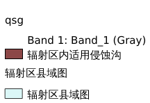
9.4. 三分场海伦辐射区沟毁耕地填埋修复技术适宜性评估图#
三分场海伦辐射区沟毁耕地填埋修复技术适宜性评估图
Legend:#

Information:#
Path : /pb1/gisws/qgis_pub_map/svr_w24/shenjl_rsync/ch04_heitu/sec08_agriclture/pub_HLfsq_mode2.qgz
Layer Name : pub_HLfsq_mode2_qn6259
Layer ID : qn6259
Center : 47.47504, 127.913246
Zoom : 6
Powered by GISLite and Sphinx.