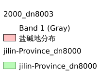
5.3. 吉林省2000年30m分辨率盐碱地分布情况#
吉林省2000年30m分辨率盐碱地分布情况
Legend:#

Information:#
Path : /pb1/gisws/qgis_pub_map/svr_w24/shenjl_rsync/bgs88_a5_out/ws_jl/ch03_jilin/sec05_lwj_saline-alkali-land_treatment/pub_jl_saline-alkali-land_dn8003.qgz
Layer Name : pub_2000_dn8003_qn3186
Layer ID : qn3186
Center : 43.287464, 126.84137
Zoom : 6
Powered by GISLite and Sphinx.