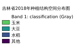
2.54. 吉林省2018年种植结构空间分布图#
黑土区吉林省2018年种植结构空间分布情况,包含玉米、大豆、水稻及其他
Legend:#
Information:#
Path : /pb1/gisws/qgis_pub_map/svr_w24/shenjl_rsync/bgs88_a5_out/ch03_jilin/sec02_sjl_02/pub_jl_plantingst.qgz
Layer Name : pub_jl_plantingst_2018_qn4627
Layer ID : qn4627
Center : 43.695084, 126.50227
Zoom : 6
Powered by GISLite and Sphinx.