10. 矢量空间分析(缓冲区)
|
目标: |
了解缓冲在矢量空间分析中的使用。 |
关键词: |
矢量、缓冲区、空间分析、缓冲区距离、融合边界、向外和向内缓冲区、多缓冲区 |
10.1. 概述
Spatial analysis 使用空间信息从地理信息系统数据中提取新的和附加的含义。通常使用地理信息系统应用程序进行空间分析。地理信息系统应用程序通常具有用于要素统计的空间分析工具(例如,这条折线由多少个折点组成?)或地理处理,如要素缓冲。所使用的空间分析类型因主题领域而异。从事水管理和研究(水文学)工作的人很可能会对分析地形和对水在其上移动时的模型感兴趣。在野生动物管理中,用户对处理野生动物点位置及其与环境的关系的分析功能感兴趣。在本主题中,我们将讨论缓冲,将其作为可对矢量数据执行的有用空间分析的示例。
10.2. 详细缓冲
Buffering 通常创建两个区域:一个区域是 within 与所选真实世界要素和其他区域之间的指定距离 beyond 。位于指定距离内的区域称为 buffer zone 。
A buffer zone is any area that serves the purpose of keeping real world features distant from one another. Buffer zones are often set up to protect the environment, protect residential and commercial zones from industrial accidents or natural disasters, or to prevent violence. Common types of buffer zones may be greenbelts between residential and commercial areas, border zones between countries (see 图 10.7), noise protection zones around airports, or pollution protection zones along rivers.
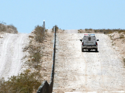
图 10.7 美利坚合众国和墨西哥之间的边界由缓冲区隔开。(吉姆·格林希尔中士2006年摄)。
In a GIS Application, buffer zones are always represented as vector polygons enclosing other polygon, line or point features (see 图 10.8, 图 10.9, 图 10.10).
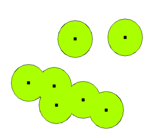
图 10.8 矢量点周围的缓冲区。
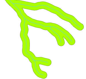
图 10.9 矢量多段线周围的缓冲区。
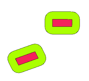
图 10.10 矢量多边形周围的缓冲区。
10.3. 缓冲中的变化
There are several variations in buffering. The buffer distance or buffer size can vary according to numerical values provided in the vector layer attribute table for each feature. The numerical values have to be defined in map units according to the Coordinate Reference System (CRS) used with the data. For example, the width of a buffer zone along the banks of a river can vary depending on the intensity of the adjacent land use. For intensive cultivation the buffer distance may be bigger than for organic farming (see Figure 图 10.11 and Table table_buffer_attributes).
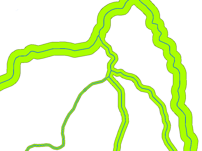
图 10.11 缓冲具有不同缓冲距离的河流。
河 |
毗邻土地利用 |
缓冲距离(米) |
|---|---|---|
布里德河 |
蔬菜精耕细作 |
100 |
科马蒂 |
棉花精耕细作 |
150 |
奥兰杰 |
有机农业 |
50 |
泰勒河 |
有机农业 |
50 |
表缓冲属性1:基于相邻土地利用信息的不同缓冲距离到河流的属性表。
多段线要素(例如河流或道路)周围的缓冲区不必位于线的两侧。它们可以位于线要素的左侧或右侧。在这些情况下,左侧或右侧由数字化过程中从直线起点到终点的方向确定。
10.3.1. 多个缓冲区
A feature can also have more than one buffer zone. A nuclear power plant may be buffered with distances of 10, 15, 25 and 30 km, thus forming multiple rings around the plant as part of an evacuation plan (see 图 10.12).
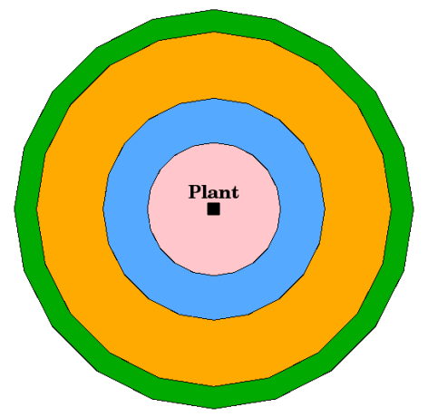
图 10.12 缓冲距离分别为10、15、25和30公里的点要素。
10.3.2. 具有完整或已溶解边界的缓冲
Buffer zones often have dissolved boundaries so that there are no overlapping areas between the buffer zones. In some cases though, it may also be useful for boundaries of buffer zones to remain intact, so that each buffer zone is a separate polygon and you can identify the overlapping areas (see Figure 图 10.13).
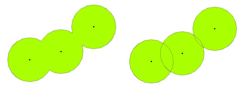
图 10.13 有溶解的缓冲区(左)和有完整边界的缓冲区(右)显示重叠区域。
10.3.3. 向外和向内缓冲
多边形要素周围的缓冲区通常从多边形边界向外延伸,但也可以从多边形边界向内创建缓冲区。例如,旅游部想要在罗本岛周围规划一条新路,环境法要求这条路从海岸线向内至少200米。他们可以使用向内的缓冲区来找到内陆200米长的线路,然后规划他们的道路不超过这条线路。
10.4. 需要注意的常见问题/事情
大多数GIS应用程序都将缓冲区创建作为一种分析工具,但创建缓冲区的选项可能会有所不同。例如,并非所有的GIS应用程序都允许您在线要素的左侧或右侧进行缓冲、融合缓冲区的边界或从多边形边界向内缓冲。
缓冲距离始终必须定义为整数(整数)或十进制数(浮点值)。根据矢量层的坐标参考系(CRS),以地图单位(米、英尺、十进制度)定义此值。
10.5. 更多空间分析工具
缓冲是一种重要的、经常使用的空间分析工具,但还有许多其他工具可以在地理信息系统中使用,供用户使用。
Spatial overlay is a process that allows you to identify the relationships between two polygon features that share all or part of the same area. The output vector layer is a combination of the input features information (see 图 10.14).
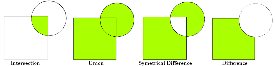
图 10.14 具有两个输入向量层的空间叠加(a_input=矩形,b_input=圆形)。生成的矢量层显示为绿色。
典型的空间覆盖示例包括:
Intersection :输出层包含两个层重叠(相交)的所有区域。
Union :输出层包含两个输入层合并后的所有区域。
Symmetrical difference :输出层包含输入层的所有区域,但两个层重叠(相交)的区域除外。
Difference :输出层包含第一个输入层中与第二个输入层不重叠(相交)的所有区域。
10.6. 我们学到了什么?
让我们总结一下我们在此工作表中介绍的内容:
Buffer zones 描述真实世界特征周围的区域。
缓冲区总是 vector polygons 。
一项功能可以具有 multiple 缓冲区。
缓冲区的大小由 buffer distance 。
缓冲距离必须是 integer 或 floating point 价值。
对于矢量图层中的每个要素,缓冲区距离可以不同。
可以对面进行缓冲 inward 或 outward 从多边形边界。
可以使用以下命令创建缓冲区 intact 或 dissolved 边界。
除了缓冲,地理信息系统通常还提供各种矢量分析工具来解决空间任务。
10.7. 现在你来试试吧!
以下是一些建议,可供您尝试与您的学习者:
Because of dramatic traffic increase, the town planners want to widen the main road and add a second lane. Create a buffer around the road to find properties that fall within the buffer zone (see 图 10.15).
为了控制抗议团体,警方希望设立一个中立区,让抗议者与一座建筑保持至少100米的距离。在建筑周围创建一个缓冲区,并给它上色,这样活动策划者就可以看到缓冲区的位置。
一家卡车工厂计划扩张。选址标准规定,潜在选址必须在重型道路1公里以内。沿着主干道建立一个缓冲区,这样你就可以看到潜在的地点在哪里。
想象一下,该市想要引入一项法律,规定任何瓶子商店不得位于学校或教堂1000米的缓冲区内。在你的学校周围建立一个1公里的缓冲区,然后去看看是否有离你的学校太近的瓶子商店。
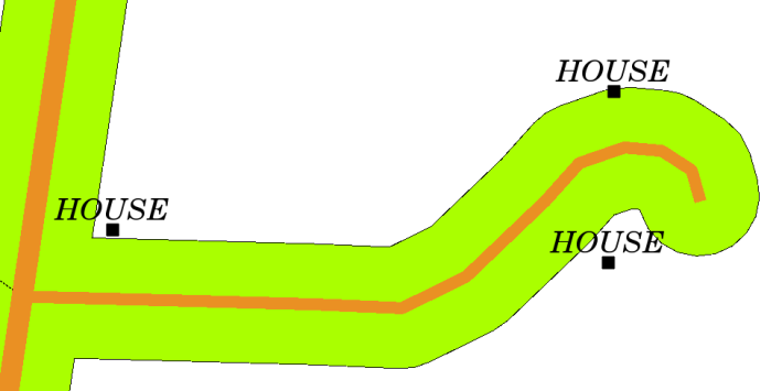
图 10.15 道路地图周围的缓冲区(绿色)(棕色)。你可以看到哪些房子落在缓冲区内,所以现在你可以联系房主,和他谈谈情况。
10.8. 一些值得思考的事情
如果你没有可用的电脑,你可以使用地形图和指南针在建筑物周围建立缓冲区。用指南针在你的地物上做一个等距离的小铅笔记号,然后用尺子把记号连起来!
10.9. 进一步阅读
Books :
史蒂芬·R·加拉蒂(2006)。地理信息系统揭开神秘面纱。Artech House Inc.ISBN:158053533X
张康宗(2006)。地理信息系统概论。第三版。麦格劳·希尔。ISBN:0070658986
迈克尔·N·德默斯(2005)。地理信息系统基础。第三版。威利。ISBN:9814126195
《QGIS用户指南》还提供了有关在QGIS中分析矢量数据的更详细信息。
10.10. 下一步是什么?
在接下来的部分中,我们将更仔细地了解 interpolation 作为空间分析的一个例子,您可以使用栅格数据。