遥感教程第15-4页
` <>` __
最后,给出了地理信息系统(有变种)的形式定义,并阐述了其主要短语。介绍了地理信息系统的历史和发展。给出了以地理信息系统作为问题解决和决策框架的规划过程。GIS框架内数据管理的交互组件也显示在流程图中。
地理信息系统定义
一种用于捕获、存储、检查、集成、操作、分析和显示空间上与地球相关的数据的系统。
更简单的工作定义是: A computer-based approach to interpreting maps and images and applying them to problem-solving. 包含计算机来存储、处理、操作、解释和显示地理信息系统信息是将现代地理信息系统与20世纪70年代以前使用地图和相关数据的更传统(传统)方法分开的关键因素。
` <>`__15-6: In their book on GIS, J. Star and J. Estes (see references at the end of this section) mention the four essential "M's" involved in the use of GIS by planners, resource managers, scientists, and others. These are operations that are commonly carried out in succession. Try to guess what these M's are. `ANSWER <Sect15_answers.html#15-6>`__
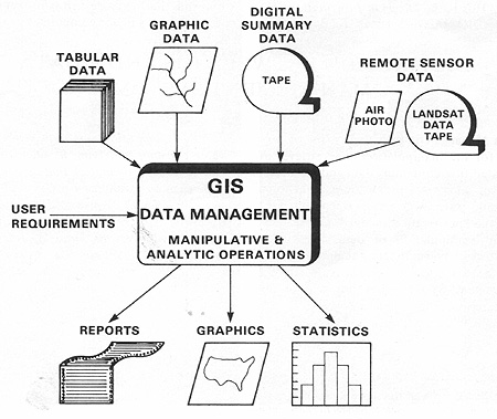
我们在此图中简要介绍了地理信息系统在选址、环境管理和其他地理相关应用的总体规划过程中的作用:
摘自B.Davis,gis:a visual approach,1996年。经美国新墨西哥州圣菲市Onword出版社许可转载。
` <>`__15-7: What is the "driver" or key determinant in the above Data Management diagram? `ANSWER <Sect15_answers.html#15-7>`__