遥感教程第8-1页
[Electromagnetic radiation at long wavelengths (0.1 to 30 centimeters) falls into a segment of the spectrum commonly called the microwave region. At still longer wavelengths (centimeters to meters) the radiation is known as radio waves (these can be generated by manmade transmitters or occur naturally [e.g., beamed from energetic stars]). Remote sensing has utilized passive microwaves, emanating from thermally activated bodies. But, in much more common use (since World War II) is another manmade device, radar, an active (transmitter-produced) microwave system that sends out radiation, some of which is reflected back to a receiver. The varying signal, which changes with the positions and shapes of target bodies, and is influenced by their properties, can be used to form kinds of images that superficially resemble those recorded by Landsat-like sensors. This first page introduces certain basic principles, described the common radar bands in use, and shows a typical radar image.]
雷达和微波遥感*
雷达定义
雷达 是无线电探测和测距的缩写。它工作在电磁频谱的微波区域的一部分,特别是在40000到300兆赫(MHz)的频率间隔内。后一个频率扩展到广播无线电区域的更高频率。通常使用的频率及其相应的波长由波段命名法规定,如下所示:
Ka波段:频率40000-26000兆赫;波长(0.8-1.1厘米)
K波段:26500-18500兆赫;(1.1-1.7厘米)
X波段:12500-8000兆赫;(2.4-3.8厘米)
C波段:8000-4000兆赫;(3.8-7.5厘米)
L波段:2000-1000兆赫;(15.0-30.0厘米)
P波段:1000-300兆赫;(30.0-100.0厘米)
与其他被动感应来自太阳或热源照射的目标的辐射的传感器不同,雷达通过发送从目标反射的脉冲或电磁能量脉冲来产生自己的光照(因此,它是活动的;另一个例子是闪光照相机)。然后,反射能量的一小部分返回雷达的接收天线,接收天线收集能量并将其传递给电子系统。因此,雷达系统是一种测距装置,它测量距离,作为定向脉冲束(信号强度以分贝(db)测量)在特定距离上传播的往返行程时间(光速)的函数。这样,雷达就可以确定从仪器(固定或移动)到能量散射物体的方向和距离。我们还可以通过分析信号的变化来获得目标形状和表面及其下方材料的某些诊断物理性质的信息。
` <>`__8-1 : In the Introduction, you learned that wavelength x frequency = the speed of light. By choosing the proper units, this equation can be derived: Wavelength (in cm) = 30/frequency (in GHz or 10:sup:`9`cycles per second. Given a frequency of 20 GHz, what Wave Band would this radar pulse fall into? `ANSWER <Sect8_answers.html#8-1>`__
通过提供自己的照明,雷达可以昼夜工作,并且对于某些波长而言,不受阻挡大气条件(如云)的明显干扰。这些特点促使雷达在第二次世界大战中用于跟踪飞机和船舶。地面(固定)和机载(移动)雷达系统今天广泛用于海上导航和空中交通管制。安装在空中或空间平台上的成像雷达在绘制云层覆盖的陆地表面(巴拿马地形图采用了这种方法)方面被证明特别有用。这种用法还允许在植被覆盖严重的区域(被一些带穿透)表达表面形状。
` <>`__8-2:Why did radar play such a vital role in the Allies' victory over Germany in World War II? `ANSWER <Sect8_answers.html#8-2>`__
这种反射地面以显示地形的能力是在移动平台上运行的雷达的主要用途。在我们展示的雷达图像带(航天飞机上的SIR-A系统)中,这一有用性得到了显著的证实,该雷达图像带向东北(右侧)延伸了300公里(200英里),横跨玻利维亚折叠和解剖的南美安第斯山脉。图像覆盖了从西部的高原(Altiplano)到东部的低地(亚马逊盆地)。(滚动查看右端。)
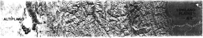
` <>`__8-3 : **Care to guess why the Low plains are dark and the High (Alti) plains are light.**
雷达系统,以及在微波波长(略短于雷达)下工作的无源传感器,在探测土壤湿度和海况方面也很有效。
` <>`__* This unit is adapted and expanded from the section on Radar Systems (pp. 367- 374) in the Landsat Tutorial Workbook, NASA RP 1078, 1982. For an excellent, up-to-date review of Imaging Radar Technology, covering both air and space systems, click on the NASA JPL Radar Page