摘要: OpenLayers 是一个专为Web GIS 客户端开发提供的JavaScript 类库包,用于实现标准格式发布的地图数据访问。从OpenLayers2.2版本以后,OpenLayers已经将所用到的Prototype.js组件整合到了自身当中,并不断在Pr...
OpenLayers 是一个专为Web GIS 客户端开发提供的JavaScript 类库包,用于实现标准格式发布的地图数据访问。从OpenLayers2.2版本以后,OpenLayers已经将所用到的Prototype.js组件整合到了自身当中,并不断在Prototype.js的基础上完善面向对象的开发,Rico用到地方不多,只是在OpenLayers.Popup.AnchoredBubble类中圆角化DIV。
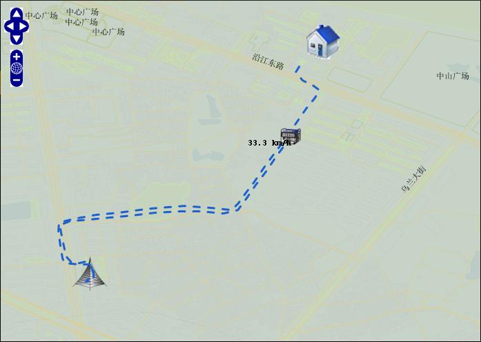
Openlayers中通过很多方式都能实现实时监控。
实现实时监控:如:页面发起异步请求;服务端程序将请求结果处理成GeoJSON串回传至请求页面;请求页面通过OpenLayers提供的OpenLayers.Format.GeoJSON解析GeoJSON串,将结果展现到地图上。
下面的示例显示:实时获得油机的位置数据,展示到页面上。
页面程序:
//初始地图
function init(){
......
vectors = new OpenLayers.Layer.Vector(...);
geojson = new OpenLayers.Format.GeoJSON();
map.addLayer(vectors);
}
//通过DWR异步取得GeoJSon串,交由OpenLayers.Format.GeoJSON来处理.
function locorie(){
//异步发出请求
dwrService.orie(orieSeri,function(data){
//通过OpenLayers.Format.GeoJSON处理服务端提供的GenJSon串
var features = geojson.read(data,"FeatureCollection");
if(features) {
//将结果展示到地图上
vectors.addFeatures(features);
}
});
}
//十秒更新一次数据
function startOrie(){
var t=setTimeout("locorie();startOrie();",10000);
}
服务端程序:
public String[] orie(String orieSeri) {
String orieStr = "";
boolean state = true;
if (null == orieStr || "".equals(orieSeri)) {
state = false;
}
int dataSeri = Integer.parseInt(orieSeri);
List list = null;
if (state) {
// 获得dataSeri之后的位置数据 Location.getDataSeri >= dataSeri
list = locDao.findLocByFlow(dataSeri);
}
if (state && (list == null || list.size() == 0)) {
// 没有数据
state = false;
}
if (state&&(list.size() == 1 && dataSeri == list.get(0).getDataSeri()
.intValue())) {
// 没有新的数据
state = false;
}

if (state) {
LineString line = new LineString();
StringBuffer geo = new StringBuffer();
Point pointEnd = new Point();
Feature feaPoint = new Feature(pointEnd);
Map propoint = new HashMap();
feaPoint.setProperties(propoint);
for (int i = 0; i < list.size(); i++) {
geo.append("[" + list.get(i).getCurLoc() + "]");
if (i != (list.size() - 1)) {
geo.append(",");
}
}
line.setLine(geo.toString());
Feature feaLine = new Feature(line);
Map properties = new HashMap();
properties.put("color", "#1A60CA");
feaLine.setProperties(properties);
List components = new ArrayList();
components.add(feaLine);
components.add(feaPoint);
FeatureCollection feaCol = new FeatureCollection(components);
orieStr = feaCol.draw();
}
}
服务器端提供的数据格式如下:
//一条线
{
"type":"FeatureCollection",
"features":[{
"type":"Feature",
"geometry":{
"type":"LineString",
"coordinates":[[42.895131111145, 22.148587703705],[43.895131111145, 23.148587703705]]}}]
}
服务器端生成json串,用装饰者模式写了一个模块,只要调用这个模块的API就会生成需要的Json串。