OverviewActivity
“熟悉”活动
正如在前一个概述页面上宣布的那样,在本教程的后面将有几个测试(“考试”)来测试您对所学信息的了解以及到那时为止所掌握的技能。但是,首先,我们要求你现在进行一个简单的“考试”,我们委婉地称之为“活动”,旨在帮助你通过经验或常识(直觉)来确定你已经知道的关于识别几种空间图像中的特征,然后分析或解释。它们基于你对日常世界的了解。
方法很简单:我们将集中在北美的一个地区,向您展示各种各样的图像。您将得到一系列与这些相关的问题。有些你应该能够马上回答;有些你可能不确定或者只是不知道。但是,正如您在概述页面中看到的那样,对于您可以点击的每一个问题,都会有答案,并且在默认情况下,这样做是为了学习。下面是:
我们首先向您展示北美洲部分的低分辨率,该部分包含待研究区域。这个场景是由轨道成像公司运营的一颗卫星orbview2拍摄的。
` <>`__Ex-1: Where are you" Name at least 4 states that are in the scene. There is a lake that you have seen before in the Overview. Name it. Take a wild guess as to why its upper half is purple.`ANSWER <the-abswers2.html#Ex-1>`__
既然您的方向是地理上的,那么下一幅图像将归零到包含处于我们将关注的状态的区域的状态。这一场景是由Terra卫星上的modis传感器拍摄的(见第16节)。
` <>`__Ex-2: What is the State. Consult an Atlas, if need be, and see what major geographic features you can name.`ANSWER <the-abswers2.html#Ex-2>`__
现在,我们将重点放在更直接的研究区域。这是一张Landsat-7自然色主题映射器(TM)图像:
下面的图片也是这一场景的TM图像,但拍摄时间不同。

` <>`__Ex-3: Locate what appear to be major metropolitan areas. What colors define these? What is the body of water that lies inland from the ocean? Why are there different bluish tones in the ocean and brownish in the inland extension? What is likely to be causing the dense green areas in parts of the images? In the upper right of both is an area that you have already encountered as the Great Valley. What are the square to rectangular patterns seen in this Valley? Why are many of these patterns brown in the upper and green in the lower image?`ANSWER <the-abswers2.html#Ex-3>`__
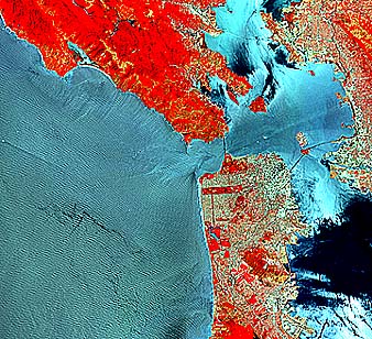
虽然自然色图像把我们联系得更接近地球出现的方式,如果我们是在宇宙飞船的飞机上,一个非常常见的颜色再现(已经看到的盐湖城图像)往往是红色作为主导颜色。考虑一下这个位于加利福尼亚州中西部(当地人称之为北部)的海湾地区的陆地卫星1图像。
旧金山和周边地区的假彩色Landsat 1场景。
` <>`__Ex-4: Unless you have had previous experience with this type of rendition, known as false color, the reason for the red is probably not in your knowledge bank. Take a guess as to why. Why is the ocean black? What color dominates the cities? There are several mountain chains in the image. One is dominated by red because of forestation. Another shows much fewer trees. How do you recognize this chain? Finally, the natural color Landsat full scene has a resolution of 30 m and this false color scene has a 79 m resolution; why do the details (sharpness of features) appear about the same in spite of the resolution differences? `ANSWER <the-abswers2.html#Ex-4>`__
暂时停留在假彩色主题上,下一张图片是由SPOT卫星拍摄的(见第3节),其分辨率为20米。
` <>`__Ex-5: Somewhat more detail is seen in San Francisco in this SPOT scene. Compared with the previous Landsat scenes, at 30 and 79 meter resolution, this scene helps one to locate a particular feature associated with roads. Try to find it.`ANSWER <the-abswers2.html#Ex-5>`__
下一对子场景是陆地卫星7图像的进一步放大。检查它们,在你的地图册的帮助下,回答下面的问题。
` <>`__Ex-6: Find Mount Diablo in the upper scene. Two areas east of the East Bay Coast Range are marked by a concentration of patterns typical of urban areas. They lie along U.S. Highway 50. Identify them.The writer (NMS) worked in the town further east at the Lawrence Radiation Laboratory. When I did, neither town was anywhere close to their present size. In the upper image, make a guess as to what are the patterns of green and brown in the lower San Francisco Bay north of San Jose. About what time of year was this image acquired; give reasoning. In the lower image, why are the two S.F. bridges now visible, even though this is 30 m resolution imagery.`ANSWER <the-abswers2.html#Ex-6>`__
这是一张宇航员从航天飞机拍摄下来的照片,他俯瞰着旧金山北部。
旧金山航天员假彩色照片
` <>`__Ex-7: Comment on the details evident in this photograph. Make a guess about the scene resolution.`ANSWER <the-abswers2.html#Ex-7>`__
下面是一张中等比例尺的航空照片(从几英里以上的飞机上拍摄;分辨率为几米)。试着找出它在宇航员照片中的位置(在下面的Ex-8中回答)。
旧金山航空摄影覆盖部分。
下一个是这个 非凡的 这张照片的分辨率非常高(1米以上),即使是由伊科诺斯卫星(空间成像公司)在400多英里的轨道高度拍摄的。注意一些单独的建筑物。
旧金山的IKONOS影像
为了帮助你找到这个场景,考虑一下旧金山东侧的地面照片,摄于美国东北部的科伊特塔。
旧金山市中心的天际线。
` <>`__Ex-8: What part of San Francisco is shown on the right side of the aerial photo? Try to fit the IKONOS image into this photo. There is a prominent building in the IKONOS image and in the ground view that is absent in the aerial photo. Find it - perhaps you know its name. What does this tell you about the "age" of the aerial photo? In the IKONOS image the buildings seem to be leaning somewhat. What does that mean in terms of the conditions in which the IKONOS satellite was "looking" at its target?`ANSWER <the-abswers2.html#Ex-8>`__
到目前为止,我们所看到的图像和照片是由可见光范围内的电磁辐射构成的,在一些情况下,包括来自近红外的辐射。其他波长的辐射可以被感知并用来形成图像。频谱的这些部分包括紫外线、热红外、被动微波和主动微波(雷达)。您可能不熟悉这些图像的外观,但是接下来的几个图像将介绍给您它们的外观。例如,这一个是白天由安装在飞机上的传感器制造的:
旧金山。
在另一个极端,看看这个由HCMM卫星在夜间拍摄的图像,它覆盖了加利福尼亚州中西部的大部分地区。在阅读下一个问题之前,先猜猜这两个图像属于哪种类型(就上一段中列出的四种图像而言)(然后,进入第9节,全面回顾这种遥感模式)。
` <>`__Ex-9: This is a "giveaway" as to identifying the type of image: Light tones indicate relative "warm" and dark tones denote relative "cold". In the daytime thermal image, try to match several of the very dark patterns to specific features (again, use an atlas to help pick out known localities). Why is much of the City in light tones? In the lower image, first find the San Francisco Bay. Why is the Bay water lighter in tone than the surrounding land? What are the wispish lighter tones in the Pacific Ocean? What is the very dark area in the upper right? How does the central part of the Great (Sacramento) Valley appear? Account for the bright tones along the sides of the Valley?`ANSWER <the-abswers2.html#Ex-9>`__
现在到最后一张图片,我们将考虑(稍后,见第8节)。看看这两个问题,然后回答这个问题。
旧金山、旧金山
` <>`__Ex-10: What type of image are these two? How do the mountains appear in the left scene? (This is usually a "trademark" of this class of image.) In that scene, what do at least some of the very bright patches correspond to? Given that images produced by this sensor type can be multiband (several wavelengths) and multipolarized, speculate on how the right image is displayed in color.`ANSWER <the-abswers2.html#Ex-10>`__
有一个非常常见的表面特征,由于普遍存在的草和树木覆盖,在北加利福尼亚州的空间图像中没有很好地表达出来。这是对潜在地质的揭示。通常,地质岩石单元最有可能暴露在干旱到半干旱的地形中并直接可见,这在美国西部的大部分沙漠地区很常见。这在第2节中有详细介绍。现在,我们只想让你(毫无疑问)从陆地卫星图像中看到暴露在外的地质单元有多强烈。我们从第2节中提取了两个场景。第一个图显示了从空中看的部分水袋单斜褶皱(地层向一个方向倾斜)。第二种是陆地卫星假彩色合成图,其面积与图片中的几乎相同。看看你是否能把照片中的几个单位和它们在图像中的等价物相匹配。
好吧,给你。你对这10个问题做得怎么样?即使你在获得正确的(最好的)答案时遇到了一些困难,只要简单地尝试然后检查答案,你就会学到许多遥感和图像解释的基本思想和原则。因此,从下一步的介绍开始,您可以很好地进入本教程的其余部分。