遥感教程第14-14页
目录
Sea ice is both an oceanographic and a meteorological feature. Satellites are almost the only convenient way to monitor ice accumulations in the polar regions. Satellites with high resolution sensors can also detect icebergs. Generally, any spectral band in the visible is suited to spotting ice but thermal imagery and radar (especially at night) also will find it. Some examples of what can be seen from space substantiate the utility of satellites for picking out ice distribution - of vital concern to those who must travel in shipping lanes where passage may be impossible or where dangers lurk. (The big "what might have been" question: could satellite observations have saved the Titanic?)
海冰监测
|大西洋南部南极威德尔海冰的多波段彩色合成SIR-C图像。|
` <>`__14-36 : 为什么冰块呈现块状或拼凑状? **ANSWER**
夏季海冰可能会消退,但随着冬季的到来,新的模式会发生变化,如格陵兰海岸外的陆地卫星图像所示:
` <>`__14-37 : 冰漩涡是朝哪个方向旋转的? **ANSWER**
现在,陆地上的modis传感器有效地监测了大区域的海冰分布(见第16节)。这里可以看到冰穿过并阻塞西伯利亚和阿拉斯加西部之间的白令海峡。
北半球的极地区域被海冰、冰盖或冰盖(如格陵兰岛)和雪覆盖,如由Radarsat SAR图像构建的合成图像所示:
接下来,我们展示了在本节前面出现的ESMR所感知到的南极洲周围冰原的生长和收缩。下面这些图像是SMRR图像,在顶部的图表中显示了1978-86年间4年的冰盖变化。
` <>`__14-38 : In the lower of these two diagrams above, why is ice minimal in December? In the upper diagram, what is ice-covered besides the Arctic Ocean? **ANSWER**
南极大陆周围的冰架有时从海岸延伸100公里。它的部分边缘会周期性地松动,在南大洋自由浮动。1995年,一个大的(比罗德岛大)冰筏,分配了标识B10,分离并开始向北移动。后来又分成两部分。小碎片像冰山一样继续崩解。这是一张B10A的陆地卫星图像,显示了这张纸及其子代的Bergs:
2002年初,位于贝林斯高森海和温德尔海之间的拉森冰架上的另一大块冰破裂,现在正在南极洲海域巡航。这是这个破裂阶段的一个场景,由2002年2月发射的envisat(见概述)上的ASAR雷达拍摄。
虽然由于自然/人为引起的全球变暖,海冰(和冰盖)覆盖的面积和厚度的一些变化可能正在向较低的总面积发展,但也存在正常的季节性波动。以下是2002年6月至7月期间北极海冰和南极大陆架冰的Aqua(第16-11页)上的AMSR-E传感器拍摄的两组图像:

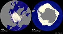
在北半球,随着夏季的发展,冰会逐渐缩小。但是在南半球,每年这个时候都是冬天,南极周围的冰架在增加。