遥感教程第14-7页
目录
The various geostationary satellites from several countries, either now functioning or having become non-operating, provide synoptic views of about one-fourth of the Earth�s surface. The part (it remains the same) they cover depends on where they are located relative to a point along (close to) the equator. By completing their orbit once every 24 hrs, they stay fixed relative to Earth�s equatorial rotation and thus are "stationary" in space. This page concentrates on the U.S.�s GOES series but similar satellites from other nations� space programs are discussed. Thus, in today�s world, mankind has an excellent network of satellites monitoring the Earth�s weather systems.
地球同步卫星
` <>`__14-16 : Comment on at least one mega-weather pattern in the northern and in the southern hemispheres as time progresses from January 2 through the 7th. **ANSWER**
` <>`__14-17: Is that a hurricane at about 1:00 o'clock in the hemisphere, off the Spanish coast? **ANSWER** ****
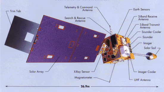
GOS-1于1975年10月16日发射后不久,以135°W的温度抵达地球静止轨道。其他发射间隔2到3年(巧合的是,GoS-10于1997年4月25日进入轨道,作者在同一天写下了这段文字)。我们指的是覆盖大西洋和美国东部向东(位于赤道上方经度75°W处)的卫星,以及太平洋上空向西(经度135°W处)的卫星。它们一起提供了大西洋和太平洋的覆盖范围,如图所示,该图还说明了视图的全磁盘性质:
要覆盖整个地球,需要四次。然而,世界上的其他地方都是由其他系统监控的(见下页)。从2000年年中开始,GOES-8和GOES-10都在运行,GOES-9和GOES-11也在轨道上,但在前两个中的一个或两个失效之前都在储存中。
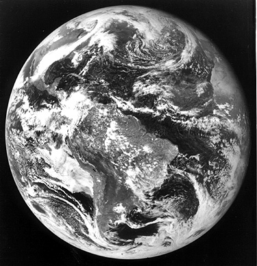
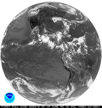
同样,vissr是主要的传感器,但探测(vas是vissr大气发声器)能力也在船上。从GOES-8(1994年4月13日)开始,vissr一直在运行,而不是提供定期视图。为了举例说明GOES图像,我们现在展示1975年10月26日GOES-1的第一张可见图像(顶部)和1995年6月19日GOES-9的第一张测试红外图像(底部):
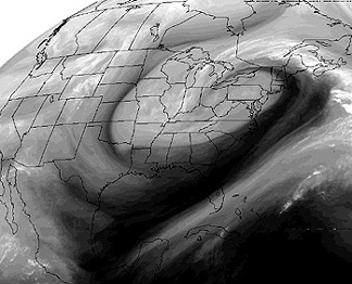
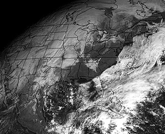
` <>`__14-18 : The March 20th storm shown in the upper of the two images just above resulted in a huge snowfall over its northern segment. The cloud pattern resembles a hurricane but there are differences. Mention several of these.` <Sect14_answers.html#14-18>`__ **ANSWER**
不寻常的色彩合成可以从不同的渠道图像。顶部(或左侧)是GOES-8 6.7微米通道图像的彩色再现,它对水蒸气分布很敏感,突出了1994年3月20日的美国大风暴。底部(或右侧)是由通道6.7微米=蓝色;11微米=绿色;可见=红色制成的假彩色图像。这张图片显示了雨果飓风,如1989年9月21日所见。
主要作者:Nicholas M.Short,高级电子邮件: nmshort@nationi.net