克里米亚历史公报
Every day, Ottomanists around the world generate valuable materials as components of their scholarly research, but these materials may not be readily available to scholars with similar interests. The purpose of the OpenOttoman (Amy Singer, OpenOttoman: A Collaborative Platform for Digital Scholarship, https://networks.hnet.org/node/11419/discussions/166360/openottoman-collaborative-platform-digital-scholarship, 2017) is to stimulate generation of such materials and provide open and convenient access to these materials. The OpenOttoman Portal (http:// www.openottoman.org) (OOP) is one vehicle for accessing these materials. Materials made available through the OOP include databases, with a prime example being gazetteers of Ottoman world places. Here, we describe the Historical Gazetteer of the Crimea (HGC), a prototype OOP gazetteer that includes populated places, districts, and provinces of Crimea in existence at the end of the Crimean Khanate.
HGC数据库的主要数据来源是Jankowski的《克里米亚前俄罗斯地区词典》(Henryk Jankowski,《克里米亚前俄罗斯居住区名称的历史语源词典》,Brill,Leiden,2006年)。此源包含一张地图,显示137个人口稠密的地方的位置,其中99个与地名数据库中包含的现有地方相关联。这些是hgc中填充的place条目,这些条目的纬度和经度来自geonames数据库。
Jankowski的地图还显示了6个省和43个区的边界。这些特征的hgc位置是使用Jankowski地图上显示的边界近似的区域质心。HGC包含Jankowski地图上显示的16条河流中的14条,以及61条附加河流,以帮助确定人口密集地区和地区和省边界。
Terrain elevation data (Shuttle Radar Topography Mission (SRTM) data, available at https://lta.cr.usgs.gov/SRTM1Arc) was incorporated into a base map of the region covered by Jankowski’s map. District and province boundaries were approximated using Jankowski’s map plus terrain features such as rivers, ridge lines, and valleys where boundaries on Jankowski’ map were difficult to trace. Gazetteer locations for rivers are river mouth latitude and longitude taken from the GeoNames database. Per Table 1, the HGC includes three separate sets of databases which can be accessed at http://epublications.marquette.edu/ottoman_crimea/. This website also provides access to a project named HGC-QGIS-Project.qgs. Opening the project in QGIS yields the result shown in Figure 1. For the KML and shape file rivers databases, rivers were traced in QGIS using the Google Maps physical map.
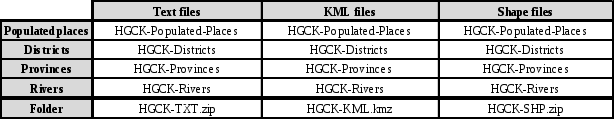
表1:公报数据库
在qgis中打开项目会得到如图1所示的结果。对于kml和shape文件rivers数据库,使用谷歌地图物理地图在qgis中跟踪河流。
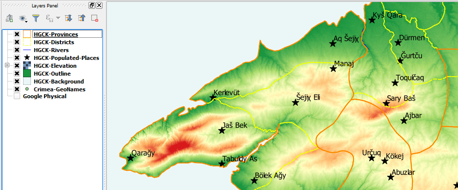
图1:hgc-qgis-project.qgs在qgis中打开。
表2显示了hgc数据库字段。请注意为数据库中的每个位置分配唯一ID的方式。由于每个Jankowski地点都与地名数据库中的一个地点相关联,并且地名数据库中的每个地点都有一个作为URL提供的唯一ID,因此该地点的地名URL将作为HGC地点的唯一标识符。
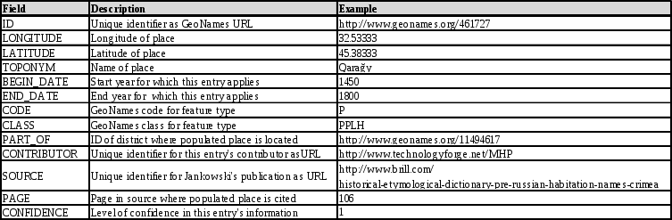
表2:HGC数据库字段。
请注意,ID可以在Web浏览器中打开,从而自动显示地名地图,其中填充的位置位于其中心,如图2所示。
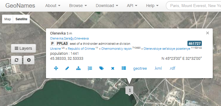
图2:在Web浏览器中打开qara_y的URL ID。
根据表2,地区、省和河流数据库的字段与人口稠密地区的字段相同,只是页面字段留空,因为地区、省和河流在Jankowski的字典中不显示为条目。地区、省份和河流的URL ID分配方式与它们分配给人口密集地区的方式相同。因此,在表2中,人口密集地区qara_y的字段部分是该地区所在地区tar_an的地名URL。代码和类字段使用地名数据库中使用的术语。根据示例,P代码一般适用于人口稠密的地方,而PPLH类(子代码)适用于不再存在的历史人口稠密的地方。
置信字段反映在特定数据库条目中捕获的数据的置信水平。由于HGC中的所有填充位置都可以与地名数据库中的现有位置相关联,因此它们被指定为1的置信级别。河流也被指定为1级的置信水平,因为它们是直接从谷歌地图追踪到的。
While providing a useful gazetteer, a primary purpose of the HGC was to serve as a test bed and use case for how other Ottoman world gazetteers could be incorporated into the OOP. Based on experience gained through this project, a new project has been initiated to geolocate approximately 3,000 populated places, rivers, river fords, rapids, islands, forests, mountains, and valleys found on a set of 17th century maps of Ukraine produced by Guillaume Le Vasseur, sieur de Beauplan. This project directly supports one of the principal investigator’s research on the Polish-Lithuanian Commonwealth /Ottoman Empire frontier. More generally, this work responds to the need for gazetteers of the Ottoman world as expressed by the OpenOttoman initiative (http://openottoman.org).
作者
图3:Michael和Mark Polczynski
迈克尔和马克·波尔钦斯基
Michael Polczynski(michael.polczynski@georgetown.edu)在乔治敦大学演讲,他的工作重点是早期现代奥斯曼帝国和东欧/中欧历史、边疆历史、历史地理、外交和知识史。迈克尔还研究了中世纪晚期的欧亚历史和19世纪奥斯曼帝国的欧洲移民,并广泛使用历史地理信息系统,管理多个在线学术团体。
Mark Polczynski(mark.polczynski@marquette.edu)从马奎特大学工程学院退休,目前为OpenOttoman(openOttoman.org)提供技术援助,OpenOttoman是一家专注于奥斯曼世界的跨国学术和公共历史数字协作机构。