


覆盖率分析器
- 作者
杰罗姆·布伊
NAME
mapcache_detail -mapcache sqlite缓存的覆盖率分析
SYNOPSIS
mapcache_detail [ options ]
DESCRIPTION
mapcache_detail 主要用例是希望离线使用覆盖给定地理区域的mapcache缓存的一部分的用户。为此,他们需要从现有缓存中标识相关文件,检查这些文件中是否缺少磁贴(如有必要,可能会播种丢失的部分),并提取这些文件以构建所请求区域的新缓存。
mapcache_detail ,帮助用户完成其中一些活动。它与sqlite缓存一起工作,其中一个文件可能包含数千个图块。它能够:
确定需要缓存中的哪些 SQLite 文件覆盖给定缩放级别范围内的给定地理区域;
计算覆盖区域所需的切片数量以及每个文件中已经存在的切片数量,给出文件级别、缩放级别和全局级别的覆盖率;
估计丢失的图块的数据大小,这些图块需要下载以完全覆盖请求的区域,再次覆盖文件级别、缩放级别和全局级别。
mapcache_detail 能够处理mapcache本身处理的所有类型的sqlite缓存,即:
Single SQLite caches ,其中只有一个sqlite数据库包含整个缓存;
Multiple SQLite caches ,其中缓存根据给定的模板拆分为多个sqlite数据库;
Composite SQLite caches ,它是单个和多个sqlite缓存的组合,具体取决于缩放级别。
mapcache_detail 采用使用mapcache库的独立CLI可执行文件的形式。建议将其作为对MapCache项目的简单贡献 contrib/mapcache_detail/ 文件夹,由于其特定用途(仅处理sqlite缓存)。
OPTIONS
有些选项的语法和含义与 mapcache_seeder utility .
杂项设置
- -h, --help
显示帮助消息并退出。
- -o, --short-output
(可选)如果存在此选项,则只报告现有的sqlite文件,对于级别和全局覆盖率,仍会考虑缺少的sqlite文件。
用于指定要分析的缓存的选项
- -c, --config mapcache配置文件
(必需)设置指定要分析的缓存的mapcache配置文件。
- -t, --tileset 小菜名
(必需)设置要分析的tileset。
- -g, --grid 网格名称
(必需)设置要分析的网格。
- -D, --dimension DIMENSION_NAME=VALUE
(可选)设置维度的值。此选项可多次用于多个维度。
- -q, --query <值>
(可选)设置SQL查询以计算矩形中的平铺数。下面给出的默认值与SQLite缓存的默认模式一起使用。
SELECT count(rowid)
  FROM tiles
 WHERE (x between :minx and :maxx)
   AND (y between :miny and :maxy)
   AND (z=:z)
   AND tileset=:tileset AND grid=:grid AND dim=:dim;
用于指定要覆盖的区域的选项
- -z, --zoom [最小缩放[,最大缩放]]
(可选)设置要分析的最小和最大缩放级别,用逗号分隔,例如:12、15。如果 最大缩放 不存在,仅由指定的缩放级别 微型变焦镜头 进行了分析。默认值为 0 .
矩形区域
- -e, --extent minx,miny,maxx,maxy
(可选)设置要分析的范围。默认值是整个网格范围。此选项不能用于 --ogr-datasource 选择权。
多边形区域
- -d, --ogr-datasource OGR数据源
(可选)设置要从中获取功能的OGR数据源。任何 OGR Vector Format 可以使用。如果不存在,则使用 --extent 选项,可能是其默认值。此选项不能用于 -范围 选择权。
- -l, --ogr-layer 图层
(可选)选择OGR数据源内的层。此选项仅在以下情况下有效 --ogr-datasource 已指定。此选项不能用于 –ogr-sql 选择权。
- -w, --ogr-where filter
(可选)设置要应用于OGR图层功能的过滤器。此选项仅在以下情况下有效 --ogr-datasource 已指定。此选项不能用于 –ogr-sql 选项。
- -s, --ogr-sql SQL 查询
(可选)用于筛选OGR数据源内部的SQL查询。此选项仅在以下情况下有效 --ogr-datasource 已指定。此选项不能用于 –ogr-layer或–ogr-where 。
计数切片
为了说明这个过程,这里有一个虚构的网格示例。瓷砖由网格上最小的正方形表示。每个25块的大正方形表示SQLite文件。小索引表示平铺坐标,而大索引表示数据库坐标。彩色矩形表示请求的缓存提取区域。较暗的平铺表示缓存中存在的平铺。
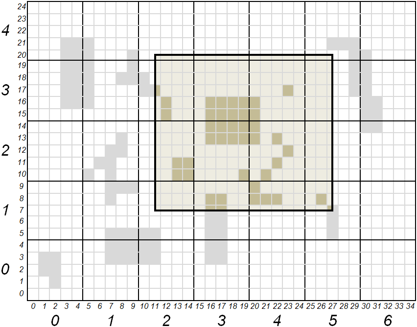
以切片、区域坐标表示 (xmin、ymin、xmax、ymax) 是(11,7,27,20)。用sqlite文件表示,这些坐标是(2,1,5,4)。包含坐标在(2,1)和(5,4)之间的所有文件应是缓存提取的一部分。坐标在(11,7)和(27,20)之间的所有切片应计入区域覆盖范围。
下表根据工具的流程给出了所请求区域的图块计数和覆盖率:
SQLite文件 |
(2,1) |
(2,2) |
(2,3) |
(2,4) |
(3,1) |
(3,2) |
(3,3) |
(3、4) |
(4,1) |
(4,2) |
(4,3) |
(4,4) |
(5,1) |
(5,2) |
(5,3) |
(5、4) |
合计 |
|---|---|---|---|---|---|---|---|---|---|---|---|---|---|---|---|---|---|
缓存和覆盖区域中存在的磁贴 |
0 |
4 |
3 |
0 |
4 |
9 |
8 |
0 |
4 |
6 |
3 |
0 |
2 |
0 |
0 |
0 |
43 |
完全覆盖区域所需的切片 |
12 |
20 |
20 |
4 |
15 |
25 |
25 |
5 |
15 |
25 |
25 |
5 |
9 |
15 |
15 |
3 |
238 |
新闻报道 |
0 |
0.2 |
0.15 |
0 |
0.267 |
0.36 |
0.32 |
0 |
0.267 |
0.24 |
0.12 |
0 |
0.222 |
0 |
0 |
0 |
0.181 |
输出报告
该工具的输出采用JSON格式,为用户提供要从缓存中提取的sqlite文件列表。详细说明了有助于区域覆盖的切片数量。还为每个缩放级别和全局级别提供了合成。
下面是一个虚构的例子,描述了工具输出中存在的信息。
{                                   _______________________________________
    "layer": "example",            | Report starts with general information
    "grid": "local",               | on cache and requested region
    "unit": "m",
    "region": {
        "bounding_box": [ 11, 7, 27, 20 ],
        "geometry": {
            "type": "Polygon",
            "coordinates": [[ [11,7], [11,20], [27,20], [27,7], [11,7] ]]
        }
    },
    "zoom-levels": [ {
            "level": 1,
            "files": [ {            _______________________________________
                                   | For each file, output report gives:
                                   | its name, its size, its bounding box
                                   | and intersection of that bounding box
                                   | with requested region

                "file_name": "/path/to/cache/example/1/2-1.sqlite",
                "file_size": 54632,
                "file_bounding_box": [ 10, 5, 14, 9 ],
                "region_in_file": {
                    "bounding_box": [ 11, 7, 14, 9 ],
                    "geometry": {
                        "type": "Polygon",
                        "coordinates":
                            [[ [11,7], [11,9], [14,9], [14,7], [11,7] ]]
                    }
                },
                "nb_tiles_in_region": { ___________________________________
                                   | Measures associated to a SQLite file
                                   | are: number of tiles belonging to
                                   | requested region and present in file,
                                   | number of tiles belonging to region
                                   | present or not in file, and resulting
                                   | coverage ratio

                    "cached_in_file": 0,
                    "max_in_file": 12,
                    "coverage": 0
                }
            }, {
                "file_name": ...
                ...
            } ],
            "nb_tiles_in_region": { _______________________________________
                                   | Measures associated to a zoom level
                                   | are the sum of the ones for each SQLite
                                   | file of that level

                "cached_in_level": 43,
                "max_in_level": 238,
                "coverage": 0.1807
            }
    }, {
            "level": 2,
            ...
    } ],
    "nb_tiles_in_region": {         _______________________________________
        "cached_in_cache": 43,     | Global measures are the sum of all
        "max_in_cache": 238,       | zoom level measures
        "coverage": 0.1807
    },
    "sizes": {                      _______________________________________
                                   | At global level estimations about
                                   | cache size to be extracted for a full
                                   | region coverage are also given. These
                                   | estimations are based on the mean size
                                   | of a tile obtained from all SQLite file
                                   | sizes and how many tiles they contain

        "total_size_of_files": 1599442,
        "total_nb_tiles_in_files": 60,
        "average_tile_size": 26658,
        "estimated_max_cache_size": 6344604,
        "estimated_cached_cache_size": 1146294,
        "estimated_missing_cache_size": 5198310
    }
}
EXAMPLES
分析tileset的切片覆盖率 osm 与 g 网格。默认范围是整个世界,默认缩放级别为0:
mapcache_detail --config mapcache.xml --tileset osm --grid g
与之前相同,显式缩放级别为9到12,显式范围覆盖瑞士:
mapcache_detail --config mapcache.xml --tileset osm --grid g --zoom 9,12 --extent 663000,5751230,1167680,6075050