

mapscript.mapObj
- class mapscript.mapObj(*args)
概述
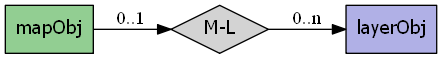
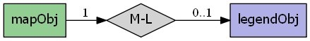
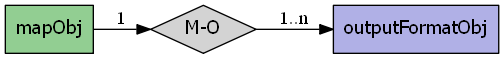
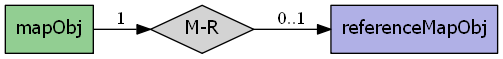
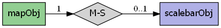
MapObj具有以下关系:
属性
cellsizeTODO 添加文档
configoptionsTODO 添加文档
datapatternTODO 添加文档
debugTODO 添加文档
defresolutionTODO 添加文档
extentTODO 添加文档
fontsetTODO 添加文档
heightimagecolorTODO 添加文档
imagequalityTODO 添加文档
imagetypeTODO 添加文档
interlaceTODO 添加文档
labelcacheTODO 添加文档
layerorderTODO 添加文档
legendTODO 添加文档
mappathTODO 添加文档
maxlayersTODO 添加文档
maxsizeTODO 添加文档
nameTODO 添加文档
numlayersTODO 添加文档
numoutputformatsTODO 添加文档
outputformatTODO 添加文档
querymapTODO 添加文档
refcountTODO 添加文档
referenceTODO 添加文档
resolutionTODO 添加文档
scalebarTODO 添加文档
scaledenomTODO 添加文档
shapepathTODO 添加文档
sldurlTODO 添加文档
statusTODO 添加文档
symbolsetTODO 添加文档
templatepatternTODO 添加文档
thisown会员旗
transparentTODO 添加文档
unitsTODO 添加文档
webTODO 添加文档
width方法
- OWSDispatch(req: mapscript.OWSRequest) int[源代码]
- appendOutputFormat(format: mapscript.outputFormatObj) int[源代码]
- applySubstitutions(mapObj self, char ** names)[源代码]
姓名:Char**
传入运行时替代键和值,并将它们应用于映射。
Note 此方法当前仅对Python启用。其他MapScript语言也需要类型地图。
- clone() mapscript.mapObj[源代码]
- draw() mapscript.imageObj[源代码]
- drawLabelCache(image: mapscript.imageObj) int[源代码]
- drawLegend() mapscript.imageObj[源代码]
- drawQuery() mapscript.imageObj[源代码]
- drawReferenceMap() mapscript.imageObj[源代码]
- drawScalebar() mapscript.imageObj[源代码]
- embedLegend(image: mapscript.imageObj) int[源代码]
- embedScalebar(image: mapscript.imageObj) int[源代码]
- getOutputFormat(i: int) mapscript.outputFormatObj[源代码]
- getOutputFormatByName(name: char) outputFormatObj[源代码]
- prepareImage() mapscript.imageObj[源代码]
- queryByRect(rect: mapscript.rectObj) int[源代码]
- queryByShape(shape: mapscript.shapeObj) int[源代码]
- removeLayer(index: int) mapscript.layerObj[源代码]
- setCenter(center: mapscript.pointObj) int[源代码]
- setOutputFormat(format: outputFormatObj) void[源代码]
- zoomPoint(mapObj self, int zoomfactor, pointObj poPixPos, int width, int height, rectObj poGeorefExt, rectObj poMaxGeorefExt) int[源代码]
缩放因子:int poPixPos:point Obj 宽度:int高度:int poGeorefExt:rectObj PoMaxGeorefExt:rectObj*